
国務省出版物
米国の地理の概要 – 北部地域
アメリカ合衆国は、いろいろな意味で辺境開拓の産物である。米国史において西部への拡張は、ついきのうの出来事である。初期の開拓時代の、しばしば英雄的な土地との戦いを覚えている人も、まだ多く生存している。
今では米国の辺境はほぼ消滅してしまった。人間はどうやら、地球上のどこでも生きていけるだけの技術を持っているようだが、米国内で言えば、適度の物理的、経済的努力によって占有できる土地は、すでに囲い込みが終わっている。
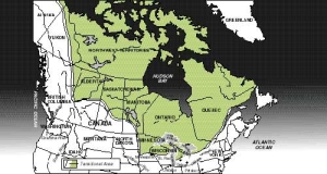
しかし、南は五大湖周辺州の北部から、内陸はカナダ国境まで広がり、アラスカ州の一部をも含む「北部地域(Northlands)」は、いまだに集落がまばらである。人を寄せつけない自然環境と、それに伴う定住地の乏しさは、「北部地域」に独特の性格を与えている。
 もし米国人が「北部地域」の特徴について尋ねられたら、最もよく使う形容詞はおそらく「寒い」だろう。この地域の1月の平均気温は、最も高い所が五大湖の南端沿いの-7℃で、アラスカ州の一部の-40℃まで、大きな幅がある。気温が-60℃になることもある。
この地域は、全体的に冬の気温が低いだけでなく、その期間も長い。春の最後の霜と秋の初霜までの平均日数は、この地域の南端部ではおよそ135日だが、北極海沿いでは14日にすぎない。主要な食用作物は、事実上すべてが90日以上の栽培期間が必要なため、この地域で栽培可能なのは、南端部の狭い地区だけに限られる。
夏は概して短く涼しいが、驚くほど気温が上がる日もある。海の影響で気候が穏やかになるのは、主に東部と西部の周辺部だけである。
このような気温の劇的な季節変動は、日照時間と太陽光線の入射角が大きく変化することに起因する。地球が太陽の周りを公転すると、北極は米国の夏にあたる時期に太陽に向かって傾き、冬には反対側に傾く。そのため、北極圏の北では冬至の頃に、1日中太陽が昇らない日が少なくとも1日あり、夏至の頃には24時間以上太陽が沈まないことが、少なくとも1回ある。さらに、冬期には、太陽は たとえ昇ったとしても地平線近くの低い位置にとどまるだけである。この地域の冬期の日照時間は、南部でさえもわずか6~7時間である。
降水量は「北部地域」全体で大きく異なる。最も降水量が多いのは南東部である。冬と夏とを問わず暴風圏が発生するため、ラブラドルの南岸沿いの年間降水量は1,000ミリメートル以上に達する。内陸へ、そして北に向かうにつれて、降水量は大幅に減少する。
降水量は少ないものの、「北部地域」で乾燥した自然環境の様相を呈する場所はほとんどない。それどころか、むしろ夏になると、この地域の大部分は貯留水で覆われる。このような寒冷地では蒸発および樹木による蒸発散量が低いことが貯留水の一因である。この地域の北部では、広範に存在する永久凍土層(地表下の永久に凍結している土で、通常でも深さ100メートルに及び、300メートル以上になることもある)もまた、貯留水を与えている要因である。もっと暖かい場所では、永久凍土層は断続的になり、凍土の地域に凍ってと凍っていない土壌が交互に入り混じる。短い夏の間に表層が溶け、おそらく1メートル程度の深さになると、その下の凍土層によって水は表面にとどまり、表面は沼地のようになる。
永久凍土層での建築作業は困難である。建物は、凍土層の中に深く沈めた杭の上に建設して安定させなければならない。道路は、少しでも平らな路面を保つために、毎年、大規模な改修工事を行わなければならない。アラスカ州の大部分の地下には、永久凍土層が連続的に、もしくは断続的に存在している。
「北部地域」の地形は、局地的にかなりの変化があるものの、そのほとんどは平坦か、もしくは緩やかに起伏している。例えばアラスカ北部の斜面は、広くて平らな沿岸平野となっている。
「北部地域」の土壌はさまざまだが、概して酸性で、水はけも悪く、農地としては質が低い。この地域の南部の土壌は大部分が、寒冷な針葉樹林環境にみられるボラルフ土壌またはスポドゾル土壌である。北部では、たいてい水分が飽和状態にあり凍ったツンドラ土壌が大半を占める。肥沃な土壌があるのは、古くからある川の流域の一部や、堆積物や腐敗植物が豊富な湖などに限られる。
「北部地域」の大部分は、はっきり2つの植生地域に分けられる。南の弓状の地域には、「北方林(boreal forest)」もしくは「タイガ」と呼ばれる針葉樹林が広がっている。トウヒ、モミ、マツ、アメリカカラマツなどの木々がびっしり連なり、何十万平方キロメートルもの土地に広がっている。上空から眺めると、黒に近い濃い色の塊が地表を覆っているように見える。これらの樹木は成長が遅く、本当の意味で背が高くなることは決してないが、タイガを南から北に向かうにつれて数が減り、次第に背も低くなる。五大湖周辺では、マツとカシやカエデなどの混合林が圧倒的に多い。
高木限界は、ハドソン湾の南を過ぎたところで北西に方向を変えてマッケンジー川の河口まで進み、アラスカ州北端部を横断している。これが「北部地域」のタイガからツンドラへの変わり目を示している。その北側では気候条件が厳しすぎて樹木となるような植物は育たない。ここには、地衣、草、コケ類、かん木が生えるツンドラ地帯が広がっている。
面積が約480万平方キロメートルに及ぶ北極海の大氷塊は、北極海に浮かぶ、薄くて(通常厚さ3~6メートル)ごつごつした、ほとんど塩分を含まない氷の板である。これに含まれる水の分量は、全世界の淡水湖がたたえる水の総量に匹敵する。冬期には南方に広がり、アラスカ州北部まで覆う。夏には氷が解けて、しばらくの間この地域は氷から解放される。
この氷があるため、北極海での海上輸送は夏の短い時期に限られ、その間はあわただしく輸送が行われることが多い。氷が早めに戻って来ると、船(そして、夏期に北極海に移動するクジラたち)が、氷のない南の海まで避難できなくなることもある。また、氷の存在によって、北極海が「北部地域」の気候を和らげる効果は最小限のものになる。
人口は「北部地域」のほぼ全域でまばらである。その中で最も人口密度が高いのは南端部である。米国より北の地域で圧倒的多数を占めるのは、アメリカ・インディアン、メティース、イヌイット(エスキモー)である。北極圏の大部分で最も人口の多いのがイヌイットである。アメリカ・インディアンは主に北方林地帯に住んでいる。メティースは、タイガにヨーロッパ人が移住した初期の毛皮貿易の時代に、アメリカ・インディアンの女性とフランス系白人の結婚によって生まれた混血の子孫である。
「北部地域」にヨーロッパ人が移住した結果、アメリカ・インディアンとイヌイットの伝統的な文化の多くが失われた。初期のころの毛皮商人は、タイガのインディアンから多くの毛皮を手に入れた。その結果、ヨーロッパの商品がインディアン経済に入ってきた。狩猟や漁業が続いているところでは、カヤック、弓、犬ぞりに替わってモーターボート、ライフル、スノーモービルが使われるようになった。しかし、「北部地域」には、狩猟や漁業で生活を営んでいるインディアンやイヌイットはもうほとんどいない。多数のインディアンやイヌイットが町に移ったため、現在の「北部地域」の都市では原住民の人口が多い。
米国にやってきた多くのヨーロッパ人にとって、「北部地域」はあまり関心を引くものがなかった。「北部地域」を定住地と決めた場合、その主な目的は普通、採取か軍事かどちらかだった。早くも17世紀の半ばには、毛皮会社に雇われたフランス人の船頭兼運び屋(voyageur)、わな猟師、商人がセントローレンス川の下流域の農業開拓地からさらに奥地へカヌーで進出し、フランスの政治的支配を五大湖地域全域に拡大した。初期のイギリス系毛皮取引会社であるハドソン湾会社は、カナダのハドソン湾沿岸に会社を設立して南と西に進出し、フランスの西方拡大を妨げた。18世紀半ばまでには、英国政府からこの地域での独占取引権を与えられたハドソン湾会社が、ハドソン湾西方のロッキー山脈までの北方林全域を支配し、さらに北極圏まで勢力を拡大していた。この広大な採取帝国が進出しても、それに伴う定住地は小規模で数が少なく、広い範囲に散らばっていた。
フランス人船頭兼運び屋やハドソン湾会社は、それぞれの地域にある数多くの湖や川を利用して輸送を行い、水路沿いの管制地点に小さな砦(のちの交易所)を築いた。重要な河川が湖と合流する場所や、川が終点になって陸上輸送が始まる場所、あるいは急流や滝がある場所では、船から荷物を下ろしてほかの船に積み換えなければならなかった。これらの場所が水系全体を効果的に管制する役割を果たした。かつてフランスの砦だった場所の多くが、今では重要な都市中心部となっている。シカゴ、デトロイト、ピッツバーグなどもそうである。
「北部地域」の南半分にある北方林には、北米に残る最大の未開発林地域がある。つい最近まで、製材業やパルプ・紙産業は、この広大な森林の端の部分を、遠慮がちに利用していただけだった。五大湖北部の地域は、1800年代末と20世紀初頭に、大規模な伐採が行われた。当時は再植林がほとんど行われていなかったことと、寒冷な気候によって森林の再成長に時間がかかることから、この地域の大部分は、今ようやく以前の姿を取り戻し始めたところである。
「北部地域」のうち五大湖北部の一帯は、国内有数の鉄鉱石と銅の産地である。アラスカ州のノーススロープから石油が産出されるようになったことで、米国のエネルギー供給量は大きく増加した。現在では米国の総石油産出量の約25%をこの地域が産出している。
製材業と同様に、「北部地域」の中でも人が足を踏み入れることができる周辺地域は、この地域で最初の重要な鉱業地区になった。ミネソタ州北部のメサビ山地はなだらかに起伏する細長い丘陵地帯であり、19世紀末に、同州や、ウィスコンシン、ミシガン両州にまたがる近隣地域とともに、国内の主要な鉄鉱石産地に発展した。何十億トンもの高品質の鉄鉱石がスペリオル湖の港に鉄道で運ばれ、そこで、湖専用の大型船に積まれて、オハイオ州北東部の港に運ばれた。鉄鉱石はここで再度鉄道に積み換えられ、ピッツバーグ・ヤングズタウン地区の製鉄・製鋼所に運ばれた。今日では、ほとんどの鉄鉱石は、ミシガン湖の南端にある新しい一貫鉄鋼製造施設に運ばれる。スペリオル湖をその他の五大湖と結ぶスーセントマリー川の閘門は、世界で最も交通量が多いが、これは概して鉄鉱石の輸送によるものである。
高品位の鉄鉱石は、現在ほとんどがスペリオル湖の鉱業地帯から姿を消した。また、同地区に大量に埋蔵しているタコナイトと呼ばれる低品位の鉄鉱石に注目が集まってきている。タコナイトの鉄含有量はおよそ30%で、高品位の鉄鉱石のおそらく半分ぐらいしかないため、五大湖南部に運んで加工するにはコストがかかりすぎると考えられている。そこで、鉄鉱石を細かい粉状に粉砕し、岩石の大部分を取り除いたものを押し固めて、鉄の含有量が高い小さな粒にする。こうすれば、タコナイトの輸送コストが大幅に下がることになる。
低品位鉱石の輸送コストの問題が、市場の近くではなく、供給源の近くに溶解工場を置く大きな要因である。例えば銅の場合、鉱石の含有量は最大でも5%で、1%未満のことも多いため、ほとんど常に鉱山の近くで精製する。鉱石の溶解と精製は「北部地域」の製造業における労働者雇用の主流であり、この地域のいくつかの大都市では、精製所の大きな煙突が都市景観の中心的な要素となっている。
米国は、アラスカ州のノーススロープ油田の開発を進めるべく迅速な対応をした。この地域での石油探査権だけのために、10億ドル以上も支払った産油国もあったほどである。
原油の輸送は、ノーススロープ油田の開発における一番の問題点だった。アラスカ州中部を通って太平洋側のバルディーズ港まで延びるパイプラインが80億ドルかけて建設され、結局1977年に操業を開始した。
「北部地域」では人口が少なく、特に都市が存在しないことは、たとえ輸送ルートを安価に建設できたとしても、その使用頻度が比較的少ないことを意味する。この地域の西端まで貫通しているのは、アラスカハイウェイとその枝分かれした何本かのルートだけである。
一方、この地域のほぼ全域では、辺境を飛ぶ小型航空機とその操縦士が、唯一の輸送手段である。北部では、20近い航空会社が、比較的密度の高いルートで定期運航を行っている。
この地域の総人口は多くないが、大多数の人々は村、町、都市に住んでいる。集落が分散しているほかの地域では、農業が主要な生計手段の1つだが、ここでは局地的な重要性しかない。大きな都市のほとんどは南部に集中しており、主な経済活動は1つしか持っていない。例えばミネソタ州のダルースは輸送の中心地というだけである。同様に、北方林にある小さな町も、ほとんどはそれぞれ単一の機能しか持っていない。
極北では、ヨーロッパ人の開拓によって恒久的な定住地が形成されることは、ほとんどなかった。この地域に住む多くの人々は、何らかの形で米国政府や資源開発の仕事に携わっている。極北の地域社会は男性ばかりという所が多く、著しく孤立している。労働者は頻繁に数週間の休みを取り、家庭に帰ったり、レクリエーションに行ったりする。鉱物の採掘だけに従事しているあらゆる地域共同体と同様に、極北の集落も、しばしば資源の枯渇によって短命に終わってしまうことになる。
*上記の日本語文書は参考のための仮翻訳で、正文は英文です。
The Northlands
(The following article is taken from the U.S. Department of State publication, An Outline of American Geography.)
The Northlands
By Stephen S. Birdsall and John Florin
The United States is in many ways a creation of a frontier experience. The push westward remains part of recent American history, and many still live who remember the days of early settlement, of the often heroic struggle with the land.
The American frontier is largely gone today. Although humans presumably have the technology to live anywhere on the earth's surface, those areas of the United States that can be occupied with moderate physical and economic effort are already staked out.
Extending as far south as the northern Great Lakes states and including the interior to the Canadian border, as well as parts of Alaska, the Northlands remains sparsely settled. The inhospitable nature of the physical environment plus the consequent thinness of settlement give the Northlands its special character.
A HARSH ENVIRONMENT
If Americans were asked to describe the Northlands, "cold" would probably be the most commonly used adjective. Average January temperatures range from a high of about -7°C along its southern Great Lakes margin to a full -40°C in parts of Alaska. Temperatures can reach -60°C.
Not only are winter temperatures low across most of the region, but winters are long. The average time between the last frost in the spring and the first in the fall is roughly 135 days at the southern margins of the area but little more than 14 days along parts of the Arctic Ocean. Because virtually all major food crops need a growing season of longer than 90 days, they can be grown in only a few small areas along the southern margins.
Summers, generally short and cool, can have surprisingly warm days. Maritime moderation is significant only along the peripheries, mainly in the east and west.
This dramatic seasonal variation in temperature results from the great shifts in length of day and the angle of incidence of the sun's rays. As the Earth follows its annual path around the sun, the North Pole is tilted toward the sun during what is summer in America and away from it in winter. Thus, everywhere north of the Arctic Circle is in darkness for at least one day at midwinter and experiences at least a 24-hour period without the sun setting at midsummer. Moreover, during the winter, the sun, when it rises, remains low on the horizon. Even southern sections of the region receive only six or seven daylight hours during the winter.
Precipitation amounts vary widely across the Northlands. Highest levels are found in the far southeast, where both winter and summer storm systems dump more than 100 centimeters of annual precipitation along the southern shore of Labrador. Precipitation levels drop markedly toward the interior and north.
Despite the paucity of precipitation, little of the Northlands provides the appearance of a dry environment. In the summer, in fact, much of the region is covered with standing water. This is due, in part, to the low levels of evaporation and evapotranspiration found in this cold climate. In the northern portions of the region, standing water is also supported by the widespread existence of permafrost--a subsurface layer of permanently frozen ground that is commonly about 100 meters thick and sometimes extends downward for more than 300 meters. In warmer areas, the permafrost is discontinuous, with areas of frozen ground interspersed with unfrozen soil. As the surface layer thaws during the short summer to a depth of perhaps 1 meter, water is held on the surface by the frozen layer underneath, creating a boggy, shifting surface.
Construction in permafrost is difficult. Buildings must be placed on piles sunk deeply into the permafrost for stability, and roads must be repaired extensively each year to maintain any resemblance of an even roadbed. Most of Alaska is underlain by continuous or discontinuous permafrost.
Although considerable local terrain variation is found, much of the Northlands topography is either flat or gently rolling. The north slope of Alaska, for example, is a broad, flat coastal plain.
Northlands soils are varied but are generally acidic, poorly drained, and of low agricultural quality. Soils in the southern portion of the region are mostly boralfs or spodosols soils of a cool needleleaf forest environment. To the north, tundra soils, often water saturated and frozen, dominate. Fertile soil is confined to some of the old river valleys and to those lakes that have been filled by sedimentation and decayed vegetation.
Most of the Northlands can be placed in two distinct vegetation areas. Stretching across the southern arc of the region is a coniferous forest called the boreal forest, or taiga. Covering hundreds of thousands of square kilometers, these closely ranked spruces, firs, pines, and tamaracks appear to blanket the landscape in a dark, almost black mass when seen from the air. Slow growing and never really tall, these trees decrease in number and height from south to north across the taiga. Around the Great Lakes, a mixture of pines and hardwoods predominate.
Passing just south of Hudson Bay, then angling northwest to the mouth of the Mackenzie River and across the northern edge of Alaska, is the tree line, which identifies the transitional zone between the taiga and tundra in the Northlands. North of it, climatic conditions are too harsh for tree-like vegetation. Beyond lies the tundra, a region of lichens, grasses, mosses, and shrubs.
The great Arctic ice pack, covering some 4.8 million square kilometers, is a thin (usually 3 to 6 meters thick), rugged sheet of nearly salt-free ice floating on the Arctic Ocean. It holds as much water as all the freshwater lakes in the world. In winter it extends southward to enshroud northern Alaska. Summer melt briefly frees the area.
The ice limits ocean transport in the Arctic to a brief, often hectic period each summer. An early return of the ice can sometimes block ships (and whales that migrate into the Arctic Ocean during the summer) from escaping to open water to the south. The ice also minimizes any moderating impact by the Arctic Ocean on the Northlands' climate.
HUMAN OCCUPATION
Nearly all parts of the Northlands are sparsely populated, with highest densities found along the southern margins. American Indians, Metis, and Inuit (Eskimos) are numerically dominant over much of the region north of the United States. Inuit are the predominant population in most of the Arctic. American Indians are found mainly in the boreal forest area. The Metis are the result of intermarriage between American Indian women and whites during the early fur trading period of European settlement in the taiga.
The arrival of Europeans in the Northlands brought an end to much of the American Indian and Inuit traditional culture. Fur traders early acquired many of their pelts from the Indians of the taiga, and European goods entered the Indian economy as a result. Where hunting and fishing continue, the motorboat, rifle, and snowmobile have usually replaced the kayak, bow, and dogsled. But most Northlands Indians and Inuit no longer exist by hunting and fishing. They have moved in substantial numbers into towns, and many urban places of the Northlands today have large native populations.
The Northlands offered little of interest to most Europeans who came to America. Where Northlands settlement did occur, its focus was usually either extractive or military. French voyageurs, fur trappers, and traders pushed their canoes far beyond the agricultural settlements along the lower St. Lawrence River as early as the middle of the 17th century, extending French political control across the Great Lakes. The Hudson's Bay Company, an early British fur trading company, established itself on the margins of Hudson Bay in Canada and then pushed south and west, thus blocking further French expansion westward. By the mid-18th century, the Hudson's Bay Company, which had been granted a trade monopoly to the area by the British government, was in control of the entire boreal forest reaching from Hudson Bay westward to the Rocky Mountains, with further extension of influence into the Arctic. This vast extractive empire brought with it only a minimal number of small and widely scattered settlements.
The voyageurs and Hudson's Bay Company relied on the numerous lakes and streams of their area for transportation, and they located small forts at control points along the water routeways. At places where important streams met lakes, where streams ended and an overland portage began, or where rapids or falls were encountered, vessels had to be unloaded and their goods moved and reloaded onto other boats; these points provided effective control of the entire water system. The sites of many early French forts are occupied today by important urban centers, including Chicago, Detroit, and Pittsburgh.
The boreal forest of the southern half of the Northlands contains the largest area of uncut forest remaining in North America. Until recently, the lumbering and the pulp and paper industries only nibbled at the edges of this vast forest. The area of the upper Great Lakes was logged on a massive scale during the late 1800s and the early 20th century. Because little reforestation was practiced at that time and because the cold climate of the boreal forest slows regrowth, much of this area is only now recovering its previous appearance.
The portion of the Northlands in the upper Great Lakes area is America's leading source of iron ore plus a substantial contributor of copper. Alaskan North Slope petroleum has recently provided a large addition to the American energy supply, presently pumping about 25 percent of the country's total production.
As with logging, the accessible peripheries of the Northlands became the region's first important mining districts. The Mesabi Range in northern Minnesota, an area of gently rolling elongated hills, along with neighboring areas in Minnesota, Wisconsin, and Michigan, developed into America's chief source of iron ore late in the 19th century. Billions of tons of high-grade ore were moved by rail to Lake Superior ports and loaded there onto large specialized lake ships that carried the ore to ports in northeastern Ohio, where it was transferred to railroads for the trip to iron- and steel-processing plants in the Pittsburgh-Youngstown area. Today, most ore goes to the newer, integrated iron and steel facilities at the southern end of Lake Michigan. Locks at Sault Sainte Marie that connect Lake Superior with the rest of the Great Lakes are the busiest in the world, largely as a result of this ore traffic.
Most of the high-quality iron ores are now gone from the Lake Superior mining district. Attention has turned to a lower-grade ore called taconite, also found in huge quantities in the district. The iron content of taconite, roughly 30 percent compared to perhaps double that for the richer ores, is so low that to ship the ore to the lower Great Lakes for processing is considered far too expensive. Thus, the ore is ground into a fine powder, much of the rock removed, and the resulting material pressed into small pellets with a much higher iron content, which greatly lowers the cost of shipping taconite.
The cost of shipping low-grade ores is the major factor in choosing to locate many smelting operations near the source of supply instead of near the market. For example, copper, which seldom represents as much as 5 percent of its ore and often less than 1 percent, is nearly always refined near the mine. The smelting and refining of ores is the major form of manufacturing employment in the Northlands, and the large smokestacks of refineries are the central element in the skyline of some of the region's larger cities.
The United States has moved rapidly to develop its North Slope petroleum fields in Alaska. Some oil producers paid well over $1 billion just for the right to search for oil in the region.
Transportation of crude petroleum was the principal problem involved in opening the North Slope fields. A pipeline costing $8 billion and crossing central Alaska to the port of Valdez on the Pacific was finally built and opened in 1977.
The Northlands' sparse population, and especially its lack of cities, mean that even if transportation routes could be constructed cheaply, they would be used relatively little. Only the Alaska Highway and some of its branches pass through the western margins of the region.
For much of the region, however, the light airplane and its bush pilot is the only transportation link available. Close to a score of carriers operate a relatively dense pattern of scheduled routes in the north.
Although the total regional population is not large, the great majority of people in the Northlands live in villages, towns, and cities. Agriculture, a major support of dispersed settlement elsewhere, is only locally important. Nearly all of the larger cities are dominated by a single major economic activity and are located in the south--Duluth, Minnesota, as a transportation center, for example. Most smaller towns in the boreal forest are similarly unifunctional.
In the far north, European development has resulted in few permanent settlements. Many people in the area work, in some capacity or another, for the U.S. government or in resource exploitation. Far northern communities are extremely isolated, often with predominantly male populations, and the labor force frequently spends periods of weeks away from the communities for family visits and recreation. As with communities everywhere that are totally focused on minerals extraction, they are often short-lived, owing to resource depletion.
[Stephen S. Birdsall is dean of the College of Arts and Sciences at the University of North Carolina at Chapel Hill. He holds a master's and a doctoral degree in geography from Michigan State University and is the co-author of four books and atlases, including Regional Landscapes of the United States and Canada.]
[John Florin is chair of the geography department at the University of North Carolina at Chapel Hill. He holds a master's and a doctoral degree in geography from Pennsylvania State University. His recent publications include Atlas of American Agriculture: The American Cornucopia with Richard Pillsbury and Regional Landscapes of the United States and Canada with Stephen S. Birdsall.]