
国務省出版物
米国の地理の概要 – 南西部国境地域
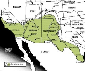
一般的に「南西部(Southwest)」と呼ばれている地域の存在は広く知られているが、同時にここは、最も変化を続けている地域のひとつでもある。主として、晴天が多く乾燥した気候のせいで、地域内の自然環境は均質的に感じられるが、実際には、リオグランデ川下流域には広大な平地が広がる一方、ニューメキシコ州には複数の高原があり、またアリゾナ州の印象的な地形はメサ(訳注=周囲が崖で、頂上が平らな地形。プラトーより小さく、ビュートより規模が大きい。)とビュート(訳注=孤立した周囲が切り立った丘)と砂漠で構成されている。さらに、ニューメキシコ州にはサングレ・デ・クリスト山脈がある。
 「南西部」は、スペイン系米国人文化とアメリカ・インディアン文化、英国系文化の共存を特徴としており、自然環境はそれぞれの文化の特質を際立たせる役目を果たす舞台のような働きをしている。アメリカ・インディアンとスペイン系米国人は、16世紀末にスペインからの移民が始まって以来、250年間にわたりこの地で共存しており、その後、19世紀半ばに英国系の人々が移住を始めた。
しかし、3つの文化が共存するこの国境地域は、今では非スペイン系と非アメリカ・インディアンが圧倒的多数を占めている。おそらく、スペイン系の姓を持つ人は4人に1人程度であり、アメリカ・インディアンの比率は1%に過ぎないだろう。そこで、この2つの少数民族は、人口が多くて比較的均質な英国系人口に飲み込まれてしまうのではないか、と考える向きもあるかもしれない。しかし、この2つの少数民族グループはどちらも、この地域に継続的に大きな影響を及ぼしてきた。スペイン語の地名も豊富で、特にリオグランデ川沿いとカリフォルニア州沿岸部に顕著である。アメリカ・インディアン系の地名は局地的に目立って存在し、特にアリゾナ州のナバホ族、ホピ族、パパゴ族の特別保留地に多い。スペイン系の人々が住む地域は、建物にアドービ(日干し粘土)煉瓦を使っていることで特定できることもあるが、それよりも、家を塗装するときの鮮やかな配色や外壁の装飾、庭を囲う派手なフェンスでわかる場合が多い。「ホーガン」と呼ばれる独特の住居(側面がほぼ垂直で屋根が丸い木材と泥でできた建物)は今でもナバホの特別保留地に見られるし、ニューメキシコ州にある特徴的なプエブロ住宅は、同州を代表する建築様式の一つである。
アリゾナ州北部からユタ州南部にかけての渓谷地帯は、スペイン人がメキシコから北へ拡大する際に、大きな障害となった。スペイン人はリオグランデ川をさかのぼって広大なロッキー山脈まで進んだが、そこからさらに北には、スペイン人の集落は発展しなかった。テキサス州では、ほとんどの開拓地はリオグランデ川とニュエイセス川沿いに集中した。スペイン人がテキサス州南部に持ち込んだ大規模放牧業は、湿度が高く森林が多いテキサス州東部の土地には適していなかった。この一帯は辺境地域のまま取り残され、スペイン人はほとんど定住しなかった。この最初の開拓地以外にスペイン系米国人が移住したのは、ほぼ都市部に限られている。
アリゾナ州やニューメキシコ州、さらに互いに州境を接するユタ州とコロラド州の一帯はひどく乾燥しているため、19世紀に入っても英国系の人々による大規模な農地開拓は進まなかった。そのため、これら4州にはアメリカ・インディアンが多数とどまることになった。リオグランデ川上流域のプエブロ族が、ヨーロッパ人による移民が始まる前に発達させたインディアン文明は、後にアメリカ合衆国となる地域では、技術的に最も進歩したものだった。そして、ニューメキシコ州における彼等の重要性は今も変わらない。もともと主としてアリゾナ州にいたナバホ族とホピ族とアパッチ族は、米国東部のほとんどの部族と比べると、ヨーロッパ移民の大波をうまく生き延びたアメリカ・インディアンでもある。
「南西部」のアメリカ・インディアンは、文化的に多様である。アメリカ・インディアン最大の部族には、コロラド、ユタ、アリゾナ、ニューメキシコの4州が接する「フォーコーナーズ」地域に住むナバホ族、アリゾナ州とニューメキシコ州の複数のアパッチ族、ニューメキシコ州の様々なプエブロ族のグループ、アリゾナ州北西部のホピ族、コロラド州南西部のユート族がある。
ほとんどのアメリカ・インディアンは、「フォーコーナーズ」とカリフォルニア州を中心とする主な特別保留地域に居住している。特に「フォーコーナーズ」の62,000平方キロメートルのナバホ保留地に住むアメリカ・インディアンの人口は、ほかの保留地の10倍である。アリゾナ州とニューメキシコ州には合わせて30万人のアメリカ・インディアンが暮らしている。
16世紀初頭、今日の米国南西部と言われる地域は、すべてスペイン帝国に組み込まれていた。1550年までにはスペイン人はこの地域の広い範囲で探査を終えていた。容易に確認でき、採取できる資源が見つからなかったことに加え、メキシコでのスペイン人開発地域の中心から遠く離れていたため、北部の領土に対するスペイン人の関心は、極めて薄かった。
1700年以前に現在の米国・メキシコ国境の北側でスペイン人が定住していたのは、ニューメキシコ州のリオグランデ川上流域だけだった。代表的なプエブロ(小さな集落の意味)、サンタフェが1610年に建設され、ほかのプエブロ、特にタオスとアルバカーキもその直後に作られた。
スペインによるアリゾナ州の一時的な占有は1700年に始まった。アパッチ・インディアンはこの地域のスペイン人植民地を繰り返し襲撃したため、スペイン人にとっては常に脅威となっていた。ほぼ同時期に始まったテキサスの植民地化は長期的にはアリゾナよりも高い成果をあげた。1716年にナコドーチェズ市が、その2年後にサンアントニオ市が作られた。1700年代半ばを通じて、リオグランデ川下流域にスペイン人が移住した。さらに、19世紀初め頃までにテキサスに向かって西進を続ける米国人の数と比べると、これらのスペイン人居住地は占領形態として規模が小さく十分でない、とスペイン政府は考えるようになった。かくして1820年代から1930年代には、米国人を中心とするスペイン系以外の人々にもここでの植民地開拓が許されるようになった。
スペインの北部領土のうち最も遠方にあるカリフォルニアは、最後に開拓された地域である。1769年に伝道所と駐屯地がサンディエゴに設立された。その後の20年間に、一連の伝道所のほか、少数の駐屯地とプエブロが、サンフランシスコの北にあるソノマまで海岸に沿って作られた。このように沿岸の細長い地域を占有した理由のひとつは、英国とロシアが西海岸への関心を高めていたことである。
1845年に米国がテキサス州を併合し、1848年にメキシコ・米国戦争が終結した後、この広大な土地に住んでいたメキシコ人の推定人口は82,500人だった。このうち6万人はニューメキシコ州に、14,000人はテキサス州に、7,500人はカリフォルニア州に、そして1,000人はアリゾナ州に住んでいた。
1850年までに、テキサス州とカリフォルニア州に住むメキシコ人の比率は、両州の全人口の10%未満に減少した。非スペイン系人口が急増した背景にはいくつか大きな理由がある。テキサス州東部は、南部の開拓地にとって新たな西の辺境だった。また、1848年にカリフォルニア州で金が発見されたため、カリフォルニアの中部と北部に非スペイン系の人々が殺到した。その後さらに数十年間にわたってヒスパニック系の人口が多数派を占めていたのは、ニューメキシコ州とカリフォルニア州南部、そしてサンアントニオよりも南のテキサス州だけだった。
「南西部」に元々住んでいたヒスパニック系の人口は、特に20世紀に入ってヒスパニック系の人々が大勢移民してきたことで、大幅に増加した。1990年には、スペイン系の姓を持つ住民の数はアリゾナ州の全人口の18.8%を占めた。カリフォルニア州ではこの比率が26%、コロラド州では13%、ニューメキシコ州では38%、テキサス州では26%だった。1990年の国勢調査では、全米のヒスパニック系人口は2,080万人となっており、1980年よりも34%増加している。ヒスパニック系人口の60%以上がメキシコ系米国人である。
英国系とヒスパニック系やアメリカ・インディアンとの間には、著しい経済格差が存在する。都市化の程度に違いがあることが、この格差を生み出す1つの要因である。英国系米国人は最も都市化が進んでおり、アメリカ・インディアンは最も遅れている。都市居住型の米国人には、高収入、高学歴で子どもの数が少ないという特徴がある。
しかし、ナバホ特別保留地の発展ぶりを見ると、(ただ、ナバホの状況が標準的とは一概に言えないが)保留地の状況が変化していることがわかる。最終的な権限は今も米国政府のインディアン局にあるものの、保留地の大多数の経済問題については、選挙で選出された部族会議が決定を下す。保留地への政府予算歳出は、1950年以降に急増した。今では全天候型の道路がナバホ保留地を通り、孤立状態が大幅に緩和されているほか、保健と教育の施設も充実した。また、ナバホの土地で化石燃料、特に大量の石炭の埋蔵が発見された。さらに、この保留地にある複数の大規模発電所で作られた電力が、カリフォルニア州南部に送られている。電力会社による保留地経済への貢献は、毎年数百万ドルに上る。また、観光業も大きく成長したほか、高い教育を受けた大量の労働力を武器に、多数の新しい産業の誘致を引き寄せている。
第一次世界大戦中と1920年代初期の好況期には、米国の労働需要を満たすため、大量のメキシコ人が国境を越えてやってきた。1940年代に米国が再び戦争による労働力不足に陥ったため、その後20年間、メキシコ人労働者は米国に入国して農業分野で季節労働者として働くことができた。
1965年、メキシコは国境工業化プログラム(Border Industrialization Program)を開始した。米国の労働集約型製造業をメキシコ北部の国境地域に誘致することを目的としていた。こうした外国企業は「マキラドーラ」と呼ばれ、完成した製品をメキシコから輸出する場合に限り、設備や原材料を関税非課税でメキシコに輸入することができた。1989年にこの規制は緩和され、今ではマキラドーラも全製品の50%をメキシコ国内で販売することができる。
メキシコにとって、このプログラムは、国民に雇用機会を提供することができるものだった。米国企業にとっては、米国市場や原材料の供給源に近い場所で低賃金の労働力を使うことができ、輸送コストも削減できることが魅力だった。このコスト削減の機会に多くの企業が引きつけられ、1990年末までには、推定で1,800社のマキラドーラが50万人以上のメキシコ人を雇用していた。
「南西部」は米国で最も日照時間が長く乾燥している。この地域全体を特徴付ける植生はバンチグラス、メスキート、サボテンである。この地域の気温は場所によってかなり違う。カリフォルニア州南部や、アリゾナ州、テキサス州南部では、夏が暑く、冬は暖かくて短い。ニューメキシコ州のリオグランデ川上流域では、夏は暑いものの、反対に冬の気温は氷点を大きく下回ることがある。
このように変化に富んでいるにもかかわらず、「南西部」の日光に満ち溢れた気候は、多くの米国人を引きつけて止まなかった。1980年代のアリゾナ州は、ネバダ州とアラスカ州に次いで、人口増加率が全米で3番目に高い州だった。実際には、「南西部」に含まれるすべての州で、1980年代の人口増加率が全米平均を大幅に上回っていた。フェニックス市の規模は1950年以降数倍に膨れ上がり、今では急速に発展する全米第20位の都市である。1960年に26万6,000人だったトゥーソン大都市圏の人口は、1990年には66万7,000人に増加した。これらの人口密度の低い都市部は、かつて砂漠だった広大な地域に数キロメートルにわたって広がっている。
初期の頃、「南西部」が人々を引きつけたのは、その乾燥した環境が、呼吸器系疾患の患者にとって健康増進効果があったことも一因である。今日では、この地域の中でも、より温暖な場所に、現役を引退した米国人が何千人も集まってきている。
さらに、アリゾナ州は多くの産業や企業を引き寄せている。第二次世界大戦中、フェニックスでは、カリフォルニア州南部の航空機製造大型複合体に近いことと、飛行に適した天候に恵まれていることを活かして、航空機産業が発展した。労働者を強く引きつける環境があるため、多くの雇用者はアリゾナ州南部に事務所を構えた。アリゾナ州が大多数の国内主要市場から比較的遠く離れていることは、以前であれば同州の成長に重大な影響を及ぼしたかもしれない。だが、電子機器のような高価値・軽量の製品が作られるようになったことで、そうした不利はほとんどなくなってしまった。
テキサス州エルパソとニューメキシコ州アルバカーキも、1950年から1970年の間に規模がおよそ2倍になり、それ以降も急速な成長を続けている。この2つの都市とサンアントニオは、大規模な軍事基地の存在によって利益を受けてきたが、同時に軽工業もまた様々な形で発展している。
このほかのニューメキシコ州内や、「南西部」に含まれるテキサス州の地域では、人口増加にもっと大きなむらがある。リオグランデ川下流域の多くの農村部や、コロラド州南部とニューメキシコ州東部のほとんどでは、過去数十年間で人口が減少し、米国のほかの農村地域と同じ運命にある。
米国におけるスペイン開拓地の中心であったニューメキシコ州中・北部の田園地帯の高地は、アルバカーキやアリゾナ州南部を席巻した英国系移民文化からの影響を驚くほど受けておらず、昔の特徴が今も残っている。ニューメキシコ州北部の高地では、人口のおよそ70%をヒスパニック系が占め、小さな町の多くでは全人口がヒスパニックである。プエブロ族を中心とするアメリカ・インディアンは、これよりはずっと数が少ないが、この地域の農村に残る非英国系文化の中で非常に目立つ特徴となっている。
サンタフェの北にある田舎道の沿線には日干し煉瓦でできた古い村やスペイン語の標識が文化的景観を支配している。アルバカーキ近郊の高速道路沿いには、ニューメキシコ州の中・北部一帯と同様に、「プエブロ」と呼ばれる数世紀前に建設されたアパートのようなインディアンの村々がある。その昔ながらの外観は、低層の建物が無秩序に広がる新しい市街地と好対照を成している。各プエブロはその周辺のかなりの土地を管理しており、これが英国系社会と一線を画す役割を果たしている。プエブロ社会とその伝統には活力があり、繁栄している。ニューメキシコ州の州都であるサンタフェには、日干し煉瓦建築、開かれた中央広場、メキシコ北部の食べ物や商品を扱うレストランや店舗などが見られ、スペインの香りが残っている。v
テキサス州のリオグランデ川下流域にあるウィンターガーデン地区もまた、圧倒的にヒスパニック系の人口が多く、灌漑農業の主要地域になっている。耕作適期が平均280日以上と長いため、オレンジ、グレープフルーツ、冬レタス、トマトなどの作物を栽培することができる。長年この灌漑農業を支えてきたのは、ヒスパニック系の労働者である。v
ロサンゼルスでは、ヒスパニック系の居住地におそらく数十万人が居住している。英国系社会への文化変容は、リオグランデ川の上下流域よりもずっと進んでいるにもかかわらず、ヒスパニックの伝統は今も大きな影響力を持つ。スペイン語のラジオ局や新聞が多く存在し、メキシコ系米国人の大きな祭りには、大勢の人々が集まってくる。
つまり、「南西部の国境地域」では、ヒスパニック文化とアメリカ・インディアン文化の影響が色濃く残っているのである。
*上記の日本語文書は参考のための仮翻訳で、正文は英文です。
The Southwest Border Area
(The following article is taken from the U.S. Department of State publication, An Outline of American Geography.)
The Southwest Border Area
By Stephen S. Birdsall and John Florin
The area known generally as the Southwest is one of the most widely recognized yet one of the most transitionary regions of America. It has an apparent physical uniformity that can be attributed primarily to its clear, dry climate, but, in fact, the region includes the broad flatlands of the lower Rio Grande Valley; the plateaus of New Mexico; the dramatic mesas, buttes, and deserts of Arizona; and the Sangre de Cristo Mountains of New Mexico.
The Southwest is made distinctive by the coexistence of Spanish-American, American Indian, and Anglo cultures, and the physical environment is almost like a stage that serves to emphasize aspects of each. The American Indian and Spanish populations coexisted in much of the region for 250 years after Spanish arrival at the end of the 16th century before Anglos began immigrating in the middle of the 19th century.
However, the tricultural border region is now preponderantly non-Spanish and non-Indian. Perhaps one person in four has a Spanish surname, and little more than 1 in 100 is an American Indian. The expectation might be that these minority populations would be engulfed by the larger and relatively homogeneous Anglo population. But both minority groups have had a major sustained impact on the region. Spanish place-names abound, especially along the Rio Grande River and in coastal California. American Indian place-names are locally important, especially on the Navajo, Hopi, and Papago reservations in Arizona. Hispanic neighborhoods are sometimes identified by the use of adobe, but more often by the use of bright colors in house painting and outside ornamentation and by yards encircled with bold fences. The distinctive hogan (a building made of logs and mud with near-vertical sides and a rounded top) can still be found on the Navajo reservation, and the pueblos of New Mexico are a striking element of that state's architecture.
The canyonlands of northern Arizona and southern Utah provided an effective barrier to Spanish expansion northward from Mexico. The Spanish moved up the Rio Grande to the broad expanse of the Rocky Mountains, north of which little Hispanic settlement developed. In Texas, most settlement remained concentrated along the Rio Grande and Nueces Rivers. The extensive cattle-grazing industry that the Spanish introduced into south Texas was ill-suited to the moist, forested lands of the eastern portion of the state. That area, left as a frontier, was largely unsettled by the Spaniards. Most migration by Spanish-Americans beyond this original settlement area has been to urban places.
The aridity of Arizona, New Mexico, and bordering areas in Utah and Colorado discouraged large-scale Anglo agricultural settlement into the 19th century, ensuring that substantial numbers of American Indians remained in the four states. The Pueblo of the upper Rio Grande Valley had developed the technologically most advanced pre-European Indian civilization in what was to become the United States, and they remain important in New Mexico. The Navajo, Hopi, and Apache, all primarily in Arizona, also survived the European wave better than most eastern tribes.
ETHNIC DIVERSITY
The Southwest's American Indian population is culturally diverse. The largest tribes are the Navajo in the "Four Corners" area, where the states of Colorado, Utah, Arizona, and New Mexico meet; several Apache tribes in Arizona and New Mexico; the various Pueblo groups in New Mexico; the Papago in southern Arizona; the Hopi in northwestern Arizona; and the Utes in southwestern Colorado.
Most American Indians are found in the major reservation areas, especially those centered on the Four Corners--where the 62,000-square-kilometer Navajo reservation has 10 times the population of any other reservation--and in California. Arizona and New Mexico together are the home for some 300,000 American Indians.
All of what is today the southwestern United States was incorporated into the Spanish Empire during the early years of the 16th century. By 1550, the Spanish had explored widely across the region. The lack of any identified, easily extractable riches, coupled with the great distance to the core of Spanish development in Mexico, minimized Spanish concern for their northern territory.
Before 1700, the only permanent Spanish settlements north of the present U.S.-Mexico border were along the valley of the upper Rio Grande in New Mexico. Santa Fe was founded in 1610, and other pueblos (civilian communities that could loosely be viewed as small towns), notably Taos and Albuquerque, soon followed.
A tentative Spanish occupation of Arizona began in 1700. The Apache Indians were a constant threat, repeatedly raiding Spanish settlements in the area. Colonization of Texas began at about the same time, with long-range results that were considerably more successful. Nacogdoches was founded in 1716, followed two years later by San Antonio. During the middle 1700s, the lower Rio Grande Valley was settled by the Spanish. Still, by the early 19th century, these and other centers of Hispanic settlement were viewed by Spanish authorities as a small, inadequate occupation compared with the large number of Americans then pushing westward toward Texas. Thus, foreigners, mostly Americans, were allowed to develop settlements there during the 1820s and 1830s.
California, the most distant of Spain's northern territories, was the last to be settled. A mission and presidio (military post) were established at San Diego in 1769. During the next two decades, a string of missions, with a few presidios and pueblos as well, was established along the coast as far as Sonoma, north of San Francisco. This thin band of coastal occupation was encouraged partly in response to a growing British and Russian interest in the West Coast.
After U.S. acquisition of Texas in 1845 and the end of the Mexican-American War in 1848, the estimated Mexican population of this broad territory was 82,500. Of this number, 60,000 were in New Mexico, 14,000 in Texas, 7,500 in California, and 1,000 in Arizona.
By 1850, Mexicans in Texas and California represented less than 10 percent of the two states' total populations. There were good reasons for the rapid increase in the non-Spanish population. East Texas was the new western frontier for southern settlements, and the discovery of gold in California in 1848 was largely responsible for the influx of non-Spanish peoples into central and northern portions of the state. Only in New Mexico, southern California, and Texas south of San Antonio did the Hispanic population continue to dominate for a few more decades.
The original Hispanic population of the Southwest has been greatly increased by substantial immigration, especially during the 20th century. In 1990, persons of Spanish surname represented 18.8 percent of the population of Arizona; in California, the proportion was 26 percent; in Colorado, 13 percent; in New Mexico, 38 percent; and in Texas, 26 percent. In 1990, census figures placed the Hispanic population of the United States at 20.8 million, an increase of 34 percent over 1980. Over 60 percent of the Hispanic population is Mexican-American.
The economic gap between Anglos and Hispanics and American Indians is considerable. Differences in urbanization account for some of the variation; in the Southwest, Anglos are the most urbanized; American Indians, the least. Urban Americans tend to have higher incomes, more education, and fewer children.
Developments on the Navajo reservation, however, although not entirely typical, are indicative of altered reservation conditions. Final authority remains with the U.S. government's Bureau of Indian Affairs, but an elected tribal council makes most economic decisions for the reservation. Appropriations to the reservation have increased dramatically since 1950. All-weather roads now cross the reservation, greatly reducing isolation, and health and educational facilities have been improved. Huge reserves of fossil fuel, particularly coal, have been found on the Navajo land, and several large power plants located on the reservation serve southern California. The power companies annually move millions of dollars into the reservation economy. The reservation also has expanded greatly its tourist industry and has attracted a number of new industries with its large, available, and now better-educated labor force.
During World War I and the economic boom times of the early 1920s, large numbers of Mexicans moved across the border to fill labor needs in the United States. Again in the 1940s, the United States had a warfare-generated labor shortage, and in the next two decades, Mexican laborers could enter the United States and work as seasonal laborers in the agricultural sector.
In 1965, Mexico started the Border Industrialization Program. Its goal was to attract U.S. labor-intensive manufacturing industries to border communities in northern Mexico. Foreign companies, called maquiladoras, could import equipment and material duty free into Mexico if the manufactured products were then exported from Mexico. In 1989, that regulation was eased, and now maquiladoras can sell 50 percent of their total product in Mexico.
For Mexico, the program offered the possibility of jobs for its people. The attraction for U.S. firms was the opportunity to use low-cost labor at locations near the U.S. marketplace and sources of supply where transportation costs could be minimized. Many firms have been attracted by this cost-saving opportunity; by late 1990, an estimated 1,800 maquiladoras employed over 500,000 Mexican laborers.
POPULATION GROWTH TODAY
The Southwest is the sunniest and driest of all the U.S. regions. Throughout the area the characteristic vegetation is bunch grass, mesquite, and cactus. Temperature conditions across the region vary widely. Southern California, Arizona, and south Texas normally have hot summers and a short mild winter; the hot summers of the upper Rio Grande Valley in New Mexico are balanced by winter conditions that can drive temperatures far below freezing.
Despite this variety, the sunny climate of the Southwest has proven to be a powerful attraction for many Americans. Arizona was the third most rapidly growing U.S. state on a percentage basis in the 1980s, following only Nevada and Alaska. In fact, all of the region's states during this period grew at a rate well above the national average. The city of Phoenix has doubled in size several times since 1950, and it is now a booming urban area, the 20th largest in the country. Greater Tucson grew from 266,000 in 1960 to 667,000 in 1990. These low-density urban areas now roll for kilometers across large expanses of former desert.
Some of the early attraction of the Southwest stemmed from the healthful effects of the dry environment for people with respiratory ailments. The warmer parts of the region today attract many thousands of retired Americans.
In addition, Arizona has attracted many industries and corporate offices. An aircraft industry developed in Phoenix during World War II, taking advantage of its proximity to the large aircraft complex in southern California, plus the promise of good flying weather. Many employers have located in southern Arizona because the environment has a strong appeal for a work force. The relative isolation of the state from most of the major national markets, once possibly significant to Arizona's growth, has lost much of its impact with the emergence of high-value, low-weight manufactured goods, especially electronics.
El Paso, Texas, and Albuquerque, New Mexico, also roughly doubled in size between 1950 and 1970, and since then have continued to grow rapidly. Both cities, and San Antonio as well, have benefited from the presence of large military bases, although they also share in the diversified growth of light industry.
Elsewhere in New Mexico and in that part of Texas included in this region, population growth has been far more spotty. Many rural counties of the lower Rio Grande Valley and most in southern Colorado and eastern New Mexico have lost population during the last few decades, sharing the fate of other strongly rural areas in America.
PERSISTENCE OF A PLURAL SOCIETY
The rural highlands of central and northern New Mexico, the principal core of Spanish settlement in the United States, continues to show characteristics remarkably unaffected by the Anglo tide that engulfed Albuquerque and southern Arizona. Hispanics make up perhaps 70 percent of the highlands population of northern New Mexico and comprise the entire population of many small towns. American Indians, mostly Pueblos, are a much smaller but highly visible element of the region's rural non-Anglo culture.
Along the back roads north of Santa Fe, old adobe villages and public signs in Spanish dominate the cultural landscape. Along the highway near Albuquerque, as throughout the north central part of the state, are several centuries-old apartment-like Indian villages called pueblos; their ancient appearance is in striking contrast to the low, sprawling modern city. The pueblos each control substantial areas of surrounding lands that insulate them from the Anglo community. Pueblo society and traditions are vibrant and thriving. New Mexico's capital city of Santa Fe retains a Spanish flavor with its adobe architecture, open central square, and restaurants and stores offering the food and goods of northern Mexico.
The Winter Garden area of the lower Rio Grande Valley in Texas, also overwhelmingly Hispanic, is a major area of irrigated agriculture. The average growing season is longer than 280 days and supports such crops as oranges, grapefruit, and winter lettuce and tomatoes. The Hispanic population has long provided labor for this agriculture.
In Los Angeles, Hispanic enclaves may contain hundreds of thousands of inhabitants. Despite far more acculturation into Anglo society than has occurred in the upper or lower Rio Grande Valley, Hispanic traditions remain important. Spanish-language radio stations and newspapers abound, and major Mexican-American festive occasions attract huge throngs.
In the Southwest border area, then, the impact of the Hispanic and the American Indian cultures remains strong.
[Stephen S. Birdsall is dean of the College of Arts and Sciences at the University of North Carolina at Chapel Hill. He holds a master's and a doctoral degree in geography from Michigan State University and is the co-author of four books and atlases, including Regional Landscapes of the United States and Canada.]
[John Florin is chair of the geography department at the University of North Carolina at Chapel Hill. He holds a master's and a doctoral degree in geography from Pennsylvania State University. His recent publications include Atlas of American Agriculture: The American Cornucopia with Richard Pillsbury and Regional Landscapes of the United States and Canada with Stephen S. Birdsall.]