
国務省出版物
米国の地理の概要 – 「グレートプレーンズ」と「プレーリー」
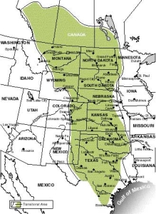
歴史家ウォルター・プレスコット・ウェッブは著書「ザ・グレートプレーンズ(The Great Plains)」の中で、北西ヨーロッパ人たちは米国の多くの地域に入植したが、特に3カ所の地域で厳しい「環境との戦い」を強いられた、と述べている。これらの地域では気候条件がヨーロッパの故郷とあまりにも似ていなかったため、ヨーロッパで開発された農作物を栽培できず、またヨーロッパで発達した定住様式も通用しなかったのである。その1つ目の出合いは、米国南東部の夏の高温多湿だった。2つ目に遭遇した相手は、乾燥した南西部と西部内陸部だった。そして、3つ目が、米国の中心部に広がる広大な草原地帯の連なりだったのである。
草原地帯の問題の1つは、強風、雹、竜巻を伴う激しい嵐が頻繁に発生するにもかかわらず、平均年間降水量が東部よりはるかに少ないことだ。冬には凍えるような突風を伴うブリザードで雪の大きな吹き溜まりができた。夏には熱くて乾いた風で土壌がカラカラに干上がり、時にはそれを巨大な土埃の雲に変えて飛ばしてしまうこともあった。
この地域では自然が供給する降水の量が乏しかったため、川筋沿い以外では樹木の栽培ができなかった。川の多くは狭く、時々しか水は流れなかった。東部から来た農民たちは作物の栽培や牧畜用の水が十分にあって、建物や柵や、暖房用の木材が豊富な環境に慣れていたため、「グレートプレーンズ」への入植に当たり、まったく違う気候条件に適応することを余儀なくされたのである。
 草原地帯は地形と植生が全米で最も変化に乏しい地域の1つである。オレゴン街道に沿って西に移動した初期の開拓者たちは季節が変わらないうちに太平洋沿岸に到着することができた。草原地帯の横断が非常に容易であったことも、その大きな理由である。この地域は自然地理的学的には全体が内陸低地の地域に含まれている。地下の堆積層はゆるやかに傾斜している。標高は東から西に向かって、ほとんど気づかないほど少しずつ高まっている。この地域の東端部分では標高はわずか500メートルだが、西部のコロラド州デンバーでは高さが1,500メートル以上にもなる。
自然地理学的に言うと、「グレートプレーンズ」の大部分を占めているのは、テキサス州南部から北上してネブラスカ州南部までの、この地域の西の縁に沿って広がる「ハイプレーンズ(High Plains)」である。砂質に富み、透過性の高い堆積物の厚いマントルに覆われたハイプレーンズの地形は全体的に平坦である。侵食を受けて局地的に起伏が激しくなっているのは、ネブラスカ州西部のプラット川沿いにあるスコッツブラフや、テキサス州北西部のレッド川沿岸のパロデュロ・キャニオンなど、川沿いの地域だけである。かつて更新世に最大の湖があったレークアガシ盆地もまた例外的に平坦な場所であり、ここには北のノースダコタ州とミネソタ州を流れるレッド川流域が含まれている。
しかし、この地域の全域が地形の変化に乏しいというわけではない。例外として最もわかりやすい例が、サウスダコタ州とワイオミング州にまたがるブラックヒルズである。ブラックヒルズは火成岩の侵食でできた広大なドーム型の地域であり、地質学的にも地形学的にも、西のロッキー山脈との関係が深い。テキサス州南部のエドワーズ高原には沿岸平野に隣接する南東部の縁に沿って激しい侵食で生じた大峡谷がある。ネブラスカ州の中部・北西部にあるサンドヒルズには、草に覆われた多数の砂丘が密集しており、そのうちの多くは高さ30メートル以上に及ぶ。これらの砂丘は更新世に大陸氷河の南側沿いに砂が吹き込んでできあがったものである。また、ネブラスカ州北部からミズーリ川に至るミズーリ高原は氷河作用を受けていないが、ここには堆積岩が風や雨に侵食されてできた極めて不規則な地形を持つバッドランズ(一部は国立公園)が広がっている。ミズーリ高原でも、ミズーリ川の北およびレークアガシ盆地の西の部分は氷河作用を受けており、平坦な場所もあるが、池やモレーン(堆積物の小山)など氷河作用の特徴が多く見られる。
農業によって、草原地帯の原生植物の多くが破壊されたが、この地域でも比較的降水量が多い東部地区(東部地区北部の年間降水量は60センチメートル以上、南部は90センチメートル以上になる)にはもともと、30センチメートルから1メートル程度という丈の高い草が生えたプレーリーが続いていた。「グレートプレーンズ」の西端には、草原性の草・プレーリーグラスに替わって、束生の草・パンチグラスが生えていた。バンチグラスは丈が低く分散して生える草で、「グレートプレーンズ」西部の半乾燥気候でも生育が可能だった。
プレーリーグラスの根系は深く発達して入り組んでいる。たいてい草の丈より長い根が地中へ伸びており、周囲の水分を有効に利用することができる。根系が入り組んでいるため、プレーリーを耕すのは格別に難しかった。初期の入植者たちは、20頭もの動物を使わなければ引けないような重い鋤(すき)を使って芝土を耕さなければならないことが多々あった。ヨーロッパ人が「グレートプレーンズ」に入植した初期のころには、この芝土を大きなレンガ状に切り、これを壁にした〝芝土の家〟を建てることもあった。
「グレートプレーンズ」に雨をもたらす最大の要因は、メキシコ湾から吹く暖かい湿った海洋性の熱帯の空気である。これは通常、ミシシッピ渓谷に沿って北上し、それから北東に向きを変えるため、「グレートプレーンズ」西部のほとんどをそれてしまう。その結果、西に行くにつれて平均降水量は著しく低下する。例えばカンザス州では、平均年間降水量は、湿潤な南東部の1050ミリメートルから、半乾燥気候の南西部の400ミリメートルまでと、場所によってまちまちである。
「グレートプレーンズ」で通常よりも多くの雨が降るのは、熱帯性の気団がメキシコ湾から北西に進み、「グレートプレーンズ」の上を通るときである。しかし、このような気流が頻繁に流れる訳ではないので、あてにはできない。「グレートプレーンズ」の農家にとって幸運なことは、降水量のおよそ4分の3が作物のよく育つ4月から8月に降る点である。
この地域で春と夏に雨が降るときには激しい雷雨になることがある。時には雹を伴う。雹は直径5センチ以上にもなり、重い穂をつけた小麦に壊滅的な被害を及ぼすことがある。「グレートプレーンズ」の南部と中西部では激しく雹が降ることがよくある。ネブラスカ州西部とワイオミング州南東部の一部は、1年間に雹が降る平均回数が全米で最も多い。
風速が時速350キロメートルを超えることがある竜巻は、「グレートプレーンズ」の暴風帯により、漏斗状の風が巻き起こる厳しい自然現象である。1回の竜巻が影響を及ぼす範囲は狭いが、「グレートプレーンズ」中部では竜巻の発生頻度が高いため、この地域の大きな災害発生原因の1つとなっている。
「グレートプレーンズ」では、風は功罪半ばする存在であった。晩春から夏にかけて、この地域の中部および南部で吹く風の風速は米国の内陸部でも最速級である。かつては、この風がこの地域の風力発電の効率を最大限に高めることに貢献したのは事実である。しかし、風がひっきりなしに吹くということは、この地域のほとんどの場所で植物の水分が抜け、発散する水分量が多いということにもなる。
チヌークと呼ばれる冬の風は、大西洋沿岸からの乾燥した比較的暖かい空気がロッキー山脈にぶつかって吹き上げられて発生する。風は「グレートプレーンズ」に吹き降りると、さらに暖まり、冬期にこの地域に頻繁に流れ込む冷たい大陸性気団よりもかなり暖かくなる。この太平洋からの空気が「グレートプレーンズ」西部から一時的に冷気団を押し出すと、気温が急激に上昇する。この興味深い現象も手伝って、「グレートプレーンズ」西部の標高の高い地域では、冬の気温が東端よりもわずかに高くなっている。
さらに、無霜期間の長さは年によって平均値よりも大きく変動する。年間気温と同様、北に向かうにつれてその変動幅は大きくなる。
「グレートプレーンズ」で最も甚大な被害を及ぼす気象現象の1つがブリザード(猛吹雪)で、これには、雪、風、寒さの要素がすべて含まれている。通常の西から東へ向かう暴風のパターンが崩れ、冷たい極地性気団がロッキー山脈に沿って「グレートプレーンズ」まで南下した冬にブリザードが発生する。ブリザードには強風、極寒、大量の降雪がつきものである。これが数日間続いて、冬期の平均降雪量の半分が1度のブリザードで降ってしまうこともある。この地域の牧場主は、冬期に家畜を屋外に出しておくのが普通なので、厳しいブリザードになると、動物たちが餌を近づくことができず、高い死亡率につながることもある。
ヨーロッパ人が入植する以前のアメリカン・インディアンは「グレートプレーンズ」のほんの一部でしか生活していなかった。主な経済活動は、狩猟、特にバッファロー狩りだった。ほとんどの部族は川に沿って半定住生活を行っていた。陸上を迅速に長距離移動する手段を持たなかったため(ヨーロッパ人入植前の北米大陸では、犬が唯一の家畜だった)、インディアンたちは信頼できる水の供給源である川の近くを長期間離れることができなかった。これは大きな問題だった。というのも、バッファローの大群が移動してしまうと、何週間もバッファローという食糧を入手できなくなったからである。
スペイン人が、自分たちで最初に開拓を進めた土地である「グレートプレーンズ」南部を離れるにあたり、何頭かの馬を残していった。この「贈り物」は「グレートプレーンズ」に住むインディアンの生活様式を劇的に変えた。19世紀の初め、米国人が「グレートプレーンズ」に到達すると、そこには世界史上最優秀と多くの人が呼んだ軽騎兵隊がいた。馬はこの草原の全域に普及していたので、インディアンたちはもはや水辺に縛り付けられることなく、バッファローの移動に自由についていった。
初期の米国人たちはこの地域を将来性がなく定住が難しい土地と見ていたが、これにも一理あった。樹木が生えていないということは、家や納屋、柵の建設や、燃料用として従来から使っていた材料が、農民たちの手に入らないことを意味した。水源も乏しく、川に水があるのは決まった季節だけのことが多かった。初期の開拓者たちは水路に沿って定住した。入植者たちが持ち込んだ作物は「グレートプレーンズ」では育たないことが多く、降水量が大きく変動するため、作物の出来は年によって大きく変わった。農業生産性も概して低く、ここよりずっと東の土地では十分と思われた65ヘクタールという農地の規模は「グレートプレーンズ」では狭すぎることがわかった。
こうした問題がいろいろ重なって、開拓の辺境地帯は「グレートプレーンズ」の東の境界線あたりで足踏みしてしまった。技術の進歩と土地所有形態の変化によって、この地域への入植が容易になるまで、開拓者たちは「グレートプレーンズ」を迂回して太平洋沿岸に行ってしまうことが多かった。
定住をためらっている間に別の経済形態がこの地域を席巻した。テキサス州南部にはスペイン人が、また、テキサス州東部には南部からの米国人入植者が大規模牧場経済をもたらしたのである。この大規模牧場は1867年から1885年までの時期にテキサス州から北へ広がっていった。
東部へ出荷するためと、広大で比較的開拓が進んでいない「グレートプレーンズ」に蓄えるために、ウシの大群がテキサス州南部から北のカンザス州にある終点の駅まで運ばれた。1880年までに、おそらく500万頭ものウシがこの地域に連れてこられた。
1880年代後半になると、粗放牧畜経済が急速に崩壊した。過剰放牧が広がったこと、中西部で牧畜が盛んになり中西部産の上質の牛肉と競争しなければならなくなったこと、国の経済が低迷したこと、1887年から1888年にかけて、悲惨な冬に見舞われたこと、そして「グレートプレーンズ」に農家が急速に流入したことなど、これらすべてが重なって、米国史の中でも短い粗放牧畜経済の時代が終わった。柵がなく、手入れも行き届いていない牧場は乾燥した「グレートプレーンズ」の西側に追いやられるか、まわりを柵で囲って閉鎖性を高めた牧畜方法に改めざるを得なかった。
農業の面では、1870年代に商用化された有刺鉄線が木材に替わる柵の材料として使われるようになった。しばらくの間は、ブロック状に切り取った〝芝土の家〟が住居として機能を果たしていたが、ほとんどの入植者たちは可能ならば一刻も早く木造家屋に建て替えていった。1870年代までには「グレートプレーンズ」全域を網羅する鉄道網の建設が始まっており、そのおかげで木材をこの地に運び込むことが出来るようになった。簡単な風車と機械式の井戸掘り機が開発されたことで、人間や動物の飲料用、さらに灌漑用に十分な量の水を自給することができるようになった。「グレートプレーンズ」で風車技術が広く採用された結果、その後、米国の多くの農村でも風車が使われるようになった。穀類栽培も機械化が進んだため、農家はより大規模な農場を経営し、少なくなった収穫高を補うことができるようになった。
そしてついに、この地の栽培条件に、よりよく適応した作物が農業経営に導入された。農民たちはこの土地の環境をどのように利用すべきかについて理解を深めるようになった。硬質の冬小麦がその最たる例である。ロシアからのメノー派信徒の移民によって最初に米国に持ち込まれたこの冬小麦は、それ以前に「グレートプレーンズ」で栽培されていた小麦よりもこの土地の乾燥した栽培条件にはるかによく適応していった。
今日では、「グレートプレーンズ」は米国随一の小麦生産地域であり、米国が世界一の小麦輸出国であるのは概してこの地域が豊富な農作物を生産していることが大きな要因である。
「グレートプレーンズ」の農業は大規模で機械化が進んでいるが、生産しているのはわずか数種類の作物で、そのうち最も重要なのが小麦である。冬小麦は秋に種蒔きする。冬の休眠期が来る前に小麦は数センチの長さに育つ。最も成長するのは、降水量が最も多く、乾いた夏の風が吹き出す前の春と初夏である。収穫は5月末から6月にかけて行われる。今日では、冬小麦は米国の大部分で栽培されているが、栽培が集中している地域はテキサス州北部からネブラスカ州南部までの「グレートプレーンズ」南部地域である。
主にサウスダコタ州中央部から北のカナダにかけて栽培されている春小麦は早春に種を蒔き、夏の終わりから秋に収穫する。冬の寒さが厳しくて、冬小麦であれば発芽期に枯れてしまうような地域に適している。
草原地帯で栽培される小麦のほとんどは灌漑を利用せず、乾地農法を使って栽培される。芝土を取り除き、蒸発を遅らせるため、非常に深く土に鋤を入れて耕す。特に「グレートプレーンズ」の北部で最も目立つのは、土中の水分を維持するために土地を耕したあと、1シーズン休ませておく休耕地方式が広く行われていることである。
6月1日ごろのテキサス州での冬小麦の収穫を皮切りに、コンバイン収穫隊が注文に応じて収穫をしながら次第に北へ移動する。ほかの作物の収穫を行う季節移民の農場労働者と違って、収穫隊は大勢でチームを組み、多くのコンバインやトラックを使って作業を行うことが多く、伝統的に賃金が高い。「小麦地帯」の大半にある農場は今では面積が400ヘクタールを超えている。ということは、自前のコンバインを購入できる小麦農家が増えているということである。しかし、「グレートプレーンズ」で収穫される小麦の3分の1は今でもコンバイン収穫隊が収穫している。
小麦の生産による利益をあげる上で大きな課題の1つは収穫物をこの地域に点在する大穀物倉庫へ迅速に移動させることが難しいことである。トラック輸送に加え、冬小麦の地域の一部では小型船輸送との競争が進み、鉄道は大きな町にある巨大な複合施設への輸送を優先して、田舎にある小さな穀物倉庫への輸送をやめてしまった。ほとんどの輸出用小麦は五大湖を経由するか、ないしは内陸部の水系やミシシッピ川を小型輸送船で運ばれる。
モロコシはここ数十年で「グレートプレーンズ」南部の主要作物の1つとして登場してきた。アフリカ原産のこの穀物は乾燥した生育環境に耐えられるため、暑くて乾燥したこの地域の南西部では冬小麦と同じくらい重要な作物となっている。テキサス州とネブラスカ州では、小麦よりもモロコシ用の農地のほうが多くなっている。モロコシのほとんどは家畜用飼料として使われる。
「グレートプレーンズ」の北部では大麦とオートムギが2番目に重要な作物であり、北米大陸の大麦のほとんどは、ノースダコタ州とミネソタ州のレークアガシ盆地で生産されている。北米で生産される亜麻種子も、ほとんどすべてこの地域で生育する。植物油のキャノーラ油の原料であり、飼料の製造に欠かせない材料であるヒマワリはミネソタ州とノースダコタ州のレッドリバー流域で経済的重要性が高まっている。
普通、米国で灌漑と言えば、遠い西部の乾燥地域での灌漑を考えてしまう。しかし、投資金額当たりの生産量の増加分として考えると、灌漑が生む利益は半湿潤地域や湿潤地域の方が大きい。それは、半湿潤地域や湿潤地域では灌漑用水を乾期の補足水源として使い、その地域ですでに栽培されている作物の収穫高を最大限に高めることもできるし、さもなければ、自然に得られる水分以上の水分量を必要とする作物を栽培する際に利用できるからである。
「グレートプレーンズ」には大規模な灌漑開発が欠かせない地域が多数存在する。このうち最も注目すべきなのは恐らくコロラド州とネブラスカ州からテキサス州にかけて広がる「ハイプレーンズ」である。この地域の地下にはオグララ帯水層がある。これは、25万平方キロメートルに及ぶ地域の地下に広がる巨大な自然の貯水槽であり、推定20億エーカーフィートの水が蓄えられている。(1エーカーフィートとは、0.4ヘクタールの面積を0.3メートルの深さまで満たすことができる灌漑用水の量である。)これは「化石水」であり、そのほとんどは100万年以上前にたまったものである。この帯水層地域のおよそ4分の1で灌漑が行われているが、利用されているのはほぼすべてオグララ水である。「ハイプレーンズ」は重要な農業地域の1つであり、全米で生産されるモロコシの5分の2、小麦の6分の1、綿花の4分の1がここで生産される。灌漑が行われているこの地域の農地の生産量は、灌漑を行っていない近隣地域と比べて、小麦で45%、モロコシで70%、綿花で135%多くなっている。1950年以降、地下水の汲み上げは3倍以上に増加し、年間2,000万エーカーフィートを超えている。
20世紀初め、テキサス州ラボックを中心とする地域はめざましい綿花生産の中心地となった。「ハイプレーンズ」南部の大部分の地下に広がる水を含んだ砂地を掘削した井戸から水を汲み上げて利用する灌漑農法が、次第に初期の乾地農法に替わって使われるようになった。今日では、この地域は米国で最も重要な綿花の栽培地になっている。この地域では、5万カ所以上の井戸が灌漑用水を供給している。
「グレートプレーンズ」で2番目に重要な灌漑地域はコロラド州北東部にあり、テンサイ(甜菜)を主な特産物としている。この地域では長い間、井戸とサウスプラット川の水を使って灌漑が行われてきた。連邦政府が建設費をまかなっており、灌漑利用者は使った水の料金を支払う。現在の灌漑用水ではもはや需要を満たすことができなくなっているため、連邦政府はビッグ・トンプソンリバー開発プロジェクトに資金を提供した。これは、ロッキー山脈の支脈であるフロント山脈の西斜面から東斜面へ、さらにその向こうの灌漑農地へと、水を輸送することを目的とするものである。このプロジェクトの最も際立った技術的特徴はロッキー山脈国立公園内の山脈分水嶺の下1,200メートルに、長さ33キロメートルのトンネルを建設した点である。
「グレートプレーンズ」の貯水プロジェクトで最大規模のものはミズーリ川流域プロジェクトである。これは、2つの異なる状況から必要とされた。1つはカンザスシティやセントルイスを含むミシシッピ川の下流域に住む人々が、効果的な治水システムを必要としていたという事情である。この地域の年間降水量は約1000ミリメートルである。これとは対照的に、ミズーリ川上流域、特に南北ダコタ州とミネソタ州に住む人々は、灌漑用に十分に水を供給するシステムを必要としていた。こうした必要に迫られて生まれたシステムは、ミズーリ川上流に作られた一連の大きな土堰(どせき)ダムと、多くの支流に建設された多数のダムで構成されている。
これらのプロジェクトや、その他多数の小規模灌漑プロジェクトや井戸によって、この地域の農業の多様性は著しく高まった。「グレートプレーンズ」の中部と北部の全域では、アルファルファ(ムラサキウマゴヤシ。西部で最も重要な牧草)を栽培する灌漑農地が最も多くなっている。コロラド州東部とカンザス州西部のアーカンソー川流域、コロラド州北東部のサウスプラット川沿いでは、テンサイが重要な作物となっている。アーカンソー川流域の農家は自分たちが生産するカンタループ系メロンの品質に誇りを持っている。ネブラスカ州の南部から中央部にかけてでは井戸水を使って行う灌漑を利用したトウモロコシが主要作物の1つとなっている。
「グレートプレーンズ」の堆積物には、石油、天然ガス、石炭などのエネルギー資源が大量に含まれている。南にある主な油田や天然ガス田は従来から米国有数の石油・天然ガス供給地に数えられている。テキサス州の西部、オクラホマ州、カンザス州にまたがるパンハンドル・ガス田は世界最大の天然ガスの供給地である。これら3州は石油の主要産出地でもあり、近年の開発によってワイオミング州も主要石油産出地の仲間入りをしている。
ノースダコタ州は豊富なエネルギー資源、特に軟炭に恵まれているが、米国最大の石炭産出州はワイオミングである。1996年のワイオミング州産石炭は10億6,000万トンであり、全米層産出量の26%を占めていた。
デンバー州には石油による莫大な富が集まってきている。ネブラスカ州アライアンスは1975年から1980年までの5年間で規模が2倍近くに膨れ上がったが、それはワイオミング州の炭田から石炭を東に運ぶバーリントン・ノーザン鉄道の要所にあるからである。ワイオミング州パウダー川流域で行われる採炭活動の中心に位置する最大の町、ジレットの人口は、10年間で5倍に増加した。
1970年代初めに、米国で大気浄化法が成立した。これを受けて、西部産の概して硫黄分が少ない石炭の需要が増えた。厳しい大気汚染防止関係法の規定を満たす低硫黄の亜瀝青炭が「グレートプレーンズ」北部の地表近くに少なくとも1,000億トン眠っている。これは、全米の現在の消費量を125年間まかなえる量である。地表から2,000メートル以内に、合計1兆5,000億トンの石炭があるとみられている。この地域の経済構造はすでに変化しつつあり、農業と牧畜の重要性が低下している。
「グレートプレーンズ」の中のほとんどの場所で、過去50年間に人口が減少、もしくはよくても伸び悩みという状況が当たり前になっている。この地域には明らかに都市部というものが不足しており、レクリエーション地域としての可能性もほとんどなく、最近までは大規模な天然資源の開発もほとんど行われていなかった。この地域の人口増加は「グレートプレーンズ」の周辺近くにある比較的大きな町に集中している。一方、より小規模なコミュニティや農村地域のほとんどは人口の流出を経験しており、しばしば人口減少が起きている。
この地域の多くは周辺部より少し外にある主要都市部から恩恵を受けている。そのうち主なものは、カンザスシティ(ミズーリ州)とミネアポリス・セントポール(ミネソタ州)である。デンバー(コロラド州)、ダラス・フォートワースとサンアントニオ(ともにテキサス州)といったこの地域最大の都市はすべて周辺部にある。デンバーはこの地域のビジネスセンターであるだけでなく、「グレートプレーンズ」北部や、西部内陸部のエネルギー資源開発を対象とする金融活動の中心地である。ダラスも南西部地域で最も大きなビジネスセンターの1つであり、まるで湿潤な東部の都市のようである。一方ダラスの50キロメートル西に位置し、より規模が小さいフォートワースは牧畜と家畜飼育の中心であり、明らかに「グレートプレーンズ」の一部に属している。サンアントニオは、テキサス州南部で最大の商業の中心地であり、また複数の主要軍事基地もここにある。
地域に水道、電力、放送を供給する多くの幾分小さな中心地(オクラホマ州タルサやネブラスカ州オマハのような都市)もまた、周辺部にある。「グレートプレーンズ」の周辺地域に集まる都市のサービスエリアは、東西に広がる傾向があり、地域全体をカバーしている。
「グレートプレーンズ」のほとんどの都市は、輸送の中心地として始まり、鉄道網に沿って並んでいるのが普通である。繁栄をとげた都市はある程度の輸送サービス機能を維持しているが、それだけでなく地域の市場センターとしてもその地位を確立している。特殊な地域条件がプラスの効果を生んでいる町もある。例えば、オクラホマシティやタルサは石油生産の重要な中心地である。カンザス州ウィチタは小型航空機製造の中心地である。
過去30年間に「グレートプレーンズ」にある多数の小さな町で牛肉加工産業が盛んになってきている。以前、この産業は大きな複合施設を持つ中西部に集中していた。だが、食肉解体処理業の技術の変化、「グレートプレーンズ」での飼育場の増加、そして取引方法の多様化によって、次第に、この地域の小さな町の新しい飼育場近くに小規模の加工場を持つ方が経済的になったのである。
「グレートプレーンズ」の当初の輸送経路は、この地域への供給のためではなく、地域を横断して他の地域へ運ぶことを目的に建設された。従って、主要高速道路や鉄道のほとんどはこの地域を東西に突っ切っており、南北に伸びているルートは数少ない。
*上記の日本語文書は参考のための仮翻訳で、正文は英文です。
The Great Plains and Prairies
(The following article is taken from the U.S. Department of State publication, An Outline of American Geography.)
The Great Plains and Prairies
By Stephen S. Birdsall and John Florin
The historian Walter Prescott Webb, in his book The Great Plains, suggested that the northwest Europeans who settled much of the United States faced three great "environmental encounters" – areas where climatic conditions were so unlike those of their home region that the agricultural crops and settlement patterns developed in Europe were inappropriate. The first of these encounters was with the high summer temperatures and humidity levels of the Southeast. The second was the arid Southwest and interior West. The third was the great continuous grasslands located astride the center of the country.
Among the problems on the grasslands, average annual precipitation was much less than in the East, although violent storms accompanied by high winds, hail, and tornadoes were common. Blizzards with wintry blasts intensifying the cold drove the snow into immense drifts. The hot, dry winds of summer parched the soil and sometimes carried it away in great billowing clouds of dust.
The region's sparse natural water supply would not support tree vegetation except along the stream courses. Many of these streams were small and flowed only intermittently. Eastern farmers, accustomed to a plentiful supply of water for crops and animals, as well as ample wood for building, fencing, and heating, had to adapt to quite different conditions in their attempts to settle the Great Plains.
THE PLAINS ENVIRONMENT
The topography and vegetation of the grasslands is among the least varied to be found anywhere in the United States. Early settlers following the Oregon Trail could reach the Pacific coast in one season of travel, in part because the grasslands were so easy to cross. The region lies entirely within the interior lowlands physiographic province. The underlying sedimentary beds dip gently. Elevation increases gradually, almost imperceptibly, from east to west. Along the eastern margin, the elevation is only 500 meters, whereas in the west, Denver, Colorado, claims an altitude of more than 1,500 meters.
Physiographically, the largest portion of the Great Plains is the High Plains stretching along the western margin of the region from south Texas northward to southern Nebraska. Covered by a thick mantle of sediments that are often quite sandy and extremely porous, this section is generally flat. Only along streams such as at Scottsbluff on the Platte River in western Nebraska or at Palo Duro canyon on the Red River in northwest Texas has erosion resulted in substantial local relief. The Lake Agassiz Basin, formerly occupied by the largest of the Pleistocene lakes, is another exceptionally flat area and includes the valley of the Red River of the North in North Dakota and Minnesota.
Not all portions of the region are so unvarying topographically. The most obvious exception are the Black Hills of South Dakota and Wyoming. A large, dome-shaped area of eroded igneous rock, the Black Hills are associated both geologically and topographically with the Rocky Mountains to the west. In southern Texas, the Edwards Plateau is heavily eroded into a canyonlands landscape along its southeastern margin where it is adjacent to the coastal plain. In central and northwestern Nebraska, the Sand Hills offer a dense, intricate pattern of grass-covered sand dunes, many of which are well over 30 meters high. The dunes were created by sand blowing along the southern margins of continental glaciers during the Pleistocene. Badlands topography -- extremely irregular features resulting from wind and water erosion of sedimentary rock -- is widespread on the unglaciated Missouri Plateau from northern Nebraska northward to the Missouri River. North of the Missouri River and west of the Lake Agassiz Basin, the glaciated Missouri Plateau, although sometimes flat, is covered with ponds, moraines, and other glacial features.
Although agriculture has destroyed much of the original grasslands vegetation, the moister eastern portions (areas with more than 60 centimeters of annual precipitation in the north or more than 90 centimeters in the south) were originally a continuous tall-grass prairie, where grasses grew between 30 centimeters and 1 meter in height. Along the western margins of the Plains, prairie grasses gave way to bunch grasses -- shorter, more separated grasses could succeed in the semiarid conditions of the western Plains.
The prairie grasses have developed deep, intricate root systems that commonly extend much deeper into the soil than the grass blades reach above, allowing them to utilize available water. The tangled root system made the prairies exceptionally difficult to plow. The first settlers often had to employ heavy plows pulled by as many as 20 animals to break the sod. The prairie sod could also be "cut" into large bricks used in the construction of sod houses during the early period of Plains' settlement by Europeans.
The warm, moist tropical maritime air flowing in from the Gulf of Mexico, the prime contributor of moisture to the Plains, commonly curves up the Mississippi Valley and then moves northeast, missing much of the western Great Plains entirely. One result of this pattern is the marked westward decline in average precipitation amounts. In Kansas, for example, average annual precipitation varies from a moist 105 centimeters in the southeast to a semiarid 40 centimeters in the southwest.
Periods of higher than normal precipitation on the Great Plains result when tropical air masses move northwestward from the Gulf of Mexico, which brings these air masses over portions of the Plains. This provident current is far from dependable, however. Fortunately for the Plains farmer, about three-quarters of the precipitation falls during the period of more rapid crop growth, from April to August.
Some of the region's spring and summer precipitation comes in the form of violent thunderstorms. Hail is occasionally a product of these storms. These frozen pellets, sometimes measuring more than 5 centimeters in diameter, have the power to devastate a crop of mature, top-heavy wheat. Much of the southern and west-central Plains experiences frequent hail storms, with parts of western Nebraska and southeastern Wyoming leading the continent in average annual hail frequency.
Tornadoes, which can have funnel wind speeds in excess of 350 kilometers per hour, are another violent result of these storm systems of the Great Plains. Although the area affected by any one funnel is small, the frequent occurrence on the central Plains makes tornadoes a significant regional hazard.
Wind has been a mixed blessing on the Great Plains. Late spring and summer wind velocities on the central and southern Plains are among the highest in interior America. In the past, this served to maximize the efficiency of windmills in the region. However, the persistent winds also mean that the amount of moisture evaporated and transpired by plants is high across much of the region.
The chinook, a winter wind, occurs when dry, relatively warm air from the Pacific Coast pushes over the Rocky Mountains. As it descends onto the Great Plains, it warms still further and is much warmer than the cold, continental air mass commonly found over the region in winter. The Pacific air temporarily pushes the cold air from the western Plains, and a rapid, dramatic temperature rise results. Partly because of this interesting phenomenon, winter temperatures along the higher western area are slightly warmer than along the eastern edge of the Plains.
In addition, the length of the frost-free season varies widely around the average from year to year. As with annual temperature range, the variation increases as one moves northward.
Snow, wind, and cold are all part of one of the most devastating weather elements on the Plains: the blizzard. A blizzard occurs in winter when a very cold polar air mass pushes southward along the Rocky Mountains and onto the Plains, breaking the usual west to east storm pattern. High winds, intense cold, and considerable amounts of snow are associated with these storms. A blizzard can last for several days and bring half of the average winter snowfall. Because Plains ranchers usually leave their livestock outdoors during the winter, a severe blizzard may block an animal's access to food and result in high animal mortality.
SETTLEMENT PATTERNS
The pre-European occupation of the Plains by American Indians was limited. Hunting, particularly for buffalo, was the primary economic activity. Most tribes lived along streams in semipermanent settlements. With no means of rapid long-distance overland movement (the dog was the only domesticated animal in pre-European North America), the Indians could not leave the dependable water supplies of the streams for any long period. This was a substantial problem, for the migration of the great buffalo herds often took this food source far away from the settlements for many weeks.
When the Spanish departed from the southern Plains following their initial explorations, they left some of their horses behind, a "gift" that dramatically altered the lifestyle of the Plains Indians. By the time Americans reached the Plains in the early 19th century, they found what many have called the finest light cavalry in world history. The horse had diffused throughout the grasslands, and the Plains Indians, no longer restricted to the waterways, freely followed the buffalo migration.
The early American perception of the region as an unpromising and difficult place to settle was not totally wrong. The lack of trees meant that farmers had none of the traditional material used for the construction of houses and barns, for fencing, or for fuel. Water sources were scarce; often rivers and streams had only a seasonal flow. Those who arrived early settled along these waterways. The crops that settlers brought with them to the Plains often failed, and crop success varied greatly from year to year as precipitation amounts fluctuated widely. Agricultural production rates were also generally lower, and the 65-hectare farm size that seemed so adequate farther east proved to be too small on the Great Plains.
The settlement frontier hesitated along the eastern boundary of the Plains partly as a result of these problems. Settlers tended to bypass the Plains for the Pacific Coast until technological and land ownership changes made Plains settlement more inviting.
During this hesitation, an alternative economic system swept across the region. An extensive ranching economy had been introduced into south Texas by Spaniards and into east Texas by American settlers from the South. This economy spread from Texas northward during the period from 1867 to 1885.
Great herds of cattle were driven northward from south Texas to railheads in Kansas both for shipment east and to stock the huge, relatively unsettled Plains region. By 1880, perhaps 5 million head of cattle had been moved.
The open-ranching economy collapsed rapidly in the late 1880s. Widespread overgrazing, competition from the superior beef of expanding cattle-raising operations in the Midwest, a slipping national economy, a disastrous winter in 1887-1888, and a rapid influx of farmers onto the Plains combined to end this short period of American history. The open-range, unimproved ranches were pushed to the drier western side of the Plains or were forced into a more restrained fenced operation.
On the agricultural frontier, barbed wire, developed commercially in the 1870s, provided an effective alternative fencing material to take the place of the missing wood supply. For a time, dwellings constructed of sod provided adequate housing. Nevertheless, most settlers replaced them as soon as possible with frame homes. Lumber was brought in by the railroads, which were under construction all across the Plains by the 1870s. The development of a simple windmill and mechanical well-drilling devices meant that sufficient water could be obtained locally for humans and animals, as well as for irrigation. It was the widespread adoption of windmill technology on the grasslands that led to its subsequent acceptance across most of rural America. Grain farming also became increasingly mechanized, enabling farmers to operate larger farms and thus compensate for lower yields.
Finally, crops that were better adapted to the growing conditions of the region were introduced into the agricultural system, and farmers began to improve their understanding of how to use the Plains environment. Hard winter wheat is perhaps the best example. First brought to the United States by Mennonite immigrants from Russia, it was far better adapted to the dry growing conditions of the Great Plains than the wheat strains grown there earlier.
Today, the Great Plains is America's premier wheat-producing region, and it is largely on the abundance of Plains agriculture that the United States is the world's top wheat exporter.
PLAINS AGRICULTURE
The agriculture of the Great Plains is large scale and machine intensive, dominated by a few crops, the most important of which is wheat. Winter wheat is planted in the fall. Before the winter dormant season sets in, the wheat stands several centimeters tall. Its major growth comes in the spring and early summer, when precipitation is at a maximum and before the onset of the desiccating winds of summer. It is harvested in late May and June. Today, winter wheat is grown across much of the United States, but its zone of concentration is the southern Plains from northern Texas to southern Nebraska.
Spring wheat – grown primarily from central South Dakota northward into Canada – is planted in early spring and harvested in late summer or fall. It is suited to areas of winters so severe that germinating winter wheat would be killed.
Most grasslands wheat is grown using dry farming techniques, without irrigation. The soil is plowed very deeply to break the sod and slow evaporation. Most visually obvious, especially in the northern Plains, is the widespread use of fallowing, where the land is plowed and tilled but not planted for a season to preserve moisture.
Beginning around June 1 with the winter wheat harvest in Texas, custom combining crews gradually follow the harvest northward. Unlike migrant farm laborers harvesting other crops, these people, often in large crews that use many combines and trucks, have traditionally been well-paid agricultural workers. The farms in most of the "Wheat Belt" now exceed 400 hectares, which means that more wheat farmers can now afford their own combines. Still, probably one-third of all Great Plains wheat is harvested by custom combining crews.
A major problem with profitable wheat production is the difficulty of moving the harvest rapidly to storage in the large grain elevators that dot the Plains. Competition from truck hauling and, in parts of the winter wheat region, barge transport has encouraged the railroads to abandon many small country grain elevators in favor of much larger complexes usually in larger towns. Most export wheat moves through the Great Lakes or in barges down the inland waterway system and the Mississippi River.
Sorghum has emerged as a major crop on the southern Plains in recent decades. Able to withstand dry growing conditions, this African grain now equals winter wheat in importance on the hot, dry southwestern margins of the Plains. Both Texas and Nebraska now have more land in sorghum than in wheat. Most of the grain sorghum crop is used as stock feed.
On the northern Plains, barley and oats are major second crops, with most of the continent's barley crop coming from the Lake Agassiz Basin of North Dakota and Minnesota. Nearly all flaxseed produced in North America also is grown in the northern Plains. Sunflowers, a source of the vegetable oil canola and important ingredients in many livestock feeds, are rapidly increasing in importance in the Red River Valley of Minnesota and North Dakota.
WATER CONTROL AND IRRIGATION
Irrigation in the United States is usually associated with the dry region of the far West. Yet the benefits derived from irrigation may be higher in many semihumid or even humid areas – in terms of the level of increased production per dollar invested – because irrigation water may be used either as a supplement in dry times to maximize yields for crops already grown in the area or to grow crops for which the available moisture is not quite sufficient.
There are a number of Great Plains areas where large-scale irrigation developments are important. Perhaps the most noteworthy of these is on the High Plains from Colorado and Nebraska to Texas. The area is underlain by the Oglala aquifer, a vast underground geologic reservoir under 250,000 square kilometers of the area that contains an estimated 2 billion acre-feet of water. (An acre-foot is the volume of irrigation water that covers 0.4 hectares to a depth of 0.3 meters.) This is "fossil" water, much of it deposited more than a million years ago. About a quarter of the aquifer's area is irrigated, almost entirely with Oglala water. The High Plains is a major agricultural region, providing, for example, two-fifths of America's sorghum, one-sixth of its wheat, and one-quarter of its cotton. Irrigated lands here produce 45 percent more wheat, 70 percent more sorghum, and 135 percent more cotton than neighboring nonirrigated areas. Groundwater withdrawals have more than tripled since 1950, to more than 20 million acre-feet annually.
Early in the 20th century, the area centered on Lubbock, Texas, became a significant region of cotton production. Irrigated farming, using water from wells drilled into the water-bearing sands that underlie much of the southern High Plains, gradually replaced the early dry-farming approach. Today, the region is the most important area of cotton production in the United States. More than 50,000 wells supply irrigation water in the area.
The second major irrigated area on the Plains is in northeastern Colorado, with sugar beets the primary specialty crop. The area has long been irrigated from wells and from the waters of the South Platte River. The federal government covers the cost of construction, and those who use irrigation pay for the water. Because these waters are no longer adequate to meet demands, the government funded the Big Thompson River project, which is designed to carry water from the west slope of the Front Range of the Rocky Mountains to the east slope and the irrigated lands beyond. The most striking technological feature of this project is a 33-kilometer tunnel, lying 1,200 meters below the Continental Divide in Rocky Mountain National Park.
The largest of the water impoundment projects on the Plains is the Missouri Valley project. The project was an outgrowth of two different sets of needs. People living at the lower end of the Mississippi Valley, including those in Kansas City and St. Louis, needed an effective system of flood control. About 100 centimeters of precipitation falls on this area each year. In contrast, people in the upper Missouri Valley, especially the Dakotas and Montana, needed a system to provide ample water for irrigation. The resultant system is composed of a series of large earth-fill dams on the upper Missouri, as well as numerous dams on many of the tributaries of the river.
These and many other smaller irrigation projects and individual wells have allowed a great expansion in the diversity of Plains agriculture. Throughout the central and northern Plains, alfalfa – the premier hay crop of the West – claims the largest irrigated hectarage. Sugar beets are important in the Arkansas River Valley of eastern Colorado and western Kansas, and along the South Platte in northeastern Colorado. Arkansas valley growers also take great pride in the quality of their cantaloupes, while corn, usually irrigated from wells, is a major crop in south-central Nebraska.
NATURAL RESOURCES
The sediments of the Great Plains contain major reserves of energy resources -- petroleum, natural gas, and coal. To the south, major petroleum and natural gas fields are traditionally among America's leading suppliers of these products. The Panhandle Field, encompassing western portions of Texas, Oklahoma, and Kansas, is the world's leading supplier of natural gas. The same three states are major petroleum producers, and recent developments have also added Wyoming to this group.
North Dakota can boast of sizable energy resources, mostly in the form of soft coal, but it is Wyoming that is the leading coal-producing state in the United States. In 1996, Wyoming mines provided 26 percent of the total U.S. coal output, or 1.06 billion tons.
Denver has become a focus of considerable petroleum-based wealth. Alliance, Nebraska, nearly doubled in size between 1975 and 1980 because of its location on the Burlington and Northern rail line, which carries coal eastward from the Wyoming fields. Gillette, the largest town in the center of Wyoming mining activity in the Powder River basin, saw its population increase by a factor of five in a decade.
The passage of the Clean Air Act in the United States in the early 1970s provided an important boost for the West's generally low-sulphur coal. At least 100 billion tons of low-sulfur sub-bituminous coal that meets strict antipollution laws can be found near the surface in the Northern Plains, an amount equivalent to that needed for 125 years at current levels of national consumption. Within 2,000 meters of the surface, the total is perhaps 1.5 trillion tons. Already the structure of the regional economy is shifting, with agriculture and ranching declining in importance.
POPULATION PATTERNS
Population decline, or at best stagnation, has become the accepted standard across much of the Great Plains during the past 50 years. The region has a decided lack of urban centers, major recreational potential is minimal, and, until recently, there were few important natural resource developments. Regional population growth is concentrated in the larger cities near the margins of the Plains, while most smaller communities and rural areas experience outmigration and often population decline.
Much of the region is served by major urban centers that are found somewhat beyond the peripheries of the Plains. Chief among these are Kansas City (Missouri) and Minneapolis-St. Paul (Minnesota). Denver (Colorado), Dallas-Fort Worth (Texas), and San Antonio (Texas), the largest American cities on the Plains, are all peripheral. Denver is a regional office center as well as the focus of financial activity for energy resource development on the Northern Plains and in the Interior West. Dallas, also a dominant regional office center for the Southwest, seems more of a city of the humid east, whereas the smaller Fort Worth – 50 kilometers to the west – is a ranching and stockyard center that is clearly part of the Plains. San Antonio is the largest commercial center in south Texas plus the home of several major military bases.
Many of the somewhat smaller centers serving the area are also peripheral – cities such as Tulsa (Oklahoma) and Omaha (Nebraska). The service areas of the cities grouped around the edges of the Plains tend to be elongated east-west zones that cover the region.
Most towns on the Plains began as transportation centers, commonly strung out along the railroads. Those that have prospered maintain some transport service function, but they have also become established regional market centers. Some are also supported by special local conditions – Oklahoma City and Tulsa, for example, are important petroleum centers. Wichita, Kansas, is a manufacturing center for small aircraft.
The beef processing industry has expanded into many smaller Plains communities during the last three decades. Formerly, the industry had been concentrated in the Midwest, where facilities were large and complex. Changing technology in the slaughter industry, the growth of feedlots on the Plains, and more diversified marketing patterns gradually made smaller plants located near the new feedlots of smaller Plains towns more economical.
Transportation routes on the Plains were originally built to cross the area rather than to serve it. Thus, most major highways and railroads pass east-west across the Plains, with few lines running north-south.
[Stephen S. Birdsall is dean of the College of Arts and Sciences at the University of North Carolina at Chapel Hill. He holds a master's and a doctoral degree in geography from Michigan State University and is the co-author of four books and atlases, including Regional Landscapes of the United States and Canada.]
[John Florin is chair of the geography department at the University of North Carolina at Chapel Hill. He holds a master's and a doctoral degree in geography from Pennsylvania State University. His recent publications include Atlas of American Agriculture: The American Cornucopia with Richard Pillsbury and Regional Landscapes of the United States and Canada with Stephen S. Birdsall.]