
国務省出版物
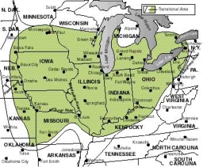
米国の地理の概要 – 農業の中核地域
「農業の中核地域(Agricultural Core)」は、様々な習慣や態度、伝統的な生計手段への反応、地域内のほかのグループとの相互作用の積み重ねなどが渾然一体となって成立している文化地域である。基本的に「農業の中核地域」は独特の農業様式に彩られた米国の小さな町や田園である。この地域の人々は政治的・社会的には慎重だが独立心に富んでいる。過去の成功例を安心して踏襲し、大都市や地域と地域との間に挟まれた境目の場所で見られるような、変化への圧力にはあまりさらされていない。この地域はよく知られている「ミドル・アメリカ(Middle America=アメリカの中西部)」という言葉で呼ばれている。
「農業の中核地域」には、19世紀末ごろまで、北西ヨーロッパ系を中心とする外国人が多く移り住んだ。その後は東欧系や地中海諸国からの移民が移住してきたが、農業に適した土地はすでに占有されていたため、彼らは近くの「製造業の中核地域」に属する大都市圏に定住した。
 アパラチア山脈を越えて内陸平野の東部にやってきた入植者たちは生き残って生計を立てることに必死だった。その地域に昔から住むアメリカン・インディアンの抵抗と、よくある自然のむら気な変化をのぞけば環境は入植に適していた。オハイオ州、インディアナ州、そしてミシガン州南部はその大部分が様々な広葉樹が生い茂る森林に覆われていた。東部からの経験豊かな移住者たちはこれらの木を見れば、最も質の高い土壌がどこにあるかがわかった。また、これらの木から大量の燃料や建材を地元で調達することもできた。森林内の狭い空地や湿地はインディアナ州の西端近くやイリノイ州やウィスコンシン州南部へと入り込むにつれて広くなり、数も増えて頻繁に現われた。川沿いや、丘陵地を除けば、イリノイ州、アイオワ州、ミネソタ州南部とミズーリ州北部の一部には、森林面積と同じくらいの開けた草原地帯があった。入植者がアイオワ州北部・中央部や西部に至る頃には、うっそうとした森林地帯は、何キロメートルも後方にあった。
一般的に、森林があるということは、作物の生育に適した水分があるということを意味する。「農業の中核地域」全域の年間降水量は、北西部、ミシガン州、ウィスコンシン州東部の少数の地区を除けば、平均750ミリメートル以上である。この地域の南端部になると、降水量は時に1000ミリメートルを超える。しかも重要なことに、雨が降るのは概して耕作期間にあたる4月末から11月初めまでである。もう1つ、植物の生育にとって重要なのは平均降水量に10年間ほとんど変動がないという点である。夏の雨はしばしば、激しい雷雨になる。時には雹や強風を伴い、作物に被害を与えることもあるが、このような場合でもこの地域の農家は、吹きさらしの平野にある農家よりも経済的な大打撃を受ける可能性が低い。
米国のほかの内陸地域と同様、「農業の中核地域」は気温の差が大きいのが特徴である。冬の最低気温は緯度がずっと北の地域と同じくらいまで下がることが多い。同様に、夏の気温は、緯度がずっと南の地域と同じくらいまで上がる。例えば、この地域の中心に近いイリノイ州ピオリアの平均気温は1月が零下4℃なのに、7月は24℃である。
農家にとっては、夏の気温が高いということは作物の生育が促進されるということである。しかし平均的な非農家居住者にとっては昼夜を問わない暑さと湿度の高さに苦しむ夏になりかねない。「農業の中核地域」の冬は長くてどんよりと曇ることが多く、いやになるほど寒い。
「農業の中核地域」の気候的極相がそもそも農業に非常に適しているが、この地域の適度な起伏のある地形もいかにも農業向きである。地形は穏やかにうねり、まっ平らであったり険しかったりする場所はほとんどない。起伏が穏やかであるということはこの地域全体の大部分が農耕に使えることを意味する。また畑も十分に管理が行き届く広さである限り、著しく侵食される心配もないということでもある。
農業機械が開発されると、この地域の全域で使用可能となってきた。果てしなく続くなだらかな隆起に、時折小丘や小川がアクセントをつけている地形は植林地や放牧地を維持するのにうってつけだった。また、なだらかな隆起のせいで土壌の排水も良好で、ほとんどの場合、湿地は狭い地域に限られていた。
「農業の中核地域」の特徴となる地形は、概して「メガロポリス」のいくつかの港を作った同じ氷河作用でできたものである。「カナダ楯状地」の中心から巨大な氷の塊が外に広がると、氷の重量と動きによって、柔らかな堆積性の小山の頂上が削り取られた。このようにして削られた岩屑が氷床の中に入り込み、徐々に沈殿して、一部は頂上を切り取られた丘の間の谷間を部分的に埋めていった。その後氷河の前面が後退すると、この岩屑でできた長く続く低い丘がそのまま残り、後に人類が出現する頃には起伏がわずかに大きくなった何本かの丘陵の連なる地形となっていた。(二つの文をつなげる)氷河の後退によって放出された大量の融氷水の浸食作用によって、ミシガン湖から南西に流れるイリノイ川や、オンタリオ湖から東と南に伸びるモホーク・ハドソン川の流域など、主要河川がいくつか作られた。この時代には五大湖の地表標高が高かったため、シカゴの南、ミシガン州のサギノー湾の南、そしてオハイオ州トレドからインディアナ州フォートウェインまで広がるブラックスワンプ・レイクプレーンを含む広大な地域は―いまは陸地だが―水面下にあった。
ケンタッキー州北部から中央部にかけての地域に広大な盆地がある。このブルーグラス盆地またはブルーグラス平野と呼ばれる盆地については、「農業の中核地域」の一部ではないと見る向きも多い。だが、この盆地があることによって、なだらかな起伏が続き生産性の高い農業が行われている地域がアパラチア高原の端まで続く結果になっている。この地域の低くてなだらかな起伏は、主に、厚い石灰岩の岩盤の上に形成された残留性のカルスト地形でできている。石灰岩は水流の中で次第に溶解し、表面の特徴の多くが消えてしまう。また、石灰岩は地中で分解され、時には何マイルにも及ぶ鍾乳石や石筍の洞窟を形成する。この盆地の南西にある(巨大鍾乳洞の)マンモスケーブ国立公園は、おそらくこの地域で最も有名だろう。
「農業の中核地域」の土壌は質がよく、しばしば平均以上だが、総じてずば抜けて良質とも言えない。イリノイ州中央部とウィスコンシン州の南部から中央部にかけての地域は例外だが、アイオワ州中央部から東側の土壌はアルフィゾルである。この土壌は適度な水分がある場所で通常針葉樹林または混合林の下に形成される。この層土は薄く、腐食質に乏しいが、農業に大切なミネラルを含んでいる。一般的に言って、「農業の中核地域」東部を広く覆う土壌の生産性を保つ上で必要なのは、十分な鋤起こしと、何らかの輪作、そして農業用石灰の散布だけである。
この地域の西側の土壌とイリノイ州の大部分の土壌はモリソルである。これはあらゆる土壌の中で最も肥沃で、そのままで穀類の生産に適している土壌に数えられている。モリソルは木に覆われた森林ではなく草地の下に形成されたものである。土壌の色は、濃い茶色から非常に高い有機物含有率を示す黒に近い色まで様々である。この土壌は概して深く、表層は50センチメートルから150センチメートルに及ぶ。
上記2種類の広い分類の土壌以外の主なものが2つある。1つは大きな河川の流域やかつて湖の底だった場所に見られる沖積土で、もう1つは湿地土壌である。どちらのタイプも潜在的には肥沃だが、特別な処置を必要とすることが多い。
「農業の中核地域」の自然環境は輸送に大いに役立った。鉄道が敷設され、道路網が隅々まで発達する以前からこの地域内は河川や湖でつながっていたため、物を経済的かつ容易に東部沿岸の人口密集地域や主要国際貿易港へ輸送することができた。
この地域への入植者の移動は大きな水路沿いが最も時期的に早かった。五大湖南部、オハイオ川、ミシシッピ川の東にあるイリノイ川、ウォバッシュ川、ウィスコンシン川、そしてカンザスシティに向かって西へ流れるミズーリ川などはすべて入植者の進出と彼等の農産物を出荷するための主要ルートになった。五大湖東部からはモホーク・ハドソン川ルートを通って、ニューヨーク市まで直接積荷を運ぶことができた。内陸部の水系はすべてミシシッピ川に流れ込んでおり、どこでもほとんど障害もなしに小型船やはしけで航行することができた。
ミシガン州デトロイトは軍の管制地点ならびに農産物の集積地として発達した。フランス語で「狭い場所」という意味の名前をもつこの都市は、ミシガン州とカナダのオンタリオ州を結ぶ最高の位置にあり、またエリー湖の北側にあって、エリー湖以外の4つの湖の入り口に位置している。しかし、ミシガン州南部の内陸部は農業の面でオハイオ州北部ほど恵まれておらず、大量生産を行う自動車産業が1910年以降にデトロイトの経済構造を変えるまでは、オハイオ州クリーブランドが最も人口の多い都市だった。
オハイオ川が大きく湾曲する「グレートベンド」に位置するオハイオ州シンシナチは、早くも1820年には、「農業の中核地域」の南東部で生産される主要な農産物の集積・出荷センターとなった。カンザス川とミズーリ川の合流地点にあるミズーリ州カンザスシティも、川で運ばれる大量の農産物を取り扱うことによって早い時期に都市としての発展を経験した。シカゴまたも、ミシガン湖の最南端近くのイリノイ川上流に近い距離に位置していたため、急速な発展に有利な立地条件を備えていた。そうした利点がもたらす輸送の便は、大規模な運河建設プロジェクトと豊かな「農業の中心地域」を横断して西や南に向かう道路建設によって、さらに大きくなり、後に発展する「メガロポリス」の都市と直接つなぐ東に向かう道路も整備されることになった。
19世紀初めに開拓の辺境が「農業の中核地域」を横断して西に移動するに伴い、東部市場向けの小麦の生産地も移っていった。水上輸送路が続いている限り、大量の生の小麦の出荷には大きな問題はなかったが、間もなく積み出し地点(オハイオ川沿いのシンシナチなど)や、輸送手段が交替する地点(エリー運河の湖側の終点にあるニューヨーク州バッファローなど)で製粉業が行われるようになった。しかし、小麦の継続的な栽培がこの地域の土壌では難しかったため、小麦の主な生産地は開拓辺境の拡大とともに西に移っていった。
後に残った農民にとって次善の農産物は食肉だった。ウシとブタの両方の飼育が始まった。飼料用穀類と牧畜は収入源として手堅かったため、小麦に替わる重要な農業システムとしてこの地域全体で急速に広がっていった。
トウモロコシは、環境条件と高い経済収益という2つの要件を最もよく満たす穀物だった。多湿の夏の気候によく適応するトウモロコシはこの地域の昼夜を問わない猛暑をモノともせず乗り切ることができる。また、トウモロコシは密集して植えても育ち、1本から2つ以上の実が出るため収穫量が多い。さらに、1本の苗木から栄養のある部分が大量に生産されるため、適切に栄養価を補充して切り分ければ飼料として使うことができる。
この地域では穀物と家畜の両方を組み合わせた混合農業を行っているため、農民たちの生計は米国のほかのどの農業地域よりも安定している。
「農業の中核地域」の中部の景観の大きな特徴は土地がほぼ規則的な長方形に区画されていることである。米国建国時の13州は土地の区画に際して、目に見える地形の特徴や磁石の方向、尺度法を使う土地境界システムを用いたので州内の境界線は統一に欠けたやり方で決められた。不規則な形状の土地区画はしばしば解釈が分かれて訴訟の種になった。1785年の法令によって、オハイオ川の北側からペンシルベニア西部にかけての「北西部準州」として知られる土地は、入植地として開放される前に規則的な長方形の郡区と牧場の測量に従って境界線が定められた。今でもこの制度が抵抗なく採用されていることは、アパラチア山脈とロッキー山脈の間にある米国のほとんどの地域で直角に交差する道路網が圧倒的に多いことからもわかる。
このような測量制度とこの地域が持つ生態学的・経済的な実情によって、「農業の中心地域」の地形は均質にならざるを得ないが、この地域には「コーンベルト」の外に位置している場所もある。穀類生産の中心地の北にあるため、気候条件によって飼料用穀類の生産ができないウィスコンシン州とミネソタ州中央部では農家は生計を立てる代替手段として酪農を選んだ。トウモロコシのサイレージ(サイロで発酵させ貯蔵したもの)、オートムギや大麦などの穀類、豊富な干草が、大量の酪農用家畜用の良質な飼料となった。生乳の供給量が近隣都市の大量の需要さえも上回るようになると、生乳をバターやチーズに加工してさらに遠く離れた市場に時間をかけて輸送するようになった。ウィスコンシン州は今でも全米の政府買い上げの余剰牛乳の大部分と、チーズ生産量のおよそ半分を占めている。
「農業の中心地域」のもう1つの明白な境界線は、五大湖西部の周辺まで延びている。ウィスコンシン州とミシガン州のミシガン湖沿岸にある狭い地域では、果物を生産することができる。ミシガン湖が持つ気温調整効果により、通常、春の果樹の開花時期は最後の霜が降りた後まで遅れ、秋には遅霜が最初に降りる時期も遅くなる。サクランボやリンゴ、そして量は少ないがブドウが重要な産品になっている。同様の気温がエリー湖の南岸、特に湖岸にあるペンシルベニア州やニューヨーク州西部の少数の郡でも見られ、1世紀以上にわたって大規模なブドウの生産が行われてきた。
「農業の中核地域」は1890年までにはかなり入植が進んだ。オハイオ州南部でうまく機能したトウモロコシと家畜の混合農法は、土地に合わせて少々改良しただけでグレートプレーンズの東端まで伝わった。刈り取り機(1831年)や、鋼製の鋤(1837年)などの技術の進歩と、この地域の主要経済活動に適した農機具など使用によって、混合農法の成功につながった。しかし、その後の新しい変化によって伝統的な農業地図の手直しが迫られることになった。
「コーンベルト」の状況が微妙に変化した一例として、1950年代以降大豆の重要性が高まったことが挙げられる。1925年になっても、米国での大豆の作付面積は20万ヘクタール未満だった。1949年までにこの面積は約450万ヘクタールまで増加し、その後の20年間で1,610万ヘクタールにまで急増した。中でも「農業の中核地域」の大豆作付面積は1,000万ヘクタールを超えた。今日では、大豆の作付面積は全米で約2,000万ヘクタールである。
こうした大豆生産量急増には様々な理由がある。第一に、マメ科植物である大豆は、栽培されている土壌の窒素含有量を増やすため、土壌の質を回復する役割を果たすことができる。第二に、一般的に大豆は米国東部のほとんどの地域で栽培することができ、降水量が50センチメートルに満たない地域でも、灌漑が可能であれば生育する。第三に、大豆の場合、マメそのものを直接食べることもできるし、粉砕して食用油や脂質は少ないがタンパク質に富む穀粉を作ることもできる。穀粉は主に家畜飼料の補助栄養素として使われてきたが人間の消費にも充てられる分もますます増えている。第四に、世界の食糧・栄養事情によって輸出大豆の需要は高止まりしている。このため比較的安定した価格が保たれており、これが農家が安心して大豆生産を行える要因になっている。
これらの利点が相まって、大豆生産の大部分が「農業の中核地域」に集中した。従来は3、4年周期だったトウモロコシと大豆の輪作が次第に2年周期に道を譲った。南部の一部では、冬小麦の収穫後の晩春に早生種の大豆を植えることができるため、農家はどの年も生産性を著しく損なうことなく、2年間で3種類の作物(トウモロコシ、小麦、大豆)を収穫することができる。
「農業の中核地域」の農業地図に起きたより複雑な変化は、機械化の新たな進歩と平均的な農場の規模が変わったことに端を発する。この地域の最初の土地測量では購入できる最小の農場規模が64.75ヘクタールと定められたが、その後様々な局面で、その面積の半分または4分の1でも購入が可能になった。もちろん、最初に購入した土地をあとでもっと小さな区画に分割したり、それまでに農地として認定された土地に加えたりすることも可能だった。
1900年までに、「農業の中核地域」に属する各州の農場規模には顕著なばらつきが見られるようになった。農地のおよそ3分の1は73ヘクタールから202ヘクタール、別の3分の1は40ヘクタールから72ヘクタール、そして残りの大半は40ヘクタール未満だった。1935年以降、面積が73ヘクタールに満たない農地は減ってきた。1964年には、面積105ヘクタール以上の農場が農地の50%以上を占め、優に5分の1以上が1202ヘクタール以上だった。この傾向は今も続いている。
農場の規模がこのように変化したのは経済的な理由からであり、農作業の機械化に関係している。「農業の中核地域」の農民は伝統的に技術革新を利用して労働時間あたりの生産量を高めてきた。この地域の農地は広く、地形が緩やかだったため、狭い農地や侵食に弱い丘陵の農地では使えないような農業機械を早期に導入し、利用し続けることができた。
第二次世界大戦によって1940年代初めに労働力が不足した結果、機械化の過程がさらに加速し、技術革新はますます大規模農法を志向するようになった。横2列や4列の農業機械に替わって、6列や8列の機械が使われるようになった。貯蔵・出荷作業も機械化され、大量生産者の要求にますます合わせるようになった。
農場の規模の変化に伴い地域全体の農地面積は次第に減少していった。1987年時点で、農地の割合は、この地域の大部分で80%を超えており、アイオワ州とイリノイ州のほぼ全域ではまだ90%以上となっている。それでも、「農業の中核地域」にある郡の大多数では、それ以前の20年間に農地の減少を経験していた。
今はまだ圧倒的に数が多いものの、個人経営の自営農場は「農業の中核地域」諸州から急速に消滅している。これは、農場の効率性向上に対する要求が高まっていることと関係している。私的な努力と個々の農家の健全さは今でも農場の成功にとって大切なことだが、規模の要因の重要度がますます高まっている。
1つの農作業が必要とする土地の面積が広くなるにつれ、農家の中には、単に土地を購入するよりも、賃貸またはリースする方が経済的に見合うと考える者も出てきた。また、完全に小作人となって、何らかの取り決めのもとに地主のために働くことを選択する農場経営者もいるかもしれない。さらに、農地を借りている農民のおよそ3分の1は親族からのリースだが、土地を代々受け継ぐ手段としてそうしている場合が多い。
*上記の日本語文書は参考のための仮翻訳で、正文は英文です。
The Agricultural Core
(The following article is taken from the U.S. Department of State publication, An Outline of American Geography.)
The Agricultural Core
By Stephen S. Birdsall and John Florin
The Agricultural Core is a culture region based on an accumulated mix of habits, attitudes, and reactions to the traditional opportunities for livelihood and contact with other groups within the region. Basically, the Agricultural Core is small-town and rural America specially flavored with the agricultural patterns of this region. The population of the Agricultural Core is politically and socially cautious yet independent, secure in what has proven successful and not strongly exposed to the pressures for change found in major urban centers or in the transition zones between regions. "Middle America" is a popular term applied to the region.
The Agricultural Core population received contributions of foreign-born migrants, most of whom originated in northwestern Europe, until late in the 19th century. Later immigrants, from eastern Europe and Mediterranean countries, found the better agricultural land occupied, and settled in the nearby metropolitan areas of the Manufacturing Core.
THE ENVIRONMENTAL BASE
The settlers who moved across the Appalachians and onto the eastern interior plains were concerned with survival and pursuit of a livelihood. Except for the resistance of the local American Indian population and the usual vagaries of nature, the environment was supportive. Most of Ohio, Indiana, and lower Michigan was covered by a mixed hardwood forest. The trees encountered indicated to the experienced easterner where the best soils were located. They also provided considerable local fuel and building material. Near the western margin of Indiana and farther into Illinois and southern Wisconsin, the small openings and glades in the forest were larger and more frequent. Except along the rivers and in hillier country, Illinois, Iowa, and parts of southern Minnesota and northern Missouri appeared to be as much open grassland as forest. By the time settlers reached north-central and western Iowa, the dense woodlands had been left kilometers behind.
In general, the presence of trees indicates adequate moisture for crop growth. And except for the northwest corner of the region and a few sections of Michigan and eastern Wisconsin, the entire Agricultural Core receives an average of more than 75 centimeters of precipitation each year. The southern margin of the core can expect in excess of 100 centimeters. More important, most of this precipitation occurs between the end of April and the beginning of November, during the growing season. Also important to plant growth, the variability of this rainfall over a 10-year period is low. Summer rains do often come in the form of intense thundershowers, occasionally accompanied by damaging hail and high winds, but even in this the region's farmers are less likely to be economically crippled than are those located on the open plains.
Like other interior regions of America, the Agricultural Core is characterized by a wide range in its temperatures. The coldest winter temperatures at a given latitude are often as low as those occurring much farther north. Similarly, summer temperatures can be expected to climb as high as those found at more southerly latitudes. At Peoria, Illinois, for example, near the center of the Agricultural Core, the average temperature in January is -4°C, while the average in July is 24°C.
For the agriculturalist, the high summer temperatures encourage rapid crop growth; for the average nonfarm resident, summer can mean a miserable combination of hot days, warm nights, and high humidity. The Agricultural Core's winters are long, often gray, and uncomfortably cold.
Just as the Agricultural Core's climatic mix is highly appropriate for farming, the region's topographic relief is properly moderate. The landscape is gently rolling with few areas of either very flat or very hilly terrain. The low relief means that a very large proportion of the total area can be used for cultivation, and fields can be as large as practical for good management without a high risk of erosion.
As farm machinery was developed, it could be used throughout the region. The scattered hillocks and stream courses that broke up the unending land swells were obvious locations to maintain woodlot or pasture. The rolling landscape also permitted good soil drainage and, in most cases, restricted swamps to small areas.
The landscape that dominates the Agricultural Core is largely a consequence of the same glaciation that created the harbors of Megalopolis. As the heavy ice mass spread outward from its Canadian Shield center, soft sedimentary hilltops were ground down by the weight and movement of the ice. The debris removed in this way became incorporated in the ice sheet, gradually settling out and partially filling the valleys between the decapitated hills. As the glacier fronts later retreated, long, low hills of this debris remained to offer a few lines of slightly greater relief for the human populations that followed. The tremendous quantity of meltwater released by the glacial retreat eroded several major river outlets, such as the Illinois River west and south from Lake Michigan and the Mohawk-Hudson river valleys east and south from Lake Ontario. The higher surface altitude of the Great Lakes during this period submerged large areas of what is now dry land south of Chicago, south of Saginaw Bay in Michigan, and the Black Swamp lake plain extending from Toledo, Ohio, to Fort Wayne, Indiana.
In north-central Kentucky is a large basin many would argue does not belong within the continent's Agricultural Core. The Bluegrass Basin, or Bluegrass Plains, nevertheless extends the region of low relief and highly productive agriculture into the margins of the Appalachian Plateau. The low, rolling relief of this region is primarily a residual karst terrain, one that has developed over thick limestone bedrock. The limestone is gradually soluble in moving water and permits many major surface features to be worn away. The limestone is also dissolved underground and forms stalactite- and stalagmite-columned caves that can extend for miles. The Mammoth Cave complex southwest of the basin is probably the best known in this region.
The soils of the Agricultural Core are good, often much better than average, but usually not excellent. With the major exception of central Illinois and south-central Wisconsin, soils east of central Iowa are alfisols, formed under conditions of moderate moisture and usually in association with coniferous or mixed forests. Although the thin surface soil is deficient in humus, the soil retains agriculturally important minerals. In general, the soils found throughout the eastern Agricultural Core require only careful plowing, some form of crop rotation, and the application of agricultural lime to remain productive.
Western soils within the region and those throughout much of Illinois are mollisols, among the most fertile of all soils and naturally suited to grain production. These soils were formed under grasses rather than under forest cover. They range in color from dark brown to almost black, indicating a very high organic content. They also tend to be rather deep, with the surface horizon between 50 and 150 centimeters.
The major soil exceptions to these two broad categories are the alluvial soils, found within the main river valleys and former lake beds, and the swamp soils. Both types of soil are capable of high fertility but often require special treatment.
The natural environment of the Agricultural Core provided highly beneficial transportation opportunities. Even prior to the railroads and to extensive development of the road network, the river and lake connections within the region permitted easy and inexpensive shipment of goods to the eastern seaboard population centers and to the main international trade ports.
Movement of settlers into the region was earliest along the larger waterways. The southern Great Lakes, the Ohio River, the Illinois, Wabash, and Wisconsin Rivers to the east of the Mississippi, and the Missouri River westward to Kansas City all provided major routes of entry for settlers and major routes for marketing their produce. The eastern Great Lakes offered more direct shipment through the Mohawk-Hudson routeway to New York City. The entire interior river network funneled into the Mississippi River system and was navigable by small boats and barges with very few interruptions throughout.
The city of Detroit, Michigan, grew as a military control point and focus for farm products. This city, whose name means "the narrows" in French, is located at the best crossing point between Ontario, Canada, and Michigan and is also near the entry of the northern lakes into Lake Erie. The southern Michigan hinterland was not as rich agriculturally as that of northern Ohio, however, and Cleveland, Ohio, remained more populous until after 1910, when mass-produced automobile industries transformed Detroit's economic structure.
Located at the Great Bend of the Ohio River, Cincinnati, Ohio, became the main collecting and shipping center for agricultural products from the southeastern portions of the Agricultural Core as early as 1820. Kansas City, Missouri, at the junction of the Kansas and Missouri Rivers, also experienced early urban growth by handling large quantities of agricultural products in river transit. Chicago's location, near the southernmost end of Lake Michigan and only a short land distance from the upper Illinois River, also was beneficial to rapid growth. The transshipment opportunities provided by this site were supplemented by extensive canalization projects and by land connections built west and south across the rich Agricultural Core and, later, eastward directly to the growing cities of Megalopolis.
THE AGRICULTURAL RESPONSE
As the settlement frontier moved westward across the Agricultural Core during the early 19th century, it was accompanied by a wave of wheat production for eastern markets. The bulk of raw wheat was not a great problem for shippers while water transport was continuous, but flour milling soon became established at the points of embarkation (such as Cincinnati on the Ohio River) or at sites at which the grain was to change from one transport mode to another (such as Buffalo, New York, at the lake terminus of the Erie Canal). Continuous wheat farming was hard on the region's soils, however, and primary zones of production moved westward with the expanding line of settlement.
For farmers who remained behind, the next best agricultural product was meat from domestic livestock. Both cattle and hogs were raised. So economically reliable was feed grain and livestock farming that it quickly supplanted wheat production as the dominant farming system throughout the Agricultural Core.
Corn (maize) was the grain that best met the combination of environmental requirements and high economic return. Well adapted to a humid summer climate, corn thrives during the region's long hot days and warm nights. Also, yields are high since plants can be grown close together, and each plant produces two or more ears of grain. Furthermore, the large quantity of vegetative matter produced by each plant can be used as feed with appropriate supplements and cutting.
The mixed farming operation of crop-livestock production has provided farmers with economic security beyond that found in any other U.S. agricultural region.
A distinctive characteristic of the central Agricultural Core landscape is a semiregular rectangular field pattern. The original 13 U.S. states had developed their internal boundaries in an unsystematic manner, using the metes and bounds system of lot designation that relied on visible landscape features, compass directions, and linear measurement. The irregularly shaped results were often subject to confused interpretation and litigation. Through the Ordinance of 1785, the land north of the Ohio River and west of Pennsylvania, known as the Northwest Territory, was delimited according to the regular rectangular township and range survey before it was opened to settlement. The irresistible logic of this system remains visible in the predominantly rectangular road network of most of the United States between the Appalachians and the Rockies.
While the land survey system and the ecological and economic realities of the Agricultural Core produced an inevitable homogeneity to the landscape, there are portions of the Agricultural Core that lie beyond the "Corn Belt." In Wisconsin and central Minnesota, north of the centers of grain production where the climate prevented feed grain maturation, farmers chose dairy farming as an economic substitute. Corn in silage, other grains such as oats and barley, and abundant hay crops provided excellent support for large dairy herds. When the supply of fresh milk exceeded even the large demand of the nearby cities, it was converted into butter and cheese for more leisurely shipment to more distant markets. Wisconsin continues to produce a large proportion of America's surplus milk and approximately half of its cheese output.
Another distinctive extension of the agricultural core's boundaries occurs around the western Great Lakes, where fruit production is possible in a narrow band along the Lake Michigan shores of Wisconsin and Michigan. The moderating influence of the lake retards fruit tree blossoming in the spring, usually until after the last frost, and also retards the arrival of the first killing frost in the fall. Sour cherry, apple, and, to a lesser extent, grape production are all important. A similar effect is found along the southern shore of Lake Erie, especially the few lakeshore counties in Pennsylvania and western New York, where grape production has been significant for more than a century.
CHANGES IN THE PATTERNS
The Agricultural Core was pretty well settled by 1890, and the corn-livestock farming system that worked well in southern Ohio was carried west to the edge of the Great Plains with only local adjustments. Early technological improvements such as the reaper (1831), the steel plow (1837), and other devices suited to the region's chief economic activity tended to ensure the system's success. More recent changes, however, have stimulated modifications to the traditional geographic patterns.
One of the more subtle changes in Corn Belt patterns lies in the rise of the importance of soybeans since the 1950s. As late as 1925, less than 200,000 hectares of soybeans were harvested in the United States. By 1949, soybean acreage had increased to about 4.5 million hectares, and during the next 20 years, it exploded to 16.1 million hectares; plantings in the Agricultural Core exceeded 10 million hectares. Nationwide today, some 20 million hectares are planted in soybeans.
The reasons for the tremendous increase in soybean production are several. First, as a legume, soybeans act as a soil reconditioner by increasing the nitrogen content of the soil in which they are grown. Second, soybeans generally may be grown throughout most of the eastern United States, and even in areas receiving less than 50 centimeters of rainfall if irrigation is feasible. Third, the bean itself can be eaten directly or milled to produce an edible vegetable oil and a meal low in fat but very high in protein. The meal has been used primarily as a livestock feed supplement, but an increasing amount has entered human consumption patterns. And fourth, the world food and feed situation maintained export demand for soybeans at high levels. This has kept prices relatively stable, an encouraging condition to farmers.
This combination of advantages has concentrated a great amount of soybean production in the Agricultural Core. The traditional three- and four-year rotations gradually gave way to a two-year corn-soybean rotation. In some cases within southern portions of the core, early maturing varieties of soybeans can be planted in the late spring after a harvest of winter wheat, giving the farmer three crops (corn, wheat, soybeans) every two years without significant loss of productivity in any year.
A more complex set of changes in Agricultural Core geography is built on new levels of mechanization and alterations in average farm size. The original land survey in the region set the minimum farm size that could be purchased at 64.75 hectares, and then at half or one quarter that amount at various times. After the initial purchase, of course, parcels of land could be broken up and sold in even smaller lots or added to previously established farms.
By 1900, farm size in the Agricultural Core states showed marked variation: about one-third of the farms were of 73 to 202 hectares, another third were of 40 to 72 hectares, and most of the remainder were smaller than 40 hectares. The amount of land in farms smaller than 73 hectares began to decline after 1935. By 1964, more than 50 percent of the farmland in these states was in farms larger than 105 hectares; fully one hectare in five was located on a farm larger than 202 hectares, a trend that has continued.
The reasons for these changes in farm size are economic and related to mechanization of operations. Agricultural Core farmers traditionally have taken advantage of mechanical innovations to increase their output per work-hour. The large fields and gentle terrain in this region permitted early and continuing use of farm machinery that would have been impossible on smaller farms and erosion-prone hill farms.
A labor shortage during the early 1940s as the result of World War II accelerated the mechanization process, and innovations became oriented increasingly toward large-scale operations. Two- and four-row equipment gave way to six- and eight-row equipment. Storage and shipment operations also became mechanized and more and more attuned to the requirements of large-volume producers.
Accompanying the changes in farm size, the amount of land farmed in the region declined gradually. The proportion of land in farms was above 80 percent across much of the region in 1987, with most of Iowa and Illinois still showing rates above 90 percent. Even so, the overwhelming number of counties in the Agricultural Core had experienced a reduction in land in farms across the previous two decades.
While still dominant, the fully owned, individually operated family farm is disappearing rapidly from the Agricultural Core states. This decline is associated with the demands of increased farm efficiency. Personal effort and individual integrity still contribute to a farm's success, but the factor of scale is increasingly critical.
As the need for more land per operation increased, some farmers found it feasible to rent or lease additional land rather than purchase it outright. Other farm operators may be full tenants, choosing to work for the landowner through one of several arrangements. In addition, about one-third of those renting farmland lease it from a relative, often as a means of transferring the land from one generation to another.
[Stephen S. Birdsall is dean of the College of Arts and Sciences at the University of North Carolina at Chapel Hill. He holds a master's and a doctoral degree in geography from Michigan State University and is the co-author of four books and atlases, including Regional Landscapes of the United States and Canada.]
[John Florin is chair of the geography department at the University of North Carolina at Chapel Hill. He holds a master's and a doctoral degree in geography from Pennsylvania State University. His recent publications include Atlas of American Agriculture: The American Cornucopia with Richard Pillsbury and Regional Landscapes of the United States and Canada with Stephen S. Birdsall.]