
国務省出版物
米国の地理の概要 – 米国製造業の中心地域
製造業は米国の重要な経済活動の1つである。その証拠はいたるところに見つけることができる。衣料品、保存食品、居住用建造物、交通・通信手段をはじめ、多くのものがそうである。外国製品も目にすることはあるが、今でも国内産業が優位に立っている。米国の中規模の都市で、製造業で現地雇用がないというケースは珍しい。
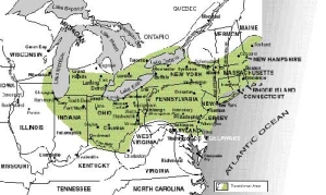
米国製造業の中心地域
ニューイングランド北部を除く北東部は、米国で唯一・最重要の製造業地帯である。この地域は大ざっぱに言うと、オハイオ渓谷、「メガロポリス」、五大湖南岸に囲まれている。しかし、西の境界線はそれほどはっきりしていない。インディアナ州南部やイリノイ州を横断してさらに西へ続く農業地帯と次第に一体化してしまっているからだ。
面積がそれほど広大でなく、他の地域でも製造業が発展してきたにも関わらず、米国の地理における「製造業の中心地域(Manufacturing Core)」の経済的な意味合いは今でも非常に大きい。米国の鉄鋼や自動車・自動車部品の多くは、この地域の工場で生産される。主要な港や通信センター、金融センターの多くはこの地域の内部または近隣地域にあり、米国の政治の首都はそのすぐ隣にある。
この地域には、いくつかの大都市圏が融合して出来上がった米国最大の大都市地帯が2つある。1つは「メガロポリス」であり、もう1つは西側のミルウォーキー(ウィスコンシン州)とシカゴ(イリノイ州)から東側のクリーブランド(オハイオ州)とピッツバーグ(ペンシルベニア州)に至る大都市地域の一群である。
「米国製造業の中心地域」はきわめて対照的な二面性を持っているため、この地域の理解を難しくしている。工業生産で使われる資源やその需要を生み出したのは、多くの点で、この地域に住む農業従事人口の活力と生産性の高さだった。農業がまず成功して初期の市場の発展に貢献し、さらに農業が次第に機械化されたために製造業による様々な支援が必要になったのである。1800年代後半には刈り取り機、穀物を精選する唐箕(とうみ)、耕作機の需要が何万台にも上った。20世紀前半にはトラクター、藁を束ねる農機具、ポンプ、専用農業機械に対する需要が引き続き工業製品需要を支えていた。輸送網が発展し、この地域で収穫した大量の農産物を運ぶことができるようになった。
従って、ここで論じる米国の一地域は異なるテーマを持って互いに依存している2つの地域として取り扱わなければならない。本章では、この地域の製造業の中心部が持つ都会的・工業的性質という1つ目のテーマについて論じる。もう1つのテーマである、小さな町や地方の田舎的・農業的性質については第10章で考えていく。
さて、製造業なるテーマについて、以下のような疑問を考察していく。「一体どのような条件や環境がアメリカ大陸のこの地域にこれほど複雑な経済上の相互依存関係を成立させたのだろうか」「この地域にどのような特徴があったために、重工業やそれに関連する人的活動のすべてがここで発達したのだろうか」--。
米国は工業資源に恵まれている。その広大な内陸平野は、3つの金属鉱物の埋蔵地帯にほぼ囲まれていると言っていい。北方のカナダ楯状地と2つの線状地である。うち1つは北東から南西へ伸びるアパラチア山脈で、もう1つは北西から南東へ伸びるロッキー山脈である。さらに、その内陸平野の地下(特に東側)には、質の高い鉱物燃料が豊富に埋蔵する鉱床がある。従って重工業が必要とする鉱物の量を考えた場合、この比較的狭い三角地帯にそのほとんどが存在することになる。
さらに、「米国製造業の中心地域」の内陸部は資源の輸送経路にも恵まれている。鉱物が豊富なカナダ楯状地と燃料に恵まれた内陸平野を結ぶ五大湖(スペリオル湖、ミシガン湖、ヒューロン湖、エリー湖、オンタリオ湖)は、世界のほかの場所では見られない国内水路を形成している。五大湖は相互につながっており、標高差が大きい場所は2カ所しかない。スペリオル湖とヒューロン湖・ミシガン湖の間にはおよそ6.7メートルというわずかな標高差があるだけで、それも1855年に開通したスーセントマリー運河(ミシガン州)の閘門が解決済みである。エリー湖とオンタリオ湖の間にはさらに激しい標高差がある。これが水上輸送の大きな障害になったかもしれないが、カナダ・オンタリオ州にウェランド運河(1829年開通)が建設されてナイアガラの滝を避けて通航できるようになり、ニューヨーク州にエリー運河(1825年開通)が建設されてオンタリオ湖を通過せずに貨物を運ぶことができるようになった。これらの例外はあるものの、五大湖のおかげで米国の初期の開拓者は800キロメートルを超す安価な輸送手段を利用できたのである。その後19世紀と20世紀初めの頃は、カナダ楯状地の鉄鉱石をイリノイ、インディアナ、オハイオ、ウェストバージニア、ペンシルベニアの各州にある炭田に運ぶにあたり、この安価な輸送手段が不可欠であった。五大湖の南岸で発展した工業生産能力がここに立地した背景には、このように天然の資源輸送経路に恵まれていたこともある。
この内陸部の中心地域を通るオハイオ川は、石炭資源の豊富なアパラチア地域の深遠部から西方へ流れ、数百キロメートルにわたって内陸平野を横断し、最後にミシシッピ川と合流する。数十の支流がオハイオ川に水を供給しており、アクセスのしやすさが向上している。1つにはこれらの支流も航行可能であるという直接的な理由からであり、もう1つは流域が陸上輸送の容易なルートになるという間接的な理由のためである。中心地域の西端に沿って、ミシシッピ川とその支流が南部や西部からの輸送経路となっている。
このように地理的にも鉱物資源の面でも恵まれているという点が非常に珍しいため、「米国製造業の中心地域」はこの内陸部だけだと、しばしば思われがちだ。「中西部工業地帯」や「米国工業の心臓部」と呼ぶことによって想像力をかきたてようとしているのかもしれないが、それでは地理的側面から十分ではない。「米国製造業の中心地域」には内陸部中心地域と「メガロポリス」の両方が含まれており、「メガロポリス」があるからこそ内陸部は国際商取引とつながりを持つことができるのである。
1830年以前には、この地域の都市開発や産業振興は、港の直接の後背地である大西洋沿岸地域にほとんど限定されていた。アパラチア山脈を越えた地域のヨーロッパ人開拓地には、自給自足農業が分散し、都市のような入植地がわずかながら存在するだけだった。1830年から1860年の南北戦争の勃発までの間に、内陸部の人口密度は増加した。農業が盛んになって一定の余剰農産物が定期的に出るようになり、効率的な取引所が必要になった。この地域が発展した根拠は、鉄道網が内陸平野に発達し始めるなど、輸送手段のゆるやかな変化にも現われている。
米国の製造業の地理に直接影響を及ぼした技術の変化を、地理学者のジョン・ボーチャート(John Borchert)は4つの時期に分類している。ボーチャート自身はこれを歴史的な時代と名づけた。
「ジオグラフィック・レビュー」(Geographic Review)誌への寄稿で、ボーチャートは1790年から1830年までの第1期を「帆船と荷馬車の時代(Sail-Wagon Epoch)」と呼んだ。この時期にほとんどすべての都市と町は水上輸送で繋がっていた。沿岸部の川に沿って発達した大西洋岸の港や町が、当時の主要な都市部だった。この時期に主要な内陸水路であるモホーク川、五大湖、オハイオ川に沿って内陸都市部が最も大きな発展を遂げた。
1830年から1870年までの第2期が始まったのは、陸上輸送の形態を大きく変えた技術革新-鉄道の発達-がきっかけだった。この「機関車の時代(Iron Horse Epoch)」は、すでにできあがっていた港湾地域の発展に一層のはずみをつけた。新たな鉄道網が港湾都市に重点的に建設された。その後すぐに「メガロポリス」となった地域で大きな港湾都市がさらに発展したほか、オハイオ川沿いのピッツバーグ(ペンシルベニア州)、シンシナティ(オハイオ州)、ルイスビル(ケンタッキー州)、五大湖南岸のバッファロー(ニューヨーク州)、エリー(ペンシルベニア州)、クリーブランド(オハイオ州)、デトロイト(ミシガン州)、シカゴ(イリノイ州)、ミルウォーキー(ウィスコンシン州)、ミシシッピ川沿いのセントルイス(ミズーリ州)、メンフィス(テネシー州)、ニューオリンズ(ルイジアナ州)などの都市が最も発展した。
1870年から1920年までの「鉄鋼レールの時代(Steel-Rail Epoch)」をもたらした要因はいくつかある。それは鋼鉄の発達であり、鉄のレールに替わって強度と重量で勝る鉄鋼のレールの登場であり、瀝青炭(軟炭)の需要増や発電の普及も挙げられる。都市部が最も大きく発展したのは「米国製造業の中心地域」の周辺にある都市だけだったが、注目すべき例外もいくつかあった。炭田や五大湖の近く、または大都市間を結ぶ主要鉄道路線沿いにも多数の小都市が発達したことである。これらの都市がそれなりの地歩を固めることができたのは、その間を結ぶ鉄道網がオハイオ川と五大湖の間の地域に緊密に敷かれていたためである。石炭と鉄鋼の町であるピッツバーグと、鉄鉱石を出荷する港と鉄鋼の町であるクリーブランドの間に位置するオハイオ州のアクロン、キャントン、ヤングスタウンは、この時期に発達した小都市のまさに典型である。
1920年から1960年までの第4期が「車と空の快適さの時代(Auto-Air-Amenity Epoch)」だった。自動車や航空機といった輸送手段の技術革新は、人間の移動性を高め、製造プロセスにおける出荷コストの影響を最小限に抑えるという点で影響が大きかった。産業は人口が最も増加した地域に集中したが、これらは主に伝統的な製造業の中心地域以外にある快適な環境の地域(カリフォルニア州、フロリダ州、アリゾナ州)だった。
1960年以降、米国はさらに新しい時代に突入した。この時代を「情報技術の時代(Information Technology Epoch)」と呼んでもいいだろう。米国経済が情報の創出と交換に依存するようになるにつれ、今後は情報の加工・伝達手段の発達によって、安価な大量輸送手段や大きな人口集積さえも必要としない産業の発展が促されることになるだろう。このことから、20世紀の最初の70年間近く「製造業の中心地域」にある都市の発展を支えた諸要素であったとしても、今後の数十年間はもはや発展上、特別有利には働かないことがわかる。ただし、これらの都市が持つ熟練労働者、大きな市場、確立した航空輸送網が都市の成長に寄与するケースは出てくるだろう。
ボストン、ニューヨーク、フィラデルフィア、ボルティモアといった港湾都市やその衛星都市は、早い段階からしっかりと商業や商業に触発されて発展した金融取引を経済基盤としており、製造業が米国経済の主流になるずっと以前から人口を増やし始めていた。ほかには類をみないほど大きな地域市場、豊富な労働力、水上輸送への容易なアクセスが望めるとの期待のもとに、製造業は東部沿岸地域に引き寄せられたが、ほとんどの「メガロポリス」都市の経済はそれぞれ独特の業種上の特徴を持っていた。
ニューイングランド地方は、港の発展と同時に製造業が発達したという点で例外だった。造船業が沿岸地域に繁栄し、造船という複雑な事業の下請となる子会社のメーカーを無数に生み出した。工業の重要性が米国のほかの地域で高まり始めたとき、ニューイングランドには製造業にとって有利な条件がいくつかあった。そのうち最も重要だったのは、この地域には小さいけれども河川が多数存在しており、簡単に電力を供給できたことである。
ニューイングランドの中心地であるボストンは、アメリカ大陸の中心部にあるこの地域の多くの変貌ぶりを物語っている。ボストンのアパレル・皮革産業や、近隣のコネチカット州の造船業は昔の名残だが、過去50年くらいの間で最も発展したのは電子部品や機械製造業だった。港湾やその設備は今でも優れているが、ニューイングランドの産業は今では製品のほとんどを陸路で米国のその他の地域の市場に運ぶか、メガロポリスの主要港である南のニューヨークまで送ってそこから輸出している。
米国の港湾の中でもニューヨークが特に優れていることについてはすでに説明した。予想できることだが、製造業はこの国際商取引の中心地に近接することと、その周りに人口が集中していることが製造業にとって非常に有利であると考えた。この点の魅力が強烈だったため、ニューヨークの産業構成は極めて多様になった。20世紀の初頭以降まで、多くの産業がマンハッタンに拠点を構えた。空間集約的なオフィス・ビジネスが発展して空間に対する需要が高まるにつれ、重工業はマンハッタン南端やマンハッタンの境界線を越えてハドソン川の向こうにあるニュージャージー州干満のある湿地へと次第に押しやられていった。
ニューヨークの大都市経済はここしばらくオフィス産業が幅を利かせている。これらは対応を迅速に伝達する世界規模の情報ネットワークや設備を必要とする、多数の民間企業、銀行や保険会社、出版社、その他多くのサービスおよびコントロール・センターの活動の中心である。
フィラデルフィアとボルティモアの2つの都市は、受け継いだ産業的特質や都市としての特徴がまったく異なっていたが今後はもっと似てくるかもしれない、という徴候を近年顕著に示している。フィラデルフィアの製造業基盤は、食品加工業や造船・船舶修復業をより重視しているもののニューヨークと同じくらい多様化している。
フィラデルフィアの産業基盤は、北にわずか120キロメートルの位置にあるニューヨークの方が、港としても内陸への輸送経路としても優れているということからある程度発展が妨げられていた。しかし、ペンシルベニア州西部の石炭・鉄鋼地域へのアクセスという点ではフィラデルフィアの方が優れており、その港湾施設も立派で、 また米国の初期の政治・文化の中心としての遺産もあったため、フィラデルフィアは「メガロポリス」の大都市圏として成長を続けることができた。一方、ボルティモアは常に「製造業の中心地域」の周辺部に位置してきた。フィラデルフィアと同様、その港は内陸部の石炭・鉄鋼地域と鉄道で結ばれているため、ボルティモアの産業構成はこの点を反映したものになっている。輸送機械の製造もボルティモアの重要産業である。
この他、フィラデルフィアとボルティモアでは金属製造と化学という2つの産業が盛んだが、このことから沿岸部にあるこの地域が内陸部重工業地帯とつながっていることがわかる。
「米国製造業の中心地域」のもう1つのさらに大きな部分である中西部産業地帯の主な都市については、内陸部の豊かな鉱物・農業資源に対するその位置関係が最も大きな特徴である。製造業地域の西部にあるほぼすべての大都市は、オハイオ川またはその支流の1つ、もしくは五大湖の沿岸に位置している。
「製造業の中心地域」の内陸部における都市部の発展で最も重要な役割を担ったのは、カナダ楯状地の端からペンシルベニア州西部やウェストバージニア州の炭田への金属鉱石の輸送と、これより量は少ないが、その逆方向への石炭の輸送だった。鉄鉱石はミネソタ州北部のメサビ山地とミシガン州北部とウィスコンシン州のゴギービック、マルケット、メノミニー山地で採掘される。メサビ鉱石は現在鉱床で粒状に加工されるが、過去には何十年もの間五大湖を航行できるように特注した大型船で、未加工の鉱石をミシガン湖やエリー湖の南岸まで運んでいた。鉱石と鉱石粒はミシガン湖の南岸にあるインディアナ州ハモンドとゲーリーまで運ばれる。そこにはイリノイ州にある広大な炭田から鉄道で北に輸送された石炭も運ばれてくる。しかし、鉄鉱石のほとんどはエリー湖畔の港へ出荷される。そこから南のオハイオ川流域にある鉄鋼の町に主に運ばれるか、エリー湖岸にある都市でアパラチア炭田からの復路を鉄道で北へ運ばれる石炭を使って鉄鋼に加工される。
内陸部の中心にある都市のうち、ピッツバーグはその名前が鉄鋼と同義語になった。アレゲーニー川とモノンガヒーラ川が合流してオハイオ川になる場所にあるピッツバーグは、原材料と下流の市場の両方にアクセスを持つ利点を利用できる有利な位置にある。アレゲーニー川とモノンガヒーラ川は石炭が豊富なアパラチア山脈のはずれの地域に注ぎ込み、オハイオ川は「農業の中心地域」の南端に沿ってミシシッピ川に流れ込む。ピッツバーグの発展とともに安価な水上輸送手段が手近にあるという点を利用しようと、鉄鋼に依存する産業がこの狭い川沿いの低地に集まってきた。金属製造業、機械部品、その他の大量に鉄鋼を消費する産業が工場をピッツバーグやその周りに建設した。近隣都市もピッツバーグの鉄鋼が持つ強力な牽引力の恩恵に浴した。オハイオ州のヤングスタウン、キャントン、スチューベンビル、ウェストバージニア州のホイーリングとウィアトン、さらにペンシルベニア州のニューカッスルとジョンズタウンは、この地域の産業の発展をある程度共有し鉄鋼および鉄鋼製品産業を作り上げた。
都市化・工業化が進展したのは、石炭生産地域だけではなかった。五大湖の輸送体系を利用して運ばれる鉄鉱石は、最終的にはピッツバーグ地域まで運ぶためエリー湖岸のどこかの地点で鉄道に積み替えなければならなかった。
クリーブランドはエリー湖畔の最大の港町だった。クリーブランドが最初に発展したきっかけは、細くて曲がりくねったカイヤホガ川とオハイオ川の支流とを結ぶ運河の建設だった。運河建設の効果はわずかしか続かず、すぐにクリーブランドの成長においつかなくなってしまったが、近くのほかの都市より一歩先んじたスタートをするには十分だった。その結果生まれた多様な産業基盤は、湖が提供してくるアクセスのよさ、ニューヨークとシカゴ、そして「農業の中心地域」や西部をつなぐ東西の主要鉄道路線によるアクセスのよさを利用できた。クリーブランドの発展は、オハイオ州のロレーン、アシュタビュラ、コノートなどの港町や、東はペンシルベニア州のエリー、さらにずっと西に進んだオハイオ州のトレド、そしてゴム工業都市であるオハイオ州アクロンのような内陸部の補完的成長中心地まで及んでいった。
ニューヨーク州バッファローはエリー湖の東端に位置している。グレートプレーンズがまたがる諸州で収穫した小麦は五大湖の西側に運ばれ、そこからまとめてバッファローに運ばれ精製される。湖岸沿いのほかの地域で鉄鋼と金属製造業を生み出した同じ要因によって、バッファローでも製造業の大部分が鉄鋼と金属の関連産業になった。近くのナイアガラの滝を水力発電に利用できるようになったため、化学・アルミニウム産業を引っ張ってくるようになった。
ヒューロン湖とエリー湖の間の狭い水路上にある都市、デトロイトがまがりなりにも発展したのはやっと20世紀の初頭になってからだが、それはデトロイトがニューヨークとシカゴ間を結ぶ主要鉄道路線から80キロメートル以上も北に位置しているからである。デトロイトがその最も知られた特徴を持つようになったのは、陸上輸送で鉄道の重要な競争相手である自動車を育てる産業が生まれてからだった。最も成功した自動車メーカーはデトロイトとその周辺の都市に集中し、自動車の需要が急増して様々な部品メーカーをミシガン州南東部に引き寄せてきた。
五大湖の南端にあるその他の2つの大都市圏のうち小さい方がミルウォーキーである。ミルウォーキーは産業として重工業と自動車産業を持っているが、そのほかに、多数のドイツ系移民が19世紀後半にウィスコンシン州に定住した結果、醸造産業の一大中心地となった。ミルウォーキーはウィスコンシン州の「酪農地帯」(Dairy Belt) の中心に位置しているため、食品加工産業も盛んである。
シカゴが内陸部の「製造業の中心地域」で最も重要な都市であることは疑うべくもない。その重要性が非常に高まったため、シカゴの人口がニューヨーク市に次ぐ全米第2位(1990年に2,725,979人)であることを称えて、長年「全米第2位の都市(Second City)」と呼ばれていた。今ではロサンゼルスの人口がシカゴを上回ったが、この中西部の非公式な「首都」は米国内陸部で最も都市化が進んだ中心都市として君臨している。
ミシガン湖の南西岸に位置するシカゴは、湖と豊かな農業地域の間、そして西部や南西部へヒトやモノを移動するのに絶好の位置にある。シカゴの中心を一部流れるイリノイ・ミシガン運河は、五大湖とミシシッピ水系を結んで1848年に完成した。4年後、シカゴは鉄道でニューヨークとつながり中西部最大の鉄道拠点になった。
シカゴには19世紀半ばから後半にかけて数千人の移民を受け入れ、イリノイ州、ウィスコンシン州、その向こうの農業州まで放射線状の鉄道網が敷かれた。シカゴの大きな家畜飼育場の周辺には、食肉加工卸売業が発展した。家具や衣料メーカーなどのその他の産業は、成長する地域市場を利用するため、また西部の市場への優れたアクセスを生かすために、シカゴに拠点を置いた。20世紀に入ると、鉄鋼産業がシカゴ地域に進出した。実際にはシカゴ市内ではなくその南側だが、イリノイ州とインディアナ州の湖岸沿いにあり、シカゴの比類のない鉄道網を容易に利用することができた。
1890年にはすでに人口100万人を擁する都市であったシカゴは、1910年までに規模が2倍になり、1920年代半ばには人口300万人を超えた。今日、シカゴの製造活動の規模に匹敵しうるものは、ここで生産される製品のとてつもない多様性ぐらいのもので、少なくとも部分的には「メガロポリス」にある経済の中心地に対する地域の均衡勢力としての役割を果たしている。
*上記の日本語文書は参考のための仮翻訳で、正文は英文です。
The Manufacturing Core
(The following article is taken from the U.S. Department of State publication, An Outline of American Geography.)
The Manufacturing Core
By Stephen S. Birdsall and John Florin
Manufacturing is an important economic activity in the United States. The evidence of this is everywhere – in articles of clothing, items of preserved food, residential structures, means of transport and communication, and many other things. In spite of the presence of items manufactured outside the country, domestic industry remains paramount, and it is rare for any medium-sized U.S. town to be without at least some local employment in manufacturing.
The northeastern United States, excluding northern New England, is the country's single most significant region of manufacturing. This region is loosely defined on three sides by the Ohio River Valley, Megalopolis, and the southern Great Lakes. The western margin of the region is less clear; it blends gradually with agriculture-dominant landscapes across southern Indiana, Illinois, and beyond.
In spite of the region's moderate extent and the growth of manufacturing elsewhere, the Manufacturing Core continues to be of tremendous economic significance in American geography. Its factories produce most of the country's steel, as well as a significant percentage of its motor vehicles and motor vehicle parts. Most of the important ports, the main centers of communication, and the primary financial centers are within or near the region, and the country's political capital is on the immediate margins.
The region includes the two largest clusters of coalescing metropolitan areas: Megalopolis, and the group of large urban regions between Milwaukee ( Wisconsin) and Chicago (Illinois) on the west, and Cleveland (Ohio) and Pittsburgh (Pennsylvania) on the east.
Understanding America's Manufacturing Core is made difficult by its strongly dual character. In many respects, it was the vitality and productivity of the territory's farm population that created the resources and the demand for industrial production. Success in agriculture supported the region's early market centers, and it was the gradual mechanization of agriculture that demanded diversified manufacturing support. Mechanical reapers, winnowing machines, and cultivating implements by the tens of thousands were required during the later 1800s. Tractors, hay balers, pumps, and increasingly specialized farm machinery continued to be important local sources of industrial demand during the first half of the 20th century. Transportation lines were improved and expanded to carry the tremendous volume of agricultural products grown on the region's farms.
Therefore, we encounter here a single portion of America that must be treated as two interdependent thematic regions. One theme, the urban and industrial nature of the region's manufacturing centers, is discussed here. The other, the rural and agricultural character of the territory's small towns and countryside, is presented in chapter 10.
Turning to the manufacturing theme, what set of conditions or circumstances led to the development of so complex a mix of economic interrelationships on this portion of the continent? What is it about this region that encouraged the growth of heavy manufacturing industries and all of the related human activities that have come to dominate here?
MINERAL RESOURCES
The United States is blessed with industrial resources. America's broad interior plains are nearly enclosed by zones of metallic mineral concentrations: the Canadian Shield to the north and two linear areas, one extending northeast-southwest (the Appalachian Mountains) and one extending northwest-southeast (the Rocky Mountains). Furthermore, much of these same interior plains are underlain by large deposits of high-quality mineral fuel, especially in the eastern section. In terms of the mineral requirements of heavy industry, then, a relatively small triangular region contains much of what is needed.
Also, the interior portion of America's Manufacturing Core possesses great accessibility resources. Connecting the mineral-rich Canadian Shield and the fuel-rich interior plains, the five Great Lakes – Superior, Michigan, Huron, Erie, and Ontario – represent an internal waterway unlike any other in the world. The Great Lakes are interconnected with only two significant changes of elevation. A small drop of about 6.7 meters between Lake Superior and Lakes Huron and Michigan was overcome by locks at Sault Sainte Marie, Michigan, first opened in 1855. The much greater change of elevation between Lakes Erie and Ontario might have been a serious barrier to water transport, but the Welland Canal (first opened in 1829) was built in Ontario to skirt Niagara Falls, and the Erie Canal was constructed (by 1825) in New York to permit some freight to avoid Lake Ontario altogether. With these exceptions, the lakes offered well over 800 kilometers of inexpensive transportation to early developers of America. Later, in the 19th and early 20th centuries, the same cheap transportation was of critical importance to those moving the Shield's iron ore to the coal fields in Illinois, Indiana, Ohio, West Virginia, and Pennsylvania. Much of the basis for the location of the industrial capacity that developed along the southern margins of the Great Lakes can be attributed to this natural accessibility resource.
Within the interior core, flowing westward from deep within the coal-rich Appalachian region, the Ohio River crosses the interior plains for hundreds of kilometers before joining the Mississippi River. Dozens of tributaries supply the Ohio with its water and provide further accessibility, either directly because they are navigable, too, or less directly because they offer easier routes of land movement through their valleys. Along the western margin of the core region, the Mississippi River and its tributaries provide access from the south and west.
So unique is this combination of spatial and mineral resources that the Manufacturing Core in the United States is often thought of as this interior territory alone. References to "the industrial Midwest" or "America's industrial heartland" may seek to fire the imagination, but they are geographically incomplete. The American Manufacturing Core includes both the interior core and Megalopolis, the urban region through which the interior has its primary linkage to international commerce.
Prior to 1830, the region's urban and industrial development was limited almost entirely to the Atlantic Coast in the ports' immediate hinterlands. European settlement of the trans-Appalachian area consisted of scattered subsistence agriculture and a few urban outposts. Between 1830 and the outbreak of the U.S. Civil War in 1860, population density in the interior increased and agriculture intensified and began to produce a regular surplus, spurring demand for efficient centers of exchange. The foundations for the growth of the region are reflected in the gradual shift of transportation concentration as railroad lines began to be spread across the interior plains.
The technological changes that directly affected the manufacturing geography of the United States have been grouped by one geographer, John Borchert, into four periods, or historical epochs as he called them.
Writing in Geographic Review, Borchert identified the earliest period, 1790-1830, as the Sail-Wagon Epoch. During this period, almost all cities and towns were associated with water transportation. The Atlantic ports and towns that had their beginnings along some of the coastal rivers were the major urban centers. The greatest inland urban growth during this period occurred along the main inland waterways – the Mohawk River, the Great Lakes, and the Ohio River.
The second period, 1830-1870, was triggered by development of the railway, a radical innovation in land movement. The Iron Horse Epoch at first stimulated further growth in the already established port locations. The new railway networks were constructed to focus on the port cities. Aside from additional growth of the larger port cities in what was soon to become Megalopolis, the greatest growth occurred in such cities as Pittsburgh (Pennsylvania), Cincinnati (Ohio), and Louisville (Kentucky) (all on the Ohio River); Buffalo (New York), Erie (Pennsylvania), Cleveland (Ohio), Detroit (Michigan), Chicago (Illinois), and Milwaukee (Wisconsin) (all on the lower Great Lakes); and St. Louis (Missouri), Memphis (Tennessee), and New Orleans (Louisiana) (all on the Mississippi River).
The Steel-Rail Epoch, 1870-1920, was stimulated by the development of steel, the replacement of iron rails with stronger and heavier steel rails, increased demand for bituminous coal, and the spread of electric power generation. Although the greatest growth in national urban areas occurred in cities only peripheral to the Manufacturing Core, there were several notable exceptions -- the numerous smaller cities near the coal fields, near the Great Lakes, or on one of the major rail connections between larger cities. These cities were able to establish themselves because the interconnecting rail network crisscrossed the region so densely between the Ohio River and the Great Lakes. Akron, Canton, and Youngstown, Ohio, are clear examples, because they are located between the coal-and-steel city of Pittsburgh and the iron-ore port and steel city of Cleveland.
A fourth epoch, the period 1920-1960, was the Auto-Air-Amenity Epoch. The main effects of transport innovations such as the automobile and the airplane were to increase individual mobility and to minimize the impact of shipment costs in the production process. Industry was drawn to areas of greatest population growth; these were primarily the amenity areas (California, Florida, Arizona) outside the traditional manufacturing core.
The United States entered yet another period after 1960, one that might be called the Information Technology Epoch. As the U.S. economy becomes more dependent on the production and exchange of information, the means of processing and transmitting this information will encourage the growth of industries that do not need cheap bulk transportation or even large population clusters. This suggests that those factors that supported growth in the Manufacturing Core cities during the first two-thirds of the 20th century will no longer provide those cities with special development advantages during future decades, although their skilled labor forces, large markets, and established air transportation patterns will make some of them strong competitors for growth.
CITIES IN THE REGION
With Boston, New York, Philadelphia, and Baltimore based early and firmly on commerce and the financial exchanges it stimulated, these ports and their satellites began to accumulate population long before manufacturing became dominant in the U.S. economy. Although manufacturing was drawn to the eastern coast by the promise of matchless local markets, tremendous labor supplies, and easy access to water transportation, the economies of most of Megalopolis's cities maintained a distinctly professional character.
New England was the exception by developing manufacturing at the same time that its ports were growing. Shipbuilding industries thrived along the coast and generated countless subsidiary manufacturing operations needed to supply such a complex industrial undertaking. When factory industry began to grow in importance elsewhere in America, New England had several advantages that kept manufacturing significant, the most important of which was the ready availability of power in the area's small but abundant rivers.
Boston, as the regional capital of New England, characterizes many of the changes in this portion of the continental core. Boston's apparel and leather industries, as well as shipbuilding in nearby Connecticut, are remnants of an earlier period, but most growth in the last 50 or so years has occurred in electronic components and machinery. The harbor and the facilities found there remain excellent, but industry in New England now ships most of its products by land, either to markets in the rest of the United States or south to New York for export through Megalopolis's primary port.
New York's primacy among American harbors has been discussed. As might be expected, manufacturing industries found proximity to this node of international commerce and the population cluster around it to be very advantageous. So strong was this pull that New York's industrial mix became extremely diversified. Many industries were located on Manhattan until after the beginning of the 20th century. The increasing demand for space by the even more space-intensive office businesses gradually pushed the heavier industry to the very margins of lower Manhattan or beyond the island's confines into the New Jersey tidal marshes across the Hudson River.
The New York metropolitan economy has been dominated for some time by office industries. These are the headquarters for activities of dozens of companies and corporations, the banking and insurance cluster, publishing houses, and all the other service and control centers that require a worldwide information network and the facilities to transmit their responses rapidly.
Philadelphia and Baltimore, so different in industrial inheritance and urban character, have shown indications during recent years that they may be becoming more alike. Philadelphia's manufacturing base is almost as diversified as New York's, although there is a greater emphasis on food-processing industries and on shipbuilding and ship repair.
The growth of Philadelphia's industrial base suffered somewhat from the presence of New York's better harbor and superior access to the interior only 120 kilometers to the north. But Philadelphia's better access to the coal and steel regions of western Pennsylvania, its respectable port facilities, and its heritage as an early political and cultural center in the United States have maintained the Philadelphia metropolitan region's growth within Megalopolis. Baltimore, on the other hand, has always been on the periphery of the Manufacturing Core region. Like Philadelphia, its port possessed good rail connections with the coal and steel regions of the interior, and Baltimore's industrial mix reflects this. The manufacture of transport machinery is also important in Baltimore.
Two additional industrial sectors – metals fabrication and chemicals – are well represented in Philadelphia and Baltimore, and they emphasize the coastal connections of these regions with the heavy industrial interior.
The major cities of the other, larger portion of America's Manufacturing Core region, the industrial Midwest, have derived their primary character from their location relative to the rich mineral and agricultural resources of the continent's interior. Almost all of the large cities in the western portion of the manufacturing region are located along the Ohio River or one of its tributaries, or along the shores of one of the Great Lakes.
Most important in the development of urban centers in the interior portion of the Manufacturing Core has been the movement of metallic mineral ores from the margins of the Canadian Shield to the coal fields of western Pennsylvania and West Virginia, and the smaller movement of coal in the reverse direction. Iron ore is mined at the Mesabi range of northern Minnesota and at the Gogebic, Marquette, and Menominee ranges in northern Michigan and Wisconsin. Mesabi ore is now processed into pellets at the deposit site, but for decades unprocessed ore was carried to the southern shores of Lakes Michigan and Erie in large ships designed specially for Great Lakes travel. Pellets and ore are carried to the southern shore of Lake Michigan, to Hammond and Gary in Indiana, where these shipments are met by coal transported north by rail from the large Illinois coal fields. Most of the ore, however, is shipped to Lake Erie ports. From there, it is either carried south, primarily to the steel cities of the Ohio River, or converted to steel in the lakeside cities using coal carried north on the return rail trip from the Appalachian fields.
Of the cities of the interior core, Pittsburgh is the one whose name became synonymous with steel. Located where the Allegheny and Monongahela Rivers join to form the Ohio River, Pittsburgh was in an excellent position to take advantage of access to both raw materials and downriver markets. The Allegheny and the Monongahela drain the coal-rich margins of the Appalachians, and the Ohio flows along the southern margins of the Agricultural Core and into the Mississippi. As Pittsburgh grew, industries that depend on steel crowded onto the narrow river bottoms to take advantage of proximity to low-cost water transportation. Metal-fabricating industries, machine parts, and other industrial consumers of large quantities of steel located their plants in and around Pittsburgh. Nearby cities also benefited from the powerful pull of steel at Pittsburgh. Youngstown, Canton, and Steubenville in Ohio, Wheeling and Weirton in West Virginia, and New Castle and Johnstown in Pennsylvania shared to some degree in the industrial growth of this region and obtained steel and steel products industries.
Urban-industrial growth did not occur solely at the source region of coal. The iron ore shipped across the lake system had to be transferred to railroads at points along the Lake Erie shore for final movement to the Pittsburgh region.
Cleveland was the largest of the Lake Erie port cities. Cleveland's initial growth was stimulated by a canal connecting the narrow and winding Cuyahoga River with a tributary of the Ohio River. Although the city quickly outgrew this small initial advantage, it was enough to give Cleveland a head start on its nearby urban competitors. The diverse industrial base that resulted took advantage of the accessibility offered by the lakes and by the major east-west railroads connecting New York with Chicago and the Agricultural Core to the west. Cleveland's growth also spilled over into adjacent ports, such as Lorain, Ashtabula, and Conneaut, Ohio, and perhaps as far east as Erie, Pennsylvania, and as far west as Toledo, Ohio, as well as to complementary growth centers inland, such as the rubber-producing city of Akron, Ohio.
Buffalo, New York, is located at the eastern end of Lake Erie. Wheat from the Plains states is brought to the western Great Lakes and carried in bulk to Buffalo for refining. The same factors that generated steel and metals manufacturing elsewhere along the lakeshore helped ensure that a significant portion of the city's manufacturing would be connected to this type of industry. The harnessing of nearby Niagara Falls for hydroelectric power attracted chemical and aluminum industries.
The city on the narrow water passage between Lakes Huron and Erie, Detroit, grew rapidly only early in the 20th century because it is located more than 80 kilometers north of the primary New York-Chicago rail connection. It was not until the rise of the industry that fostered the railroads' chief land transport competitor – motor vehicles – that Detroit developed the character for which it is best known. The most successful automobile manufacturers concentrated in Detroit and nearby cities, and the demand for automobiles skyrocketed, drawing a variety of component suppliers to southeastern Michigan.
The smaller of the two remaining metropolitan centers along the southern Great Lakes margin is Milwaukee. In addition to its industrial mix of heavy industry and motor vehicle manufacturing, Milwaukee is one of the leading centers of the brewing industry, a result of the large number of German immigrants who settled in Wisconsin during the late 19th century. A significant food processing industry is also present in Milwaukee, because it is a major focus for the middle Dairy Belt of the state.
Chicago is easily the dominant city of the interior Manufacturing Core. So important did this city become that, for many years it was called the "Second City," recognizing Chicago's population (2,725,979 in 1990) as second only to that of New York City. Although Los Angeles now outranks Chicago in population, the informal "capital" of the Midwest persists as the strongest urban focus of the United States' interior.
Located along the southwestern shore of Lake Michigan, Chicago occupies the optimum location for the transfer of people and goods between lake transportation and the rich agricultural region to the west and southwest. The Illinois and Michigan Canal, located in part through the heart of the city, was completed in 1848 to link the Great Lakes and the Mississippi River system. Four years later, Chicago was connected to New York by rail and became the primary regional rail focus in the Midwest.
Chicago absorbed thousands of immigrants throughout the later 19th century and spawned a radial network of rail lines into Illinois, Wisconsin, and the agricultural states beyond. Meatpacking developed around the city's large stockyards. Other industries, such as furniture and clothing manufacturers, located there to take advantage of the growing local market and good access to markets farther west. After the turn of the century, the steel industry was introduced to the Chicago region, south of the city itself but still along the lakeshore in Illinois and Indiana and easily accessible to the city's unparalleled railroad network.
Already a city of 1 million by 1890, Chicago doubled in size before 1910 and exceeded 3 million by the mid-1920s. The volume of Chicago's manufacturing activities today is matched only by the immense diversity of products manufactured, making the city at least partly an effective regional counterbalance to the intense economic nodes in Megalopolis.
[Stephen S. Birdsall is dean of the College of Arts and Sciences at the University of North Carolina at Chapel Hill. He holds a master's and a doctoral degree in geography from Michigan State University and is the co-author of four books and atlases, including Regional Landscapes of the United States and Canada.]
[John Florin is chair of the geography department at the University of North Carolina at Chapel Hill. He holds a master's and a doctoral degree in geography from Pennsylvania State University. His recent publications include Atlas of American Agriculture: The American Cornucopia with Richard Pillsbury and Regional Landscapes of the United States and Canada with Stephen S. Birdsall.]