
国務省出版物
米国の地理の概要 – 自然環境
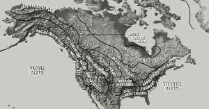 米国では地形学的特徴が一致する地域が南北に広がっているのが一般的である。国の内陸部はメキシコ湾からカナダ国境、さらにアラスカまで広大な低地が延々と続いている。地形の発達形成に関心を持つ地理学者はこの広い低地となだらかな丘陵地帯を「大西洋およびメキシコ湾の沿岸平野」、「内陸低地」(ここをグレートプレーンズと内陸平野に分ける人もいる)、そして「カナダ楯状地」(Canadian Shields)という3つの異なる自然地理学的な地域に分けている。
大西洋およびメキシコ湾の沿岸平野は米国の東海岸に沿って北に伸び、ニューイングランドの南端に達している。この地域の地下には、最近の地質年代に浅い海が何度も陸に打ち寄せて堆積したもろくて簡単に浸食される若い岩石層が幾重にも重なっている。この低い平野は海底まで延びて大陸棚を形成しており、場所によっては海岸から400キロメートル以上先まで広がっている。
その北に位置する内陸低地は沿岸平野より起伏が目立つが、険しい地形はほとんどない。この地域はコーヒーカップの受け皿のように縁(へり)が高くなっており、何層もの堆積岩で覆われている。この堆積層は概して非常に平坦である。地形学的な変化はそのほとんどが局地的な浸食によるものである。もしくは北部のように氷河時代に氷河性堆積物によって発生したものである。
グレートプレーンズの地質学的構造は内陸平野とほとんど変わりない。堆積層が圧倒的な広がりを占めているが、北部では浸食作用によって形成されたドーム状の岩山が堆積層を分断している。その最も有名な例がサウスダコタ州西部のブラックヒルズである。堆積層は水平に近いものの実際はロッキー山脈のふもとの谷間に向かって西へなだらかに傾斜している。その谷間にデンバーやコロラドスプリングズなどのコロラド州の都市がある。
グレートプレーンズと内陸平野の境界では一連の低い断層が目立つ。この断層崖はロッキー山脈の浸食によって形成され、グレートプレーンズを覆っているもろい堆積物のマントルの東端に当たる。
この広大な内陸の低地地域が持つ特性は、米国の経済史および開拓史に多大な影響を及ぼしてきた。農地として大きな潜在的能力を秘めていることに加え、国土のほぼ半分は移動の重大な障害となる地形に出会わずに横断できる。そのお陰でこの地域とさらに遠く離れた西部の双方を米国の経済構造に統合することが容易になった。内陸低地のほとんどはミシシッピ川もしくはその支流の流域にある。この河川域構造がアパラチア山脈の西側の地域に輸送と経済の中心地を提供し、地域の統合を助けたのである。
中央部の低地帯の北側から北東には、古くて固い結晶質岩石が地表部に横たわる「カナダ楯状地」がある。ずっと南に下って低地帯では、かつて国土の中央部まで海が広がっていたころの海底に堆積した堆積層が結晶質岩石を覆っている。また浸食によって楯状地の表面が削られ、局所的にわずかな起伏を持つ低地ができている。
「カナダ楯状地」は過去100万年の間に、巨大な大陸氷河によってその地形が作り変えられている。その程度は北米にある他のどの自然地理学的地域をもしのぐ。この氷河は、ロッキー山脈(Rocky Mountains)とコースト山脈(Coast Ranges)の東に位置するカナダのほぼ全域を覆い、南側は現在のミズーリ川とオハイオ川の流域近くまで及んでいた。
氷河は重量が何トンにも及ぶ岩を地表から剥がして遠くまで運び去ることができた。巨岩は氷河によって運ばれ、落とされた位置にそのままとどまり、楯状地の景観の至るところに散らばっている。氷河の端から溶け出した氷が大きな河を生み海に向かう広大で新しい経路を作り出した。
氷河作用によってカナダ楯状地の表面は大きく削り取られた。今日ではこの地域の覆土は非常に薄いか、もしくはまったく存在しない。河川の水系は酷く分断されている。多くの川が堆積物でせき止められたり、海ではなくこの地域の迷路のような湖や湿地に流れ込んだりしている。例えば、「1万の湖を持つ土地」と呼ばれるミネソタ州中部および北部は、ミネソタ、ミシガン、ウィスコンシンの各州まで広がる氷食楯状地の南側の周辺部に位置する。
南に下ると氷はそれほど厚くなくしたがって力も弱かったため高地が氷河の流れを変えたり分岐させたりした。例えばニューヨーク州中部では、モホーク川の南にある高地が氷河をせき止めた。しかし細い氷河の流れがモホーク川支流の谷間を浸食し、次第に広く深くしていった。今日、ニューヨーク州の「フィンガー・レークス」と呼ばれる深くて細長い湖群はこうした氷食によって拡大された谷間にできたものであり、米国有数の景勝地になっている。
氷河の南端とそこからさらに南の一帯では、浸食作用ではなく堆積作用が見られる。これは氷河作用が残した最大の痕跡である。内陸低地の広い地域は、漂礫土(氷河が運んだ岩や土壌)のマントルで覆われている。その厚さは1メートル未満の場所から100メートル以上に至るまで様々である。氷河が長い間静止していた場所にはモレーン(moraine=氷堆石)と呼ばれる小高い丘ができた。東部では、スタテンアイランド、ロングアイランド、マーサズビニャード、ナンタケット、ケープコッドなどが、南東に向かって広がった氷河の最遠端に当たるモレーン(氷堆石)群である。五大湖の南の地形は長くて低い半円形のモレーン(氷堆石)の尾根と、その他の氷河堆積物で構成されている。
内陸低地の一角には氷河作用を免れた場所がある。ウィスコンシン州の南西部4分の1と隣接するミシシッピ川流域の400キロメートルにわたる渓谷は、北側にあるスペリオル高地が氷の流れを防ぐ障壁の役目を果たしたこと、さらにミシガン湖とスペリオル湖の深い渓谷に氷の流れがそれたことによって氷河作用を受けなかったらしい。その結果「ドリフトレス・エリア」(ドリフトは漂礫土の別名)と呼ばれる天然橋や天然アーチなど、もろい岩石でできた組成物を持つより鋭角的な地形ができあがった。
氷河が後退するのに伴い氷河の縁に沿っていくつか大きな湖ができた。グレートプレーンズの北部にはアガシー湖とレジーナ湖という2つの巨大な湖ができ、その総面積は今日の五大湖よりも広くなった。そしてさらに氷河が後退するにつれて、2つの湖はほとんど姿を消した。現在この2つの湖の存在の跡を示すものは湖底だけであり、ノースダコタ州とミネソタ州の一部にかかる平坦な地域がそれに当たる。
氷河作用が広い範囲で進行していた頃は海面の水位は著しく低かった。従って海に流れ込む多くの川は高低差が大きくなり、川による浸食作用が促されることになった。さらにこれらの川の渓谷は、その多くが現在は海である場所にまで延びていた。ほかの多くの川と同様、サスケハナ川とハドソン川の渓谷はこの時期に深さが増した。氷河が後退して海面が上昇すると、これらの深い谷に海水が流れ込んだ。このようにして世界有数の2つの港湾地域ができあがった。その1つは水深が深いハドソン川の河口に位置し、スタテンアイランドとロングアイランドによって形成される防護壁を備えたニューヨーク湾である。もう1つは、サスケハナ川やかつてはその支流だったポトマック川やジェームズ川などの「溺れ谷」(drowned valley)であるチェサピーク湾である。
東部の沿岸平野は北上するにつれて張り出してくるアパラチア高地の影響で海岸に向かって次第に狭まり、最終的にはケープコッドで低地が完全に消滅してしまう。そこからさらに北東の沿岸部の地形はアパラチア山系の北側の張り出しの一部となる。現在のアパラチア山脈はかつて存在していた高い山脈が浸食された結果残ったものであり、米国東部の大半にわたり沿岸地帯と内陸低地を隔てている。
この地域ではほとんどの場所で土壌が浅いうえ、耕作が困難な急斜面が続いているため機械化を重視する近代的な農法にはまったく適していない。また低地の面積も狭いため大規模な都市化や工業化の発展は制約を受けている。初期の開拓者たちにとってニューヨーク州のモホーク川から南にアラバマ州北部まで広がるアパラチア山脈は、西への移動を妨げる、驚くほど効果的な障害物だった。山脈はほとんど切れ目なく続いているからである。
米国西部は山が多く標高が急激に変化する土地である。ここでも地形は北から南に伸びる3つの大きな地帯にほぼ分かれている。東側のロッキー山脈と太平洋沿岸の山や渓谷の間には、地表に多くの深い切れこみのある台地が連綿と続いている。
東側から説明するとロッキー山脈は概ねグレートプレーンズに面してそびえており、場所によっては山頂が標高2,000メートル以上にもなる。そうかと思うと、ワイオミング州中南部のようにロッキー山脈などまったく存在しないかのように見える場所もある。アイダホ州北部のロッキー山脈は南北に一直線に連なる山々がほとんど見られず、巨大な火成岩のドームが不規則に浸食されてできた岩だらけの広大な山岳地帯となっている。ここにはアラスカ以外で米国に残る最大の原野域が含まれている。
西部の内陸部の台地もその起源や外観は様々である。その最南部にあるコロラド高原(Colorado Plateau)は低地の標高より1,000メートル以上も高く、堆積岩の厚い層が重なって連なり、北東に向かって傾いている。コロラド高原には壮大な峡谷や火山の山頂、砂漠がある。
さらに北へ向かうとコロンビア・スネーク川流域は、たび重なる溶岩流によって1,000メートル以上の深さまで埋まっている。川は過去も現在も岩石を浸食してきた。そうして作られた地形はコロラド高原と似ているが、コロラド高原のように浸食を受けた堆積岩が風化に対して様々な抵抗を示した結果生まれた階段状の外観は見られない。また円錐火山がこの地域の一部、特にオレゴン州中南部とアイダホ州のスネーク川流域に点在している。
幾つかの台地は北に向かうにつれて広がり、アラスカ州のユーコン川上流の渓谷を包み込んでいる。しかしながらアラスカ州中部の大半は、支流水系の乏しい広くて平坦な低地である。
アラスカとハワイを除く普通の境界線に囲まれた米国本土の中で、太平洋沿岸部の大部分は、南北に連なる2つの山脈とそれを分断する断続的な低地で構成されているように見える。カリフォルニア州南部ではコースト山脈が偉容を誇っており、峰々の山頂は3,000メートルにも及ぶ。そこからオレゴン州との州境近くまでは低い山が直線状に並んでおり、1,000メートルを超えることはほとんどない。ここはまたカリフォルニア州の主要な断層地帯でもあり、地震活動が頻発する地域である。カリフォルニアとオレゴンの州境のクラマス山脈はより高く広大で、凹凸が増し起伏が激しい。ワシントン州北西部のオリンピック山脈を除き、オレゴン・ワシントン両州に位置するコースト山脈は低く、山というよりは丘のようである。
海岸線に沿って続く内陸低地帯-カリフォルニア州のセントラルバレー、オレゴン州のウィラメットバレー、ワシントン州のピュージェット湾(Puget Sound)の低地は西海岸近くにある唯一の広大な低地帯である。比較的良質の土壌に恵まれたこれらの低地帯は、太平洋沿岸の農業の大部分を支えている。
この低地帯の東にはシエラネバダ山脈とカスケード山脈がある。シエラネバダ山脈は、巨大な大地の一部が、その東西にある地域と比べて突出した形となっている。これはいわゆる断層地塊とよばれるもので、最も標高の高い切り立った斜面を東に向けている。シエラネバダ山脈の西側斜面はそれほど険しくないが、東側では標高が3,000メートルを超えるところもある。カスケード山脈の形成には、火山活動が重要な役割を果たした。ワシントン州にあるレーニア山やセントへレンズ山など、米国で最も有名な火山のいくつかはカスケード山脈に属している。
気候とは長い年月にわたる日々の気象条件を集約したものである。様々な要素が相互に作用した結果であり、その最も重要なものは気温と降水量である。
気候パターンは、3つの地理的条件が相互に作用して形成される。第一の条件は緯度である。地球は太陽を回る軌道面に対して地軸が傾いている。1年かけて太陽の周りを回るとき、まず北半球が、それから南半球が太陽からの直射日光に強くさらされる。北半球が夏のときには、高緯度の地域は日照時間が長く最北部では白夜になる。高緯度では冬期の日照時間が短くなるが、南の地域に下がると日照は長くなり太陽の直射日光をより多く受ける。
2つ目の条件は土地と水の関係によるものである。土地は水よりも温まりやすく冷めやすい傾向がある。広い水域からはるか遠く離れた場所では、沿岸部の地域よりも季節による気温の変動が激しい。こうした傾向のことを「大陸性」と呼ぶ。グレートプレーンズの北部では、年間の気温差が65℃近くになる場所があるし、100℃(50℃から-50℃)を記録した地域もある。
海沿いの地域、特に大陸の西海岸の中緯度地方では、これとは逆の現象が起きる。いわゆる海洋効果を受けた結果、これらの地域では気温の変動が小さい。海から陸に向かって吹く西からの卓越風によって、夏と冬の極端な気温差が緩和される。水平で垂直な海流によって、海の表面温度の季節変動は最小限になる。適度な海水温度は海面の上空にある気団が極端な気温にならないよう抑制する役に立つ。
広い水域に近いと降水量も増える傾向がある。沿岸地域では一般的に降水量が多い。その理由は明白だ。広大な水域は高いレベルの水分蒸発作用をもたらすため、大気中の水蒸気量も増える。ひいては降水確率も高まるのが通例である。しかし南カリフォルニア州の乾燥した沿岸部やアラスカ州の北極地方の沿岸地域など、注目すべき例外がいくつかある。
気候に影響を及ぼす3つ目の地理的要因は地形である。最もわかりやすいのは標高と気温の関係である。標高が高くなればなるほど気温は低くなる。しかし地形の効果はより広い範囲まで及ぶことがある。地形は風の流れに影響を及ぼすからである。大きな山脈が通常の風の通り道をさえぎっている場合には、山脈のせいで空気は上昇して冷やされる。気団が冷えると含んでいられる水分の量が減少する。大気の冷却によって相対湿度が100%になると雨が降る。風上で湿度が低下すれば風下は乾燥する。北米で最も降水量の多い地域は、湿気を含んだ風が海岸沿いに連なる山々にぶつかるオレゴン州からアラスカ州南部までの太平洋沿岸である。この地域全体の平均年間降水量は200センチを超え、場所によっては300センチ以上になる。
海洋による気温緩和の効果を、山脈が弱めてしまうこともある。その一例が太平洋岸北西部の内陸部である。西部コルディエラ山系があるため、西海岸の海洋性気候は西海岸に限定されてしまっている。米国国内には距離が近いにもかかわらず降水量と気温の差が大きい場所がある。コースト山脈の何か所かの西側と東側もその代表的な例である。西部内陸部の中央部および北部が乾燥しているのは、西部の南北に伸びる山脈が障壁の役割を果たしていることがその大きな原因である。
ロッキー山脈の東側まで行くと降水量に対する地形の影響は最終的に消滅する。その理由の1つは、東部の山々が西よりも低いため空気の移動を妨げる効果が薄いことにある。また、内陸部の天候の多くが、メキシコ湾から北へ向かう大きな気団とカナダから南に向かう大きな気団の2つが邪魔されずにぶつかって発生することも理由の1つである。2つの気団が接触することによって、この地域はしばしばひどい悪天候に見舞われる。
このことは気候に影響を及ぼす4つ目の複雑で重要な条件、つまり気団の特性と風系を示す好例である。米国の天候は大陸性寒帯気団(通常は冷たく乾燥し安定している)と海洋性熱帯気団(暖かく湿っており不安定)の衝突によって大きな影響を受ける。冬期には大陸性寒帯気団が南に、夏には海洋性熱帯気団が北に張り出す。米国の大部分は天気配置を東に向かって移動させる偏西風の影響下にある。したがって内陸部の大陸性気候は、東海岸に向かって押し出される。
以上の気候条件が相互に作用して地域的な気候パターンを作り出す。気候の違いを表す最も重要な要素は、東部では気温であり西部では降水量である。東部では、耕作適期-平均的な春の終霜日から秋の初霜日までの期間-と夏の平均最高気温または冬の平均最低気温をもとにして気候地域を区分するのが一般的である。西部では、平均年間降水量が最も重視される。ただし、西海岸の海洋性気候の重要な要素は温暖な気温である。一般的に言って北に行くにつれて東部では乾燥度が高まり、西部では気温が低くなる。東部で気候の違いに最も大きな影響を及ぼすのは緯度だが西部では地形である。
植物学者は極相植生という用語を用いる。極相植生とは安定した気候と平均的な土壌・排水条件が与えられた場合に、ある場所で永続的に生長・繁殖する植物の集まりと定義される。今日の米国を見た場合、人が居住している地域の大部分ではこの概念はほとんど意味を持たない。「自然の」植生というものはかつて存在していたとしても、その大部分が除去されてしまったり、場所を移されたり、ほかのものと置き替えられてしまったりしているため今ではめったに見られない。例えば南東部ではもともと広葉樹と針葉樹の混合樹林があったが、それは切り倒されて経済的にもっと重要な針葉樹林に置き替えられてしまった。平原や草原地帯の草はほとんどがヨーロッパから輸入されたものである。米国原産の草はその新芽が家畜の飼料として質が悪かったか、あるいは現代の人間や人間が持ち込んだ雑草の攻撃に耐えられなかったか、のいずれかの理由で駆逐されてしまった。かろうじて極相植生が残っている場所のほとんどは西部か北部である。
植生地域を区分するにはいくつかの方法がある。おそらく最も単純なのは、米国を3つの広いカテゴリー-森林、草原地帯、低木地-に分ける方法である。かつて森林は東部のほとんどの地域と、中部および北部太平洋沿岸、西部の標高が高い地域、そして北部内陸部の広い帯状の地域に広がっていた。太平洋沿岸、西部内陸部、北部、そして深南部の細い帯状の地域にある森林はすべて針葉樹林であり、様々な種類の木が生えていた。オハイオ川とミシシッピ川下流の流域、そして五大湖地域の中央部のほとんどは落葉性の広葉樹林で覆われていた。
草原地帯は、テキサス州とニューメキシコ州からカナダの国境に至るグレートプレーンズのほぼ全体を含む内陸低地のほとんどを覆っている。ここは通常降水量が樹木の生長を支えるのに十分ではない亜湿潤気候の土地である。この草原地帯の東側の拡大部分にあたる「プレーリーウェッジ」は、イリノイ州を横切ってインディアナ州の西端に至っている。ここまで来ると明らかに樹木の生長に十分な降雨量がある。
通常乾燥した環境で発達する低木地は、西部内陸部の低地に集中している。実際の植生は、南西部のサボテンから南カリフォルニアの密集して生い茂るチャパラルやテキサスのマメ科植物メスキートまで、実に様々である。
遠い北極圏のツンドラはあまりにも気温が低く乾燥しているため、草、地衣類、コケ類以外の植生には不向きである。ツンドラははるか南の、米国内でも高地の気候条件が樹木の生長に適していない狭い範囲に存在する。北に向かうと高度による樹木限界線の標高が次第に低くなり、最終的には緯度による樹木限界線と一致する。
ある土地の土壌の性質は母岩の成分、気候、地形、腐敗動植物などによって決まる。これらの要素の相互作用の結果として何百種類もの土壌が生まれる。いろいろな属性-色や性状など-や成分-有機物含有量や土壌コロイド(粘土微粒子)の作用など-が混じり合っているためどの土壌も独得の性質を持つ。
コロイド(colloid)は土壌の微粒子である。その属性と土壌に及ぼす影響は複雑でありしばしば重要である。例えば土壌の酸性度(もしくはアルカリ度)は、土壌コロイドの変質や他の物質との融合によって決まる。酸性の土壌は寒冷で湿度が高い気候の特徴であり、アルカリ性の土壌は乾燥地域でよく見られる。米国東部の主な農業地帯の土壌は、大部分が中~強酸性である。このような土壌を使って機械式耕作を行う場合には、栽培する前に定期的に石灰を加えて酸性度を中和しなければならない。
おそらく土壌の属性の中で最もわかりやすいのは色であろう。色が黒っぽい場合には通常有機物質を豊富に含んでおり、赤い色は鉄化合物が含まれている。しかし色というのは、一般的には土壌形成プロセスによって決まる。例えば北部の針葉樹林に淡灰色の土壌が見られるのは、有機物質と鉱物が土壌の表面層から濾(こ)し出されてしまったためである。
土壌の性状は土壌がどの程度水分を保持・透過できるかを決める。これは土壌中にある様々な大きさの粒子の比率が関係してくる。砂は土壌の中で最もキメが粗く、シルトは中間、粘土は最もキメが細かい。「ローム」と呼ばれる土壌はこの3種類の粒子すべてをかなり多く含んでおり、最高の土壌と考えられている。ロームは水分を保持できる程度にキメが細かいが、水分の浸透が容易でなくなるほど細かくはない。
米国農務省は全米の各地域の最も重要な土壌タイプを明らかにする土壌分類システムを開発した。南西部で多く見られる「アリディゾル」(Aridisol=乾燥地土壌)は「arid(乾燥)」から名前を取った。このような乾燥した気候の土壌は有機物含有量が少なく、農業価値はほとんどない。「スポドゾル」(spodosol=森林性湿性土壌)は寒冷で湿った気候に多いが、フロリダ州北部でも見られる。酸性度が高く栄養分が少ないため、農業価値があるのは好酸性作物を栽培する場合だけである。ツンドラ土壌もほとんど農業価値がなく、アラスカのような寒冷で湿った気候と関連している。この土壌は浅く水分がたいてい飽和状態にあり、地表の下は永久凍土になっている。ウェストバージニア、ユタ、アラスカの各州で見られる高地土壌はほとんど開拓されておらず、農業的には価値がまったくない。
「モリソル」(Mollisol=軟土壌)は米国の中央部、中北部、そして太平洋岸北西部に見られる亜乾燥および亜湿潤気候の草原土壌である。こげ茶から黒い色をした土壌で、崩れやすく栄養分が高い。肥沃な天然土壌としては世界有数であり米国の穀物の大部分を生産する。
「アルフィゾル」(Alfisol)は「モリソル」に次いで農業価値が高い。中緯度の森林や森林と草原地帯の境目に見られる土壌である。気候上は極めて「中間的」な土壌である。粘土粒子が蓄積される程度には湿潤だが、土壌の養分が濾過されすぎたり風化してしまうほど湿潤ではない場所に存在する。
「アルフィゾル」はさらに3つのカテゴリーに分けられ、それぞれが気候に関連した特色を持つ。「ユダルフ」(Udalf)は中西部の落葉樹林の土壌である。いくらか酸性だが、石灰を使って酸性度を和らげると非常に肥沃になる。「ユスタルフ」(Ustalf)は季節によって降水量が大きく変化する温暖な地域、特にテキサス州とオクラホマ州でよく見られる。灌漑を行うと非常に土地が肥える。「ゼラルフ」(Xeralf)は冬期は寒冷で湿潤、夏期は暑くて乾燥する地域の土壌である。カリフォルニア州中部と南部に見られ非常に肥沃である。
「アルティゾル」(Ultisol)は米国における風化作用と土壌形成の最終段階を表す土壌である。南部のように、降水量が豊富で霜の降りない期間が長い地域で見られる。粒子は細かく可溶性物質や粘土の多くは下に沈んでいる。この土壌は肥沃にもなりうるが酸性度が高く、養分の漏出と浸食が激しいことがしばしば問題となる。
「エンティゾル」(Entisol)は最近の土壌である。余りにも若いため周囲の環境から影響を受けて変化するには至っていない。ネブラスカ州のサンドヒルズからミシシッピ川流域の堆積氾濫原まで広い範囲に散在しており多くの種類がある。エンティゾルの農業利用における潜在能力は様々だが、川の上流にある土壌の肥沃な表層部から排出された堆積氾濫原は、米国で最も生産性が高い土壌の1つに数えられている。
重工業の需要を満たす鉱物が存在する場所と、地下の岩層構造には、明確な関連性がある。堆積岩、変成岩、火成岩という3種類の主要な岩石は、それぞれ人間にとって経済上役立つ何らかの鉱物を含むことがある。堆積岩と変成岩は最も一般的な岩層下部構造であり、広い用途を持つ鉱物を含んでいる可能性が火成岩よりも高い。
堆積岩は静止した水の中で固形微粒子が次第に蓄積してできたものである。例えば時おり暴風雨にさらされる乾燥した土地に隣接して浅い海がある場合には、砂の粒子は海に流され海流と重力によって海底に散らばる。このプロセスが続くと上層部の砂が下の層を押しつける。こうして、ほんの数千年前に堆積した砂の塊が圧迫されて固まる。地殻内の変動によってこの海底が隆起して山ができると、地表に露呈した砂岩層の存在によって、少なくともいくつかの岩石の形成過程が明らかになる。
およそ3億年前、地史学者が古生代の石炭紀と呼ぶ時代には、異常なまでの堆積過程が発生するような条件が現在の陸地にあたる場所のほとんどに存在していた。植物が生い茂った湿地帯は堆積物の層で埋めつくされていた。場合によっては有機物質が液体に形を変え、不透過性岩石の重なりの間に閉じ込められた。これが最終的には石油として汲み上げられることになった。これらの石油鉱床のほとんどはこの時代のもう1つの副産物である天然ガスと一緒に発見されている。また別の場合には、有機物質が石炭という固体層になった。石炭層はわずか数センチの厚さのこともあったが、ときには数十メートルの厚さのものも発見されている。
北米では石炭紀に形成された鉱床が広大な地域の地下に存在している。石炭、石油、あるいは天然ガスの見つかる可能性があるこれらの場所は内陸部とグレートプレーンズ、メキシコ湾沿岸の平原の一部、太平洋沿岸の山脈や渓谷の一部、北極周辺地域にある。またアパラチア高地の西端沿いとロッキー山脈東部にも折れ曲がった断続的な形の鉱床が存在する。
鉱物燃料の大きな鉱床が、これらの堆積低地で広範囲にわたり発見されている。米国で最も重要な石炭鉱床はかなり起伏の多いアパラチア炭田で採掘されている。ケンタッキー州東部からウェストバージニア州、ペンシルベニア州西部にかけてほぼ連綿と続く炭田の全域に広がる採掘坑は最も早い時期に産出が始まった採掘現場であり、今でも米国の石炭必要量の半分以上を供給している。
これ以外に米国国内で採掘される石炭の多くはつい最近まで「東部内陸炭田」で採掘されてきた。この炭田はイリノイ州の地下の大部分に存在し、さらにインディアナ州西部とケンタッキー州西部まで広がっている。東部内陸炭田で採掘される石炭の一部は鉄鋼生産に使われてきたものの、硫黄含有量が多いためほとんどの用途は暖房と発電に限定されている。
「西部内陸炭田」も広大である。アイオワ州とミズーリ州に存在し、南へ向かって狭まりながらオクラホマ州の東部にまで延びている。この炭田で採掘される石炭は東部炭田に比べてわずかに品質が劣っており、採掘がはじまったのはごく最近である。
ロッキー山脈の東端に沿って多数の小さな瀝青鉱床が広く散在している。またいくつかの大きな瀝青鉱床もある。ワイオミング州とモンタナ州にある広い鉱床で産出が始まったのはここ20年のことである。グレートプレーンズの北部には、褐炭の炭田もいくつか存在する。
アパラチア炭田ではその至るところに散在する石油と天然ガスの鉱床が発見されている。イリノイ州南部とミシガン州中南部ではいくらか石油が産出される。グレートプレーンズ北部とロッキー山脈北部もそういう場所が散在している。
しかし今のところ最も重要と言えるのは、グレートプレーンズ南部とメキシコ湾沿岸、カリフォルニア州南部にある油田である。テキサス州とルイジアナ州の海岸線の全域にわたりアーチ状に油井が点在している。もう1つ、わずかに形が崩れたアーチがカンザス州中部から南下してオクラホマ州を通り、さらに西のテキサス州中部を抜けてメキシコまで続いている。これら2つの広大な地域の間とその向こうにも2つの重要な油田がある。「東部テキサス油田」とテキサス州北西部の「パンハンドル油田」である。これらとは別に、やはり重要な油田としてカリフォルニア州南部の油田がある。1960年代半ばには北部アラスカの斜面に沿って石油と天然ガスの鉱床の開発が始まった。
変成岩は堆積岩とまったく異なる方法で形成される。地殻の緩やかな変動の過程で発生する巨大な圧力によって、それ以前に形成された岩石の内部構造が変化する。何千年にもわたる圧力はすさまじく大きく発生する熱も非常に高いため、岩石の分子構造そのものが変えられてしまう。低コストで抽出できる量の金属鉱物が変成岩の地域で最も多く発見される理由はこの変質作用によって説明することができる。
初期の金属鉱物の採掘地は、その多くが「カナダ楯状地」の周縁部近くにあった。鉱物の産出パターンは、北大西洋に面したセントローレンス川河口から五大湖を通り、その北のカナダから北極海まで伸びる巨大なアーチ状になっている。このアーチはスペリオル湖の両側にも広がり、ミシガン州北部、ウィスコンシン州、ミネソタ州では銅と鉄が産出される。
2つ目の変成岩地域があるのはアパラチア山脈の東側沿いである。銅と鉄はニューイングランドの入植者が地元で見つけた重要な鉱物であった。
金属鉱物が存在する3つ目の広大な地域は、西部の山脈によって形成されている。ここには金と銀の鉱床が散在し産出量の多かった場所もある。メキシコとの国境の南からアラスカ州中央部に至るまで探鉱者や採鉱会社が辺鄙な場所に引き寄せられ集まってきた。工業的に非常に重要なのはこの西部地域で見つかった銅、亜鉛、鉛、モリブデン、ウラニウムの大規模な鉱床と、より規模は小さいが、タングステン、クロム鉄鉱、マンガン、その他の鉱床である。
これら3つの変成岩地域に存在する様々な鉱物のお陰で、米国の工業用需要はすべて満たされていると考えてはいけない。現代の工業が必要とするいくつかの鉱物-例えば錫、マンガン、アルミニウム用の上質なボーキサイト-については国内需要を満たすだけの量が米国国内で発見されていない。さらに工業生産能力が高まるにつれて多くの鉱物に対する需要が高まってきている。とはいうものの、もともと保有する金属鉱物と鉱物燃料の量と種類の点で米国と並ぶ国や匹敵する国はほとんどないのである。
かくして豊富な鉱物資源は、米国の巨大な製造・産業複合体の発展に非常に重要な役割を果たしてきたのである。
*上記の日本語文書は参考のための仮翻訳で、正文は英文です。
The Physical Environment
(The following article is taken from the U.S. Department of State publication, An Outline of American Geography.)
The Physical Environment
By Stephen S. Birdsall and John Florin
The dominant topographic features of the United States tend to extend north-south across the country. The interior of the country is a vast, sprawling lowland that stretches from the Gulf of Mexico to the Canadian border and then on to Alaska. Geographers with an interest in landform development place this expanse of flat land and gently rolling hills in three different physiographic regions – the Atlantic and Gulf coastal plains, the interior lowland (which some split into the Great Plains and the interior plains), and the Canadian Shield.
The Atlantic and Gulf coastal plains reach north along the east coast of the United States as far as the southern margins of New England. Underlying this area are beds of young, soft, easily eroded rock deposited in recent geologic time as shallow seas lapped back and forth across the land. These low plains extend well out under the ocean surface to form a continental shelf, which in places extends as much as 400 kilometers beyond the shore.
Northward, the interior lowland, although noticeably hillier than the coastal plains, has almost no rough terrain. This region is like a saucer, turned up at the edges and covered with a deep series of sedimentary rocks. These sedimentary beds are generally quite flat; most topographic variation is the result of local erosion or, in the North, of glacial debris deposited during the Ice Age.
The geologic structure of the Great Plains differs little from that of the interior plains. The sedimentary beds dominate, although in the north they are broken by some eroded domes, most notably the Black Hills of western South Dakota. While nearly horizontal, the sedimentary beds do dip gently toward the west to a trough at the foot of the Rocky Mountains, where the Colorado cities of Denver and Colorado Springs are located.
The boundary between the Great Plains and the interior plains is marked by a series of low escarpments that indicate the eastern edge of the mantle of loose sediments, eroded from the Rocky Mountains, that covers the plains.
The character of this massive interior lowland area has had a number of important influences on the economic and settlement history of the United States. In addition to the vast agricultural potential it provides, fully half the country can be crossed without encountering significant topographic barriers to movement. This facilitated the integration of both this region and the distant West into the economic fabric of the country. Nearly all of the interior lowland is drained by the Mississippi River or its tributaries. This drainage pattern assisted regional integration by providing a transport and economic focus for the land west of the Appalachian Mountains.
North and northeast of the central lowland is the Canadian Shield, where old, hard crystalline rocks lie at the surface. Farther south in the lowlands, similar rocks are covered by the sedimentary beds deposited under the sea that once filled the midsection of the country. Erosion has worn down the surface of the Shield into a lowland of small local relief.
The Shield, more than any other North American physiographic region, has had its landforms remolded and shaped by massive continental glaciers during the last million years. These glaciers covered most of Canada east of the Rocky Mountains and the Coast Ranges, and they reached southward to approximately the present valleys of the Missouri and Ohio Rivers.
The ice could pluck rocks weighing many tons off the surface and carry them great distances: Massive boulders are strewn across the landscape of the Shield, resting where they were dropped by the glaciers. Ice melt along the peripheries of the glaciers created major rivers and cut broad new pathways to the sea.
Glaciation scoured much of the Shield's surface. Today, the soil cover of the region remains thin or nonexistent. The heavily disrupted drainage pattern dammed many streams with debris and led others into the area's labyrinth of lakes and swamps rather than to the sea. Central and northern Minnesota, for example, called the "Land of 10,000 Lakes," is part of the southern lobe of the glaciated shield that extends into the states of Minnesota, Michigan, and Wisconsin.
Southward, where the ice was not as thick and its force correspondingly less, the glaciers were diverted or channeled by higher elevations. For example, the ice was blocked in central New York by the highlands south of the Mohawk River. However, narrow probes did push up the valleys of streams tributary to the Mohawk, gradually broadening and deepening them. Today, the deep, narrow Finger Lakes of New York State fill these glacially enlarged valleys and form one of America's truly beautiful landscapes.
All along and beyond the southern edges of the glaciers, deposition replaced erosion as the prime result of glaciation. Large areas of the interior lowland are covered by a mantle of glacial till (rocks and soil dropped by the glaciers), which covers the land to depths varying from a meter or less to more than 100 meters. Where the glaciers remained stationary for long periods of time, higher hills, called moraines, were created. In the east, Staten Island, Long Island, Martha's Vineyard, Nantucket, and Cape Cod are end moraines that mark the farthest major extension of glaciers toward the southeast. The landscape south of the Great Lakes is laced with long, low, semicircular moraine ridges and other glacial deposits.
One section of the interior lowland escaped glaciation. The southwestern quarter of Wisconsin and the adjoining 400-kilometer stretch of the Mississippi River valley were apparently spared by the barrier effect on the flowing ice of the Superior upland to the north and by the channeling of the ice by the deep valleys of Lakes Michigan and Superior. The result is the "driftless area" (drift is another name for till), a local landscape that is more angular, with fragile rock formations like natural bridges and arches.
As the ice retreated, massive lakes were created along the glacial margins. On the northern Great Plains, two huge lakes, Agassiz and Regina, together covered an area larger than today's Great Lakes. With continued glacial retreat, these lakes mostly disappeared. Their existence is now marked by the former lake bed, a flat area covering parts of North Dakota and Minnesota.
Sea level was significantly lower during periods of widespread glaciation. This lowered the base level of many rivers and thus fostered increased erosion by those streams. Furthermore, many of these stream valleys extended well into what is today the ocean. Along with many others, the Susquehanna and Hudson Rivers cut much deeper valleys during this period. As the ice retreated and sea level rose, the ocean filled these deepened valleys. Two of the world's finest harbor areas were formed in this way: New York Bay, with the deep Hudson River and the protective barriers formed by Staten Island and Long Island; and Chesapeake Bay, the drowned valley of the Susquehanna River and some of its major former tributaries, such as the Potomac and James Rivers.
In the East, the coastal plains are gradually squeezed against the coast northward along the ocean by the Appalachian Highlands until the lowland disappears entirely at Cape Cod. From there northeastward, the coastal landscape is a part of the northern extension of the Appalachian Mountain system. The Appalachians – eroded remnants of what were once much higher mountain ranges – separate the seaboard from the interior lowlands along much of the eastern United States.
Soils in most parts of this region are shallow, and the steep slopes, difficult to farm under any circumstances, are totally unsuited to modern agricultural practices that emphasize mechanization. Large-scale urban or industrial growth is cramped by the small, local lowlands. Early settlers found the Appalachians from the Mohawk River in New York southward to northern Alabama to be a surprisingly effective barrier to western movement; there are few breaks in the mountains' continuity.
The western United States is a land of mountains and of sudden, great changes in elevation. The physiography, again, is arranged in a series of three large north-south trending bands, with the Rocky Mountains on the east separated from the mountains and valleys of the Pacific coastlands by a series of high, heavily dissected plateaus.
Starting in the east, the Rocky Mountains generally present a massive face to the Great Plains, with peaks occasionally rising 2 kilometers or more. Elsewhere, as in south-central Wyoming, the Rockies almost seem not to exist at all. In the northern Rockies in Idaho, the north-south linearity of most of the region's mountains is replaced by massive igneous domes irregularly eroded into a rugged, extensive series of mountain ranges that contain the largest remaining area of wilderness in the United States outside Alaska.
The high plateaus of the interior West are also varied in their origin and appearance. The southernmost subsection, the Colorado Plateau, is a series of thick beds of sedimentary rocks rising more than 1,000 meters above the lowlands' elevation and tilted upward toward the northeast. The plateau is a land of spectacular canyonlands, volcanic peaks, and sandy deserts.
Farther north, the Columbia-Snake Basin has been filled by repeated lava flows to a depth of more than 1,000 meters. Rivers, both past and present, have eroded into the rock. The resultant landscape is similar to that of the Colorado Plateau, although the stepped appearance resulting from the variable resistance to weathering of the eroded sedimentary rocks of the Colorado Plateau is missing. Volcanic cones also dot portions of the region, especially across south-central Oregon and in the Snake River Valley in Idaho.
The plateaus gradually widen northward, encompassing the valley of the Yukon River in Alaska. In comparison, much of central Alaska is a broad, flat lowland that is poorly drained.
In the conterminous United States (excluding Alaska and Hawaii), the Pacific Coast seems to consist largely of two north-south trending mountain chains separated by a discontinuous lowland. In southern California, the Coast Range is fairly massive, with peaks reaching 3,000 meters. From there almost to the Oregon border, the mountains are low and linear, seldom rising above 1,000 meters. This also is the major fault zone of the state and a region of frequent earthquake activity. Along the California-Oregon border, the Klamath Mountains are higher, more extensive, and much more rugged and irregular. Except for the Olympic Mountains in northwestern Washington, the Coast Ranges in the rest of Oregon and Washington State are low and hilly rather than mountainous.
The interior lowlands along the coast – the Central Valley of California, the Willamette Valley in Oregon, and the Puget Sound lowland in Washington – are the only extensive lowlands near the West Coast. Filled with relatively good soils, these lowlands have supported much of the Pacific Coast's agriculture.
East of the lowlands are the Sierra Nevada and the Cascade mountain ranges. The Sierra Nevada appears as though a massive section of earth was tilted upward relative to the areas to the east and west in what is called a fault block, with the highest, sharpest exposed face toward the east. Although the western approaches into the Sierra Nevada are reasonably gentle, on the eastern side the mountains rise in some places more than 3,000 meters. Volcanic activity was important in the formulation of the Cascades. Some of America's best known volcanic peaks, such as Mt. Rainier and Mt. St. Helens in Washington, are found there.
CLIMATE
Climate is the aggregate of day-to-day weather conditions over a period of many years. It is the result of the interaction of many different elements, the most important of which are temperature and precipitation.
Climatic patterns are a result of the interaction of three geographic controls. The first is latitude. The earth is tilted on its axis with reference to the plane of its orbit around the sun. As it makes its annual revolution around the sun, first the Northern Hemisphere and then the Southern are exposed to the more direct rays of the sun. During the Northern Hemisphere's summer, higher latitude locations have longer days, with far northern points experiencing a period of continuous daylight. Daylight periods during the winter months are shorter at higher latitudes, whereas more southerly locations have both longer days and exposure to more direct rays of the sun.
The second control is based on the relationship between land and water. Land tends to heat and cool more rapidly than water. In a tendency called continentality, places far from large bodies of water experience greater seasonal extremes of temperature than do coastal communities. Parts of the northern Great Plains experience annual temperature ranges close to 65°C; annual differences of as much as 100°C (from 50°C to -50°C) have been recorded in some locations.
The converse effect occurs at maritime locations, especially on the western coast of continents in the mid-latitudes. These locations have smaller temperature ranges as a result of what is called a maritime influence. Summer and winter extremes are moderated by the movement onshore of prevailing westerly wind systems from the ocean. Horizontal and vertical ocean currents minimize seasonal variations in the surface temperature of the water. The moderated water temperature serves to curb temperature extremes in the air mass above the surface.
Proximity to large water bodies also tends to have a positive influence on precipitation levels, with coastal locations receiving generally higher amounts. The reason for this should be obvious; large water bodies provide greater levels of evaporation and thus increase the amount of moisture in the atmosphere. That, in turn, increases the possibility of precipitation. There are, however, notable exceptions to this rule, including the dry coast of southern California and the Arctic coastline of Alaska.
The third prime geographic influence on climate is topography. Most obvious is the relationship between elevation and temperature, with higher elevations cooler than lower elevations. The influence of topography can be broader, however, because of its effect on wind flow. If a major mountain chain lies astride a normal wind direction, the mountains force the air to rise and cool. As the air mass cools, the amount of moisture that it can hold is reduced. Precipitation results if the cooling causes the relative humidity to reach 100 percent. Moisture falls on the windward side, and the lee is dry. The wettest area in North America is along the Pacific coast from Oregon to southern Alaska, where moisture-laden winds strike mountains along the shore. Average annual precipitation is more than 200 centimeters throughout the area, and in some places exceeds 300 centimeters.
Mountains also can reduce the moderating effects of maritime conditions on temperature, as happens in the interior of the Pacific Northwest. The Western Cordillera (mountain mass) confines West Coast maritime climatic conditions to that coast. Some of the greatest variations in both precipitation and temperature to be found across a small distance anywhere in America exist between the west and east sides of parts of the Coast Ranges. The aridity of the central and northern interior West is due in large part to the barrier effect of the north-south-trending mountain ranges of the West.
East of the Rockies, the topographic effect on precipitation eventually disappears, partly because the eastern mountains are lower and thus pose less of a barrier to moving air, and partly because much of the weather of the interior is a result of conflict between two huge air masses that are unimpeded, one flowing northward from the Gulf of Mexico, and the other flowing southward out of Canada. The contact of these air masses creates what are often violent displays of weather in the region.
This illustrates a fourth major and complex influence on climate, the impact of air mass characteristics and wind systems. America's weather is affected markedly by the confrontation between polar continental air masses (usually cold, dry, and stable) and tropical maritime air masses (warm, moist, and unstable). The former push farthest south in winter, whereas the latter extend farthest north in summer. Most parts of America are subject to a generally westerly wind flow that tends to move weather systems eastward. The continental climate of the interior is thus pushed onto the East Coast.
The interaction of these climatic controls creates a pattern of climatic regionalization. In the East, the principal element in climatic variation is temperature; in the West, it is precipitation. In the East, the divisions between the climate regions are based largely on the length of the growing season – the period from the average date of the last frost in spring to the first frost in fall – and on the average summer maximum temperature or winter minimum temperature. In the West, average annual precipitation is the key, although moderated temperatures are an important aspect of the marine West Coast climate. In the East, the more northerly areas are generally drier; in the West, they are colder. In the East, the major influence on climatic variation is latitude; in the West, it is topography.
VEGETATION
Botanists speak of something called climax vegetation, which is defined as the assemblage that would grow and reproduce indefinitely at a place given a stable climate and average conditions of soil and drainage. For most of the inhabited portions of America today, that concept has little meaning. The "natural" vegetation, if it ever existed, has been so substantially removed, rearranged, and replaced that it seldom is found now. In the Southeast, for example, the original mixed broadleaf and needleleaf forests were cut and replaced by the economically more important needleleaf forests. The grasses of the plains and prairies are mostly European imports. Their native American predecessors are gone either because they offered an inferior browse for farm animals or because they could not withstand the onslaught of modern humanity and its imported weeds. Most of what climax vegetation remains is in the West and North.
There are several ways of creating vegetation regions. Perhaps the simplest is to divide the United States into three broad categories – forest, grasslands, and scrublands. Forests once covered most of the East, the central and northern Pacific Coast, the higher elevations of the West, and a broad band across the interior North. Forests of the Pacific coast, the interior West, the North, and a narrow belt in the Deep South were all needleleaf and composed of many different trees. Much of the Ohio and lower Mississippi River Valleys and the middle Great Lakes region was covered by a deciduous broadleaf forest.
Grasslands covered much of the interior lowlands, including nearly all of the Great Plains from Texas and New Mexico to the Canadian border. This is an area of generally subhumid climate where precipitation amounts are not adequate to support tree growth. An eastward extension of the grasslands, the Prairie Wedge, reached across Illinois to the western edge of Indiana, where precipitation is clearly adequate to support tree growth.
Scrublands usually develop under dry conditions. They are concentrated in the lowlands of the interior West. Actual vegetation varies from the cacti of the Southwest to the dense, brushy chaparral of southern California and the mesquite of Texas.
The tundra of the far North is the result of a climate that is too cold and too dry for the growth of vegetation other than grasses, lichens, and mosses. Tundra exists in small areas far southward into the United States, where climatic conditions at high elevations are inhospitable to tree growth. Northward, the altitudinal tree line is found at lower elevations until, eventually, the latitudinal tree line is reached.
SOILS
The soil of a place owes its characteristics to such things as the parent rock material, climate, topography, and decaying plants and animals. Hundreds of different types of soil result from the interaction of these elements. Any particular soil is unique because of its mix of properties (such as color and texture) and composition (including organic content and the action of soil colloids).
Colloids are small soil particles. Their properties and influences on soil are complex and often important. Soil acidity (or alkalinity), for example, is a result of the alteration and integration of soil colloids. Acid soils are characteristic of cold, moist climates; alkaline soils typically are found in dry areas. Most soils of the major agricultural zones of the eastern United States are moderately to strongly acidic. Lime must be added periodically to neutralize that acidity before these soils can be used to produce most row crops.
Color is perhaps the most obvious soil property. A dark color usually indicates an abundance of organic materials, and red, the presence of iron compounds. Generally, however, color is a result of the soil-forming processes. For example, the pale-gray soil of the northern needleleaf forest results from the leaching of organic matter and minerals from the soil's surface layer.
Soil texture, which determines a soil's ability to retain and transmit water, refers to the proportion of particles of different size in the soil. Sand is the coarsest measure of soil texture, silt is intermediate, and clay is the finest. Soils called "loams" contain substantial proportions of each of the three particle grades and are considered best. They are fine enough to hold moisture yet are not so fine that they cannot easily take up water.
The U.S. Department of Agriculture has developed a soil classification system that indicates the most important soil types for an area of the country. Aridisols, found mostly in the Southwest, gain their name from arid. These soils of dry climates are low in organic content and have little agricultural value. Spodosols generally develop in cool, moist climates, although they are found in northern Florida. They are quite acidic and low in nutrients, and are of agricultural value only for acid-loving crops. Tundra soils, which also have little agricultural value, are associated with a cold, moist climate such as Alaska. The soil is shallow, frequently water saturated, and with a subsurface of perennially frozen ground. Highland soils, found in West Virginia, Utah, and Alaska, are little developed and agriculturally worthless.
Mollisols are grassland soils of the semiarid and subhumid climates of the Central, North Central, and Pacific Northwest sections of the country. They are thick dark brown to black and have a loose texture and high-nutrient content. They are among the most naturally fertile soils in the world and produce most of America's cereals.
Alfisols are second only to mollisols in agricultural value. They are soils of the mid-latitude forest and the forest-grassland boundaries. They are very much "middle" soils in a climatic sense. They are located in areas moist enough to allow for the accumulation of clay particles but not so moist as to create a heavily leached or weathered soil.
Alfisols are divided into three categories, each with its own characteristic climatic association. Udalfs are soils of the deciduous forests of the Middle West. Somewhat acidic, they are nevertheless highly productive when lime is used to reduce the acidity. Ustalfs, found in warmer areas with a strong seasonal variation in precipitation, are most common in Texas and Oklahoma. They are highly productive if irrigated. Xeralfs are soils of cool, moist winters and hot, dry summers. Found in central and southern California, they too are highly productive.
Ultisols represent the ultimate stage of weathering and soil formation in the United States. They develop in areas with abundant precipitation and a long frost-free period, such as the South. Particle size is small, and much of the soluble material and clay has been carried downward. These soils can be productive, but high acidity, leaching, and erosion are often problems.
Entisols are recent soils, too young to show the modifying effects of their surroundings. They are widely scattered and of many types, from the Sand Hills of Nebraska to the alluvial floodplains of the Mississippi River Valley. The agricultural potential of entisols varies, but the alluvial floodplain soils, drawn from the rich upper layers of upstream soils, are among America's most productive.
MINERAL RESOURCES
There is a distinct association between the location of minerals that meet the needs of heavy manufacturing and the land's subsurface rock structure. Each of the three major forms of rock – sedimentary, metamorphic, and igneous – is capable of containing a type of mineral economically useful to humans. Sedimentary and metamorphic rocks are the most prevalent rock substructure and are more likely to contain minerals of broad utility than are igneous rocks.
Sedimentary rock is the result of the gradual settling of small solid particles in stationary water. For example, if a shallow sea were located adjacent to an arid landscape subject to occasional rainstorms, sand particles would be washed into the sea and spread across its bottom by water currents and the force of gravity. As this process continued, each layer of sand would press down on the layers beneath it, squeezing and solidifying the sandy mass that had been deposited only a few thousand years before. When this seabed was raised and folded into mountains by shifts in the earth's crust, the method by which at least some of the rocks were formed was betrayed by the presence of layers of sandstone.
About 300 million years ago during what earth historians call the Carboniferous period of the Paleozoic Era, conditions present in most existing land areas were such that unusual sedimentary sequences were created. Heavily vegetated and thick, swampy regions were drowned and covered with another layer of sediment. In some cases, the organic matter came to be represented in liquid form, trapped between folds of impermeable rock and eventually drawn off as petroleum. Most of these petroleum deposits are found in conjunction with another by-product of the period – natural gas. In other cases, the organic matter became solid layers of coal that were sometimes only centimeters thick but occasionally found dozens of meters thick.
In North America, vast regions are underlaid by sediments formed during the Carboniferous period. These areas where coal, oil, or natural gas might be found are located in the interior and Great Plains, sections of the Gulf coastal plain, portions of the Pacific mountains and valleys, the Arctic rimland, and in folded and broken form along the western margins of the Appalachian Highlands and into the eastern Rockies.
Large deposits of mineral fuels have been identified across extensive portions of these sedimentary lowlands. The most important coal deposits in America have been mined in the more rugged Appalachian field. Mines throughout this nearly continuous field in eastern Kentucky, West Virginia, and western Pennsylvania were the earliest to be brought into production, and they continue to supply over half of America's coal needs.
Until recently, much of the remaining coal mined in the United States has been obtained from the Eastern Interior Field, which underlies most of Illinois and extends into western Indiana and western Kentucky. Although some of the Eastern Interior Field's coal has been used in iron and steel production, its higher sulfur content has restricted most use to heating and electric-power generation.
The Western Interior Field is also large, located under Iowa and Missouri with a narrowing extension southward into eastern Oklahoma. The coal found in this field is of slightly poorer quality than that found in the eastern fields and has only recently begun to be mined.
There are many small and a few large bituminous deposits scattered through and along the eastern margins of the Rocky Mountains. Extensive deposits in Wyoming and Montana have come into production in the last two decades. There are also several extensive fields of lignite (brown coal) in the northern Great Plains.
Scattered deposits of petroleum and natural gas are found throughout the Appalachian coal field. Southern Illinois and south-central Michigan produce some petroleum, as do scattered sites across the northern Great Plains and the northern Rockies.
Easily the most important petroleum fields, however, have been those in the southern plains, along the Gulf coast, and in southern California. One great arc of producing wells is located along the full length of the Texas and Louisiana coasts. Another slightly broken arc extends from central Kansas south through Oklahoma and westward across central Texas to New Mexico. Between and beyond these two large areas lie two more fields of great importance, the East Texas field and the Panhandle field in northwest Texas. Separate from these fields but also of major importance are those located in southern California. In the mid-1960s, exploitation of deposits of petroleum and natural gas was begun along the north Alaska slope.
Metamorphic rock is formed in a quite different manner than sedimentary rock. Under the tremendous pressure exerted through the gradual deformation of the earth's crust, the internal structure of previously formed rocks can be metamorphosed, or changed. So great is the pressure exerted over thousands of years and so great is the heat generated that the very molecular structure of the rock is altered. This transformation indicates why metallic minerals in economically extractable quantities are located most often in areas of metamorphic rock.
Many of the mining sites for early exploitation of the metallic minerals were located near the margins of the Canadian Shield. The pattern of mineral production follows a long arc extending from the North Atlantic and St. Lawrence River estuary across the Great Lakes and northward through Canada to the Arctic Ocean. The arc continues on both sides of Lake Superior: in northern Michigan, Wisconsin, and Minnesota with copper and iron.
A second zone of metamorphic rock is located along the eastern Appalachian Mountains. Copper and iron were important minerals found locally by New England colonists.
A third and extensive region of metallic minerals is formed by the western mountains. Scatter deposits of gold and silver, a few of them rich, drew prospectors and mining companies to isolated locations from south of the Mexican border to central Alaska. Of great industrial importance are the large deposits of copper, zinc, lead, molybdenum, and uranium found in this western region, as well as smaller deposits of tungsten, chromite, manganese, and other minerals.
It should not be assumed that America's industrial requirements are met fully by the tremendous variety of minerals found in these three zones of metamorphic rock. A few minerals needed by modern industry (for example, tin, manganese, and high-grade bauxite for aluminum) have not been located in America in sufficient quantities to satisfy domestic needs. In addition, the growth of industrial capacity has been matched by a growth in demand for many minerals. Nevertheless, few countries have equaled or even approached the original quantity and diversity of metallic minerals and mineral fuels located in the United States.
This abundance of minerals has been critical in assisting the development of the immense American manufacturing-industrial complex.
[Stephen S. Birdsall is dean of the College of Arts and Sciences at the University of North Carolina at Chapel Hill. He holds a master's and a doctoral degree in geography from Michigan State University and is the co-author of four books and atlases, including Regional Landscapes of the United States and Canada.]
[John Florin is chair of the geography department at the University of North Carolina at Chapel Hill. He holds a master's and a doctoral degree in geography from Pennsylvania State University. His recent publications include Atlas of American Agriculture: The American Cornucopia with Richard Pillsbury and Regional Landscapes of the United States and Canada with Stephen S. Birdsall.]