
国務省出版物
米国の地理の概要 – テーマと地域
本書は米国の地理について記述したものである。米国の自然地理について考察を進めていく訳だが、最も関心を持って記したいのは地形や気候、土壌、植生ではなくその景観の中に刻まれた人間の足跡である。
だからといって本書は自然環境を軽視するわけではない。というよりむしろ、自然環境は人々の行動パターンにしばしば重大な影響を及ぼすなど中心的な役割を果たす場合さえある。ニューヨーク市が重要な都市である要因の1つは、間違いなく世界屈指の自然港湾に位置していることにある。またフロリダ州南部は耕作期間が長く、冬が暖かいことからオレンジ、レモン、サトウキビの有数の産地となっている。
それでもフロリダ州の気候が温暖だからといって、自動的にオレンジの産地になるわけではないし、ニューヨーク市の持つ港湾もこの都市が発展した多数の重要な要因の1つにすぎない。自然環境が人間に特定の好機を与えることがあるが、自然環境自身が人間の行動を決定するわけではない。一般的には技術水準が高度になればなるほど土地利用に関する住民の余力は大きくなる。
米国の地理に該当するすべての項目をここで論じるのはもちろん不可能である。そこで私たちはこの国をいくつかの地域に分けることにした。各地域には相互に影響し合う複数の要素から派生した特徴がある。私たちはこれらの要素を用いてテーマを設定し、そのテーマに沿って地域ごとの章を組み立てた。
 地域的、政治的境界線を超越する共通の文化パターンがいくつかみられる。これらのパターンは自然環境に大きな違いがあっても変わらないことが多い。これらの基本テーマが米国人による国作りの特徴なのである。
都市化:多くの米国人は、そのほとんどが都市居住者であるにもかかわらず、自国が本質的には田園であると考えることを好む。そしてその田園性が、国としての基本的な活力を与えていると信じているように見える。
このような田園の優位性という考え方もはや多いとは言えない。米国人の約70%が市街地に住んでおり、40%以上は人口100万人以上の都市に居住している。1990年の米国の農村人口は約500万人(全人口の2%)だった。1790年に初めて国勢調査が行われたときには米国人の90%以上が農民だったが、それ以降比率は着実に減少を続けてきた。
本書では、都市化のいくつかの要素について重点的に論じる。都市は特有の形態、特有の配置を持っている。米国のほとんどの都市は長方形の格子状をしている。その理由の1つとして文化的な姿勢が考えられる。また自動車が登場する以前はこの方が効率的な輸送に適していたのである。さらにこの様式にすると土地の測量が容易であることなどもその理由である。都市の内部には工業や商業の中心地、住宅街、倉庫などが集まっている。
都市は様々な理由で存在している。輸送の面で重要な役割を担っていることもあるし、重要な行政機能を提供している場合もある。レクリエーションや製造業の中心であるかもしれない。ほとんどの都市、特にすべての大都市は、多くの異なった都市機能を持っている。しかし、多くの都市は際だった特徴的な機能を持っている。だからこそその都市が発展し、そもそも成長したのであり、今日でも個性を与えられ続けているのである。
過去100年間、米国では都市の発達が継続的に、そして時には急速に進んだ。都市人口の流動性の高まりと相まって、極めて無秩序な形で広がりつづける都市の膨張が促進された。いくつかの地域では都市の拡大の結果、複数の都市圏の境界が接触して混じり合い、都市の融合が起きている。
工業化:米国の雇用の大部分は、直接または間接的に製造業に関係している。製造業が都市の成長にとって最も重要な要因だった時代に、ほとんどの都市は建設され、その主要な成長の期間を経験している。
今日では、地域によって製造業の専門化が大きく進んでいる。1つには地域によって工業原料の入手のしやすさにばらつきがあったためである。また製造工程上のつながりも要因の1つである。つまり最終製品の部品を製造する企業は、移動コストをできる限り削減するために最終組立工場に近いだけでなく、互いに接近した場所に位置している。
その他に多様性を生じた重要な要因としては、活用できる労働力やその技能、輸送関連施設の質、地域の政治的気風などの違いを挙げることができる。各地域は最も得意とするものを専門的に生産する傾向がある。そしてこの地域的な専門化に伴い、地域間の相互依存が生じた。郷土自慢の者たちが反論するかもしれないが、米国には製造業で真に自給自足できる地域がほとんどないのである。
高い流動性:米国で経済の交流が高度に進んでいるのは、交通網が広く発達していることが大きな要因になっている。人もモノも地域内や地域間を自由に移動することができる。地域間の相互依存は大きい。それはこうした地域間の流通によってもたらされる。ただし比較的孤立した状態もまれに存在している。
1年以内に引越しを経験した米国人は、全人口の20%近くにのぼる。多くは同じ地域内での住居移動だが、結果として地域間の大きな人口移動につながっている。
1890年代までは辺境の農地を求めて西部への大きな人口移動があった。その後新天地の目標が変化し、都市部への移動が盛んになった。さらに最近になって米国経済は、いわゆる脱工業化の段階に入った。雇用増がみられるのは一次産業(採取産業)や二次産業(製造業)ではなく、主に専門職やサービス産業になった。このような雇用は立地条件の柔軟性がはるかに大きい。生活がより便利だと思われる地域で急激に拡大していった。
資源:米国で条植え作物を栽培するなど大規模機械式農業を行なっている農地の約25%は、輸出用作物を生産している。さらに米国は工業用原料の膨大な需要のほとんどを国内で賄うこともできる。国際的に見て種類は少ないが、非農業原料に関しては主要供給国になる潜在能力を持っている。実際、世界有数の石炭輸出国でもある。
米国では都市居住者が圧倒的多数を占めている。だが豊富な天然資源の採取には、都市以外の場所で大量の労働力を必要とする。さらに、特に農業に関しては、資源の開発に広大な土地が使われる。その結果自然環境とそれに対する人間の順応性の関係がはっきりと見て取れる。政府は土地利用と農業生産を管理し、多くの資源の開発を規制することでこうした自然と人間の関係に重要な役割を果たしている。これほど天然資源に恵まれているにもかかわらず米国が輸入原材料に依存するようになったのは、都市化および工業化に伴い必然的に原材料に対する需要が高まったことが一因である。
高収入・大量消費:米国の高い国民所得は労働者の高い生産性によって達成されているが、そのためには機械を多用しなければならない。そして現代の機械は無生物エネルギー源を燃料としている。人口の流動性は大量のエネルギー源を使用することを意味する。人口の大部分がある程度均等に高収入を享受していることから、製品に対する需要も高まることになる。これらすべての要因によってエネルギーの消費量は増加するのである。
米国人は世界の総エネルギー生産量の約25%を消費している。米国は消費する石油の半分を輸入しており、鉄鉱石と天然ガスの消費についても輸入分が増加している。また錫とアルミニウムのほとんどすべてとその他多くの鉱石も大量に輸入している。
高収入は食事の内容にも影響を及ぼしている。世界の多くの国民に比べて米国人ははるかに多くの肉製品を食べ、きわめて変化に富む食事を摂っている。したがって牛肉と乳製品の生産は農業経済において特に重要である。
環境への打撃:大量消費に加えて、資源が豊富であり資源に依存していることの帰結は、自然環境の著しい破壊である。何ら打撃を与えずに自然界から資源を採取することはほとんど不可能であるし、これらの資源の製造と利用はしばしば大気や水に害を与える。このような環境に与える影響が深刻さを増したため、開発と環境保全を巡る論争が活発になった。その結果妥協点を見出すために、開発と環境保全のいずれのプロセスにおいても政府がより深く介入するようになった。国内資源がますます希少になり採取と生産のコストが増加するにつれて、この論争はさらに重要になるだろう。
政治的な複雑さ:米国の政治構造は複雑であり、ある行為や状況に対する権限は様々な意思決定機関に分かれている。このような意思決定機関には、選挙によって選ばれたものもあれば任命されたものもある。
州より下のレベルでは政治構造の複雑さが行政サービスの効果的で効率的な分配に大きな問題を生じさせることもある。郡、郡区(タウンシップ)、市、町はすべて選挙によって選ばれた当局者が統治している。数多くの特別な行政機構が教育、公共交通、上水道のような特定のサービスの提供を監督する。その結果行政組織の構造がほとんど理解できないほど複雑になっている場合がしばしばある。特定の地域で1つのサービスを提供する際に、多数の政府機関が重複して管轄権を持つことがあるためである。
文化的起源:米国は様々な文化的背景を持つ人々を基盤として成長してきた。アフリカ系米国人は国の文化に重要な貢献をしてきた。南西部ではヒスパニック系米国人、アメリカン・インディアン、ヨーロッパ系米国人が混じり合って独特の文化地域が発展してきた。中国人はサンフランシスコやニューヨークなどのような都市の生活に貢献した。この文化的多様性は、この国の特性を構成する重要な要素である。
地理学者は手際よく分類する方法として、つまり場所に関する複雑な一連の事実をより簡潔で意味のある一組の情報に系統立てる方法として、地域を使う。ほかの分類方法と同様、事実の中に理解できる様々なパターンを見いだし、さらに複雑なパターンの解明が容易になるなら、その地域分けは申し分のない分類方法と言えるだろう。
地理学者にとって地域は結節地域か均質地域のいずれか、言い換えれば特性が単一の地域か複数の地域かのいずれかに分類できる。結節地域の特徴は、複数の地域がコミュニケーションや移動という線を通じてつながっていることである。これら一組の地域はたとえ互いに大きく異なっていても、関心事項を共有しているために互いに提携し合っているのである。
これと対照的に、均質地域とはほかでは存在しないか、もしくは重要とは見なされない1つ以上の特徴が域内全体に存在する領域のことである。均質地域は、自然的・文化的特徴を含むその地域の総合的な環境の特徴を表している場合である。本書の中で一般的に用いられているのはこのタイプの地域である。
ある地域の性格、つまり共にその個性を形作っている諸々の事象に関する我々の認識は、比較的少数の基準に基づいている。我々は米国の主要区域ごとに、そこに住む人々がいかにして(互いに、または自然環境と)影響を与え合い、独特の地域を創り上げてきたかを映し出す底流となるテーマを1つか2つ特定しようと試みた。地域の個性を示す最も重要なテーマは、地域ごとに大きく異なるかもしれない。乾燥と水による浸食に焦点を当てることなく米国南西部について論じることはできない。冬の寒さに触れることなく北部について、また都市と製造業を抜きにして北東部について語ることも不可能である。つまり一つの均質地域の全体を作り上げる重要な要素は、事前に定めた一組の指標に照らしてその地域が他の地域とどう違うかではなく、一連の諸条件がそこでいかに混じり合っているかという点にある。
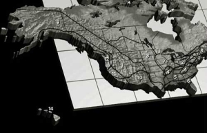
この手法をとった結果我々は米国を14の地域に分割し(地図1:35K)、それぞれの地域について1章を割いて論じている。その14地域とは、メガロポリス(巨大都市)、米国製造業中枢、取り残された東部、アパラチア山地(Appalachian Highlands)とオザーク台地(Ozark Plateau)、ディープサウス(深南部)、南部沿岸地帯、農業中枢、グレートプレーンズ(Great Plains)とプレーリー(Prairie)、無人の内陸部、南西部国境地帯、カリフォルニア、北部太平洋沿岸、北部地方、ハワイである。
本書では事実には反するものの、各地域は概して明確な境界線を持つものとして示されている。私たちは各地域の「風土」を紹介したいと思っている。それは、その場所の持つ機能である。同時にそれは選ばれたテーマが意味する機能でもある。したがって例えば「メガロポリス」の極めて都会的な特徴は第4章で論じるが、「メガロポリス」を構成するニューヨーク、フィラデルフィア、ボストン、その他の製造業の中核都市に関する製造業の側面については第5章で述べる。通常「中西部」と呼ばれる地域の風土には、2つの重要な側面がある。それは都市化と工業化の側面と、田園と農業の2つの側面である。いずれも個別に詳しく論じるにふさわしい重要なものである。
地域の境界線を固定することは米国の景観になじまない。この国のどこかには複数の地域の一部として線引きされた場所があるかもしれないが、多くの地域の境界線は地域の特徴の多くを備えたかなり広い移行地帯となっている。このような移行地帯では様々な特徴が微妙にまたは複雑に交じり合っている場合がある。どこか特定の地域に割り当てるのは難しい。「農業の中枢」と「グレートプレーンズ」の境界域の一部がその一例である。また「農業の中枢」と「ディープサウス(深南部)」の移行地帯の一部も同様である。
地域の境界線も地域自体も固定されたものではない。定住パターンは変化し、社会は重要な新しい技術力を発展させ、政治パターンも手直しされる。地域はこれらのパターンを反映して、拡大や縮小を重ね、現れたり消えたりする。アメリカ大陸が発見された1492年に地域分けが行われていたら1776年や1865年、1991年などに行われた場合とまったく違う結果になっていただろう。2100年の地域分割図が2000年のものと似ているとはとても信じられない。
本稿のために我々が創設した各地域を検証することによって、誰もが認識すべき下位区分が見えてくる。ただし地域によっては普通は予想もしないような組み合わせも見られるかもしれない。例えば「取り残された東部」について考えてみよう。ここはニューヨーク州のアディロンダック山脈とニューイングランドと呼ばれる米北東部の組み合わせである。いい加減な観察者の多くはニューイングランド諸州が強い文化的なつながりを持つ独立した地域として長い間認められてきたことから、自信を持ってニューイングランド全土をまとめて一つの地域とする。しかし移民の増加と都市化により、過去数十年間でニューイングランド南部は大きく変貌をとげているのである。
いくつかの地域は政治的境界線と厳密に一致している。「ハワイ」の場合、その理由は明白である。「カリフォルニア」の場合は米国文化を変化させるという意味で主導的な役割を果たしていることと、地元の資源問題について州全体で政治的な「解決策」を提示している点で近隣のほとんどの地域とは一線を画している。「メガロポリス」は伝統的に郡の境界線に沿って範囲が定められている。
すでに述べたように、各地域について論じた章は、それぞれ1つまたは数個の基本テーマをもとに構成されている。これらのテーマのほとんどは、少なくとも間接的には本書全体の基本テーマから引き出したものである。地域によっては、いくつかのテーマについてより強調されより明確な表現が使われている。各テーマはその地域に関する情報の取り扱いについて明確な基準を提供することを目的としている。ただし、多くの章では、米国または北米大陸に共通する地理的要素を容易に見つけることができるだろう。
*上記の日本語文書は参考のための仮翻訳で、正文は英文です。
Themes and Regions
(The following article is taken from the U.S. Department of State publication, An Outline of American Geography.)
Themes and Regions
By Stephen S. Birdsall and John Florin
This book is about the geography of the United States. And although we look at the country's physical geography, our central interest is not landforms, climate, soils, or vegetation but the human imprint on the landscape.
This does not mean that the physical environment is ignored. In fact, in some instances it holds a central role since the physical environment often plays a significant role in the pattern of people's activities. One factor in the importance of New York City is certainly its location on one of the world's finest natural harbors. Southern Florida's long growing season and mild winters enable it to be a leader in the production of oranges, lemons, and sugarcane.
Still, Florida's mild climate does not automatically mean that it will be a supplier of oranges, and New York City's harbor is only one of many important reasons for the city's growth. The physical environment helps define human opportunities, but it does not in itself determine human activities. In general, the more advanced the level of technology, the greater the leeway a population has in dealing with the land.
It is obviously impossible to cover all the material that might fit into a geography of the United States. We have therefore chosen to divide the country into a number of areas, each of which has a special identity developed out of several interacting elements. We use these elements to form the themes around which each regional chapter is organized.
BASIC THEMES
A few general cultural patterns cut across regional and political boundaries and, in many cases, ignore major differences in the physical environment. These themes characterize the ways Americans have organized their country.
Urbanization: Millions of Americans, most of them urbanites, prefer to consider their country as a basically rural place, and they seem to believe that this rurality provides the country with a basic national vigor.
There is no longer much justification for this view of rural dominance. About 70 percent of Americans live in urban areas, and more than 40 percent are in areas of 1 million people or more. In 1990, the U.S. farm population numbered about 5 million (2 percent of the population), a figure that has declined steadily since the first national census in 1790, when over 90 percent of all Americans were farmers.
Several elements of urbanization are emphasized in our discussion. Cities have a particular form, a particular layout. Most American cities have a rectangular-grid pattern, partly a result of cultural attitudes, partly a result of a desire for efficient transport before the automobile, and partly because that pattern is an easy way to survey the land. Within cities, there is a collection of industrial and commercial centers, residential areas, warehouses, and so on.
Cities exist for many different reasons. They may have an important transportation role. Or they may provide an important administrative function. Perhaps they are a center of recreation or manufacturing. Most cities, certainly all large ones, contain many different urban functions. Nevertheless, many are characterized by certain dominant functions that were the reason for their development and much of their early growth, and that today continue to give them their special character.
The pattern of continuing and often rapid urban growth in the United States during the last 100 years, coupled with the increasing mobility of the urban population, has stimulated a great sprawling pattern of urbanization. In some areas, the result of urban spread is urban coalescence, with the edges of different urban areas meeting and blending.
Industrialization: A substantial part of U.S. employment is related to manufacturing, either directly or indirectly. Most cities were founded and experienced their major periods of growth when manufacturing was the primary factor in urban growth.
Today, there is substantial regional specialization in manufacturing, partly as the result of variations in the availability of industrial raw materials and partly as the result of industrial linkages; manufacturing concerns that produce component parts of some final product are located near each other as well as near the final assembly site to minimize total movement costs.
Other important sources of variation include differences in labor availability or labor skills, in the quality of transportation facilities, and in local political attitudes. Regions tend to specialize in the production of whatever it is that they can best produce. And with this regional specialization has come regional interdependence; few sections of America are truly self-sufficient in manufacturing, in spite of what local pride might lead us to believe.
High Mobility: America's extensive transportation network is an important element in its high level of economic interaction. Goods and people move freely within and between regions of the country. Regional interdependence is great; it is made possible by these interregional flows. Relative isolation is uncommon, but it does exist.
Nearly 20 percent of all Americans change their residence in any one year. Although much of this residential migration is local in nature, it does result in substantial interregional population movement.
Until the last decade of the 19th century, there was a strong westward population shift toward frontier agricultural lands. The focus of opportunity then changed and migration shifted to urban areas. More recently, the U.S. economy has entered what some call a post-industrial phase; employment growth is primarily in professions and services rather than primary (extractive) or secondary (manufacturing) sectors. Such employment is much more flexible in its location, and there has been a more rapid growth in such employment in areas that appear to contain greater amenities.
Resources: About 25 percent of the land in row crops in the United States produces exports. Also, the country is able to satisfy much of its gigantic demand for industrial raw materials domestically. The United States has the potential to be a major supplier for a few nonagricultural raw materials internationally and is the world's leading exporter of coal.
Although the U.S. population is predominantly urban, the extraction of natural resources from its abundant base requires a large nonurban labor force. Furthermore, particularly for agriculture, the development of these resources often involves a substantial land area. As a result, the relationship between the physical environment and human adaptations to that environment are clearly visible. Government plays an important role in this relationship by establishing controls on land use and agricultural production and by regulating the development of many resources. It is partly because processes inherent in urbanization and industrialization lead to high demand for raw materials that the United States has become dependent on imported raw materials in spite of great natural resource abundance.
High Income and High Consumption: The high U.S. national income is achieved through high worker productivity, which requires a significant use of machines. And modern machines are fueled by inanimate energy sources. Mobility also implies heavy use of energy resources. High income spread somewhat evenly among a large share of the population will generate high product demand. All this increases energy consumption.
Americans consume about 25 percent of the world's total energy production. The United States imports half the petroleum it consumes, an increasing share of the iron ore and natural gas used, nearly all of its tin and aluminum, and large quantities of many other mineral ores.
High income also affects diet. Americans eat far more meat products and have a substantially more varied diet than most of the world's population. Beef and dairy production are, therefore, especially important in the agricultural economy.
Environmental Impact: One consequence of high consumption combined with resource abundance and dependence is a strong disruption of the physical environment. Resources seldom can be removed from the natural landscape without some impact, and the manufacture and use of these resources often harm the air and water. The increased severity of such environmental impacts has enlivened the argument between development and conservation – an argument that has stimulated greater governmental intervention in both processes in an attempt to establish a middle ground. As domestic resources become increasingly scarce and their costs of extraction and production increase, the importance of this conflict will grow.
Political Complexity: The United States has a complex political structure, with jurisdiction over an activity or state divided among many different decision-making bodies, some elected and some appointed.
Below the state level, the complexity of the political structure can present a major problem in the effective and efficient distribution of governmental services. Counties, townships, cities, and towns are all governed by their own elected officials. Many special administrative units oversee the provision of specific services, such as education, public transportation, and water supply. The resulting administrative pattern is often nearly impossible to comprehend, because many overlapping jurisdictions may provide one service or another in a given area.
Cultural Origins: The United States has grown from a diverse cultural background. African Americans have made important contributions to the national culture. A distinctive cultural region has developed in the Southwest, with an admixture of Hispanic Americans, American Indians, and European Americans. The Chinese contributed to the life of such cities as San Francisco and New York. This cultural diversity is an important element in the distinctive character of the country.
REGIONS
Geographers use regions as a neat system of categorization, a way of organizing a complex set of facts about places into a more compact, meaningful set of information. As with any categorization, the regions are satisfactory if they identify understandable patterns in the facts and if they help clarify the complex patterns.
To geographers, a region can be either nodal or uniform, single featured or multifeatured. A nodal region is characterized by a set of places connected to another place by lines of communication or movement. The places in the set are associated with each other because they share a common focus, even though each place may be quite different from the others.
In comparison, a uniform region is a territory with one or more features present throughout and absent or unimportant elsewhere. A uniform region may represent some characterization of the total environment of an area, including both its physical and cultural features. It is this type of region that we use for the general structure of this book.
Our perception of the nature of a region, of the things that together shape its personality, is based on a relatively small group of criteria. In each major section of the United States, we have tried to identify the one or two underlying themes that reflect ways in which the population has interacted (within itself or with the physical environment) to create a distinctive region. The most important identifying themes for a region may vary greatly from one region to another. It is impossible to speak of the American Southwest without a focus on aridity and water erosion, of the North without its cold winters, or of the Northeast without cities and manufacturing. The key element that establishes a total uniform region, then, is not how that section compares with others on a predetermined set of variables, but how a certain set of conditions blend there.
This scheme has resulted in our division of the United States into 14 regions (Map 1: 35K), each of which is discussed in its own chapter. These are: Megalopolis, the American Manufacturing Core, the Bypassed East, Appalachia and the Ozarks, the Deep South, the Southern Coastlands, the Agricultural Core, the Great Plains and Prairies, the Empty Interior, the Southwest Border Area, California, the North Pacific Coast, the Northlands, and Hawaii.
Within this book, regions have been presented largely as though they are distinct territorially, even though they are not. The "feeling" of a region we wish to present is a function of place, but it is also a function of the subject theme chosen. Therefore, for example, the intense urban character of Megalopolis is discussed in chapter 4, but the aspects of manufacturing that affect New York, Philadelphia, Boston, and other manufacturing core cites that comprise Megalopolis are presented in chapter 5. There are two important aspects of regional feeling in the region usually called “the Midwest” – the urban-industrial and the rural-agricultural. Both are important enough for us to treat each separately in some detail.
Rigid regional boundaries do not fit the landscape of the United States. A given portion of the country may be occupied by parts of two or more regions, but the boundaries of many regions may also be fairly broad transitional zones that contain many of a region's characteristics. At times, these zones mark an area where the mix of characteristics is so subtle or complex that it is difficult to assign the area to any one region. Parts of the margin between the Agricultural Core and the Great Plains are examples of this, as are sections of the transition between the Agricultural Core and the Deep South.
Regional boundaries and regions themselves are not static. Settlement patterns shift, society develops significant new technological abilities, and political patterns are altered; regions reflecting these patterns may expand, contract, appear, or disappear. A regionalization of the United States for the year of its discovery, 1492, would have been quite different from one for 1776, 1865, or 1991. There is no reason to believe that the pattern for 2100 will be similar to that for 2000.
An examination of the regions that we have created for this text indicates a subdivision that should be generally recognizable, although some regions may represent combinations that are normally not expected. For example, consider the Bypassed East, a combination of the Adirondacks of New York and the northeastern portion of the United States known as New England. Most casual observers firmly lump all of New England into one region, reflecting the long-term identification of the states of New England as a separate region with strong cultural cohesion. But there have been great changes in southern New England in recent decades because of heavy immigration and urbanization.
Several of the regions closely follow political boundaries. The reason for this in Hawaii is obvious. California is separated from most of its adjacent landscape because of its leadership role in changing the culture of America and its statewide political "solutions" to its local resource problems. Megalopolis has been defined traditionally along county lines.
As we mentioned, each of the regional chapters is developed around one or a few basic themes. Most of these themes are drawn at least indirectly from the basic themes of the entire book. In certain regions, the expression of some themes is stronger or clearer than others. The themes are intended to provide an explicit basis for treatment of information about the region, although, in many chapters, it will not be difficult to identify elements of national or continental geography.
[Stephen S. Birdsall is dean of the College of Arts and Sciences at the University of North Carolina at Chapel Hill. He holds a master's and a doctoral degree in geography from Michigan State University and is the co-author of four books and atlases, including Regional Landscapes of the United States and Canada.]
[John Florin is chair of the geography department at the University of North Carolina at Chapel Hill. He holds a master's and a doctoral degree in geography from Pennsylvania State University. His recent publications include Atlas of American Agriculture: The American Cornucopia with Richard Pillsbury and Regional Landscapes of the United States and Canada with Stephen S. Birdsall.]